Amudaryo District
Amudaryo District
| |
|---|---|
 | |
| Country | |
| Autonomous Republic | Karakalpakstan |
| Capital | Mangʻit |
| Area | |
| • Total | 1,020 km2 (390 sq mi) |
| Population (2019) | |
| • Total | 196,900 |
| • Density | 190/km2 (500/sq mi) |
| Time zone | UTC+5 (UZT) |
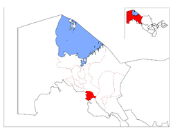
The Amudaryo District (Karakalpak: Ámiwdárya rayonı; Uzbek: Amudaryo tumani) is a district of Karakalpakstan in Uzbekistan. The capital lies at Mangʻit.[1] Its area is 1,020 km2 (390 sq mi) and it had 196,900 inhabitants in 2019.[2]
There are one city (Mangʻit), four towns (Jumurtov, Kipshak, Kilichboy and Xitoy) and 16 village councils (Nazarxon, Oʻrta-qala, Kipshak, Quyuq-qkupir, Xitoy, Oq oltin, Chaykul, Kilichboy, Kangli, Amir Temur, Durman, Bobur nomli, Buzyop, Toʻlqin, Tashyop and Xolimbeg).[1]
References[]
- ^ a b "Classification system of territorial units of the Republic of Uzbekistan" (in Uzbek and Russian). The State Committee of the Republic of Uzbekistan on statistics. July 2020.
- ^ "Districts" (in Russian). Supreme Council of Karakalpakstan. Retrieved 4 February 2022.
This Uzbekistan location article is a stub. You can help Wikipedia by . |
Capital: Nukus | ||
| Districts |  | |
| Cities | ||
| Towns | ||

Categories:
- Uzbekistan geography stubs
- Karakalpakstan
- Districts of Uzbekistan