Karakalpakstan
Coordinates: 43°10′N 58°45′E / 43.167°N 58.750°E

Republic of Karakalpakstan Qoraqalpogʻiston Respublikasi / Қорақалпоғистон Республикаси Qaraqalpaqstan Respublikası Қарақалпақстан Республикасы | |
|---|---|
 Flag
 Emblem
| |
| Motto: Jayhun jagasinda o'sken bayterek | |
| Anthem: "Qaraqalpaqstan Respublikasınıń Mámleketlik Gimni" (English: "State Anthem of the Republic of Karakalpakstan")  | |
 Karakalpakstan in Uzbekistan | |
| Capital | Nukus[1] |
| Official languages | Karakalpak, Uzbek |
| Ethnic groups | Karakalpaks, Uzbeks, Kazakhs |
| Autonomous republic of | |
| Leaders | |
• President | Kamalov Murat |
| Legislature | Supreme Council of Karakalpakstan |
| Establishment | |
• Dissolution of the Karakalpak ASSR | 9 January 1992 |
• New constitution adopted | 9 April 1993 |
| Area | |
• Total | 166,600 km2 (64,300 sq mi) |
| Population | |
• 2017 estimate | 1,817,500 |
• Density | 11.26/km2 (29.2/sq mi) |
| Time zone | UTC+5 (Uzbekistan Standard Time) |
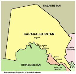
Karakalpakstan (Karakalpak: Qaraqalpaqstan / Қарақалпақстан; Uzbek: Qoraqalpogʻiston), officially the Republic of Karakalpakstan (Karakalpak: Qaraqalpaqstan Respublikası / Қарақалпақстан Республикасы; Uzbek: Qoraqalpogʻiston Respublikasi), is an autonomous republic within Uzbekistan. It occupies the whole northwestern end of Uzbekistan. The capital is Nukus (Noʻkis / Нөкис). The Republic of Karakalpakstan has an area of 160,000 square kilometres (62,000 sq mi). Its territory covers the classical land of Khwarezm, which in classical Persian literature was known as Kāt (کات).
History[]
From about 500 BC to 500 AD, the region of what is now Karakalpakstan was a thriving agricultural area supported by extensive irrigation.[2] It was strategically important territory and fiercely contested, as is seen by the more than 50 Khorezm Fortresses which were constructed here. The Karakalpak people, who used to be nomadic herders and fishers, were first recorded by foreigners in the 16th century.[3] Karakalpakstan was ceded to the Russian Empire by the Khanate of Khiva in 1873.[4] Under Soviet rule, it was an autonomous area within the Russian Soviet Federative Socialist Republic before becoming part of Uzbekistan in 1936.[5] The region was probably at its most prosperous in the 1960s and 1970s, when irrigation from the Amu Darya was being expanded.[citation needed] Today, however, the drainage of the Aral Sea has rendered Karakalpakstan one of Uzbekistan's poorest regions.[3] The region is suffering from extensive drought, partly due to weather patterns, but also largely because the Amu and Syr Darya rivers are exploited mostly in the eastern part of the country. Crop failures have deprived about 48,000 people of their main source of income and shortages of potable water have created a surge of infectious diseases.[6]
Geography[]
Karakalpakstan is now mostly desert and is located in western Uzbekistan near the Aral Sea, in the lowest part of the Amu Darya basin.[1][6][7] It has an area of 164,900 km2[8] and is surrounded by desert. The Kyzyl Kum Desert is located to the east and the Karakum Desert is located to the south. A rocky plateau extends west to the Caspian Sea.[2]
Politics[]
The Republic of Karakalpakstan is formally sovereign and shares veto power over decisions concerning it with Uzbekistan. According to the constitution, relations between Karakalpakstan and Uzbekistan are "regulated by treaties and agreements" and any disputes are "settled by way of reconciliation". Its right to secede is limited by the veto power of Uzbekistan's legislature over any decision to secede.[8] Article 74, chapter XVII, Constitution of Uzbekistan, provides that: "The Republic of Karakalpakstan shall have the right to secede from the Republic of Uzbekistan on the basis of a nationwide referendum held by the people of Karakalpakstan."
Demographics[]

The population of Karakalpakstan is estimated to be around 1.7 million[9] and in 2007 it was estimated that about 400,000 of the population are of the Karakalpak ethnic group, 400,000 are Uzbeks and 300,000 are Kazakhs.[3] The Karakalpak language is considered closer to Kazakh than to Uzbek.[10] The language was written in a modified Cyrillic in Soviet times and has been written in the Latin alphabet since 1996.
The population grew to 1.8 million in 2017. The crude birth rate is 2.19%: approximately 39,400 children were born in 2017. Nearly 8,400 people died in the same period. The crude death rate is 0.47%. The natural growth rate is 31,000, or 1.72%.
The median age was 27.7 years old in 2017, which is younger than the rest of Uzbekistan (median age of 28.5 countrywide). Men are 27.1 years old, while women are 28.2 years old.
Other than the capital Nukus, large cities include Xojeli (Cyrillic: Ходжейли), Taxiatosh (Тахиаташ), Shimbai (Шымбай), Konirat (Қоңырат) and Moynaq (Муйнак), a former Aral Sea port now completely dried up according to NASA.
Economy[]

The economy of the region used to be heavily dependent on fisheries in the Aral Sea. It is now supported by cotton, rice and melons. Hydroelectric power from a large Soviet-built station on the Amu Darya is also important.
The Amu Darya delta was once heavily populated and supported extensive irrigation based agriculture for thousands of years. Under the Khorezm, the area attained considerable power and prosperity. However, the gradual climate change over the centuries, accelerated by human induced evaporation of the Aral Sea in the late 20th century has created a desolate scene in the region. The ancient oases of rivers, lakes, reed marshes, forests and farms are drying up and being poisoned by wind-borne salt and by fertilizer and pesticide residues from the dried bed of the Aral Sea. Summer temperatures have risen by 10 °C (18 °F) and winter temperatures have decreased by 10 °C (18 °F). The rate of anemia, respiratory diseases and other health problems has risen dramatically.[11]
Administrative divisions[]

| District name | District capital | |
|---|---|---|
| 1 | Amudaryo District | Mang‘it |
| 2 | Beruniy District | Beruniy |
| 3 | Shimbay District | Chimboy |
| 4 | Ellikqala District | Bo‘ston |
| 5 | Kegeyli District | Kegeyli |
| 6 | Mo‘ynaq District | Mo‘ynaq |
| 7 | Nukus District | Oqmang‘it |
| 8 | Qonliko‘l District | Qanliko‘l |
| 9 | Qo‘n‘irat District | Qo‘n‘irat |
| 10 | Qarao‘zak District | Qarao‘zak |
| 11 | Shumanay District | Shumanay |
| 12 | Taxtako‘pir District | Taxtako‘pir |
| 13 | To‘rtkul District | To‘rtkul |
| 14 | Xojeli District | Xojeli |
| 15 | Bozataw District | Bozataw |
*Kegeyli district was created in 2004 by the merger of former Bozatau district (the northern part of district 5 on the map) and former Kegeyli district (the south-eastern part of district 5). This merger was effected by Resolution 598-II of the Oliy Majlis of the Republic of Uzbekistan (11 February 2004) and Resolution 225 of the Cabinet of Ministers of the Republic of Uzbekistan (11 May 2004), which abolished Bozatau district and created the enlarged Kegeyli district. Prior to that date, there were 15 districts in Karakalpakstan. See Cabinet of Ministers of the Republic of Karakalpakstan and Karakalpakstan on gov.uz.
**By the decision of the XXVII session of the Supreme Council of the Republic of Karakalpakstan(Tap to see the resolution) on September 4, 2019, Bozataw district was established.
Media[]
Radio[]
In 2009, the first radio station of Karakalpakstan was opened. The station is called Nukus FM, which broadcasts on radio frequency 100.4 MHz, only in Nukus.
See also[]
- Karakalpak Autonomous Oblast, a short-lived Soviet entity
- Delta Blues (documentary film)
- Human rights in Uzbekistan
References[]
- ^ Jump up to: a b Batalden, Stephen K.; Batalden, Sandra L. (1997). The newly independent states of Eurasia: handbook of former Soviet republics. Greenwood Publishing Group. p. 187. ISBN 0-89774-940-5. Retrieved 3 March 2012.
- ^ Jump up to: a b Bolton, Roy (2009). Russian Orientalism: Central Asia and the Caucasus. Sphinx Fine Art. p. 54. ISBN 978-1-907200-00-7. Retrieved 3 March 2012.
- ^ Jump up to: a b c Mayhew, Bradley (2007). Central Asia: Kazakhstan, Tajikistan, Uzbekistan, Kyrgyzstan, Turkmenistan. Lonely Planet. p. 258. ISBN 978-1-74104-614-4. Retrieved 3 March 2012.
- ^ Richardson, David; Richardson, Sue (2012). Qaraqalpaqs of the Aral Delta. Prestel Verlag. p. 68. ISBN 978-3-7913-4738-7.CS1 maint: uses authors parameter (link)
- ^ Europa Publications Limited (2002). Eastern Europe, Russia and Central Asia. Taylor & Francis. p. 536. ISBN 1-85743-137-5. Retrieved 3 March 2012.
- ^ Jump up to: a b Thomas, Troy S.; Kiser, Stephen D.; Casebeer, William D. (2005). Warlords rising: confronting violent non-state actors. Lexington Books. pp. 30, 147–148. ISBN 0-7391-1190-6. Retrieved 3 March 2012.
- ^ Merkel, Broder; Schipek, Mandy (2011). The New Uranium Mining Boom: Challenge and Lessons Learned. Springer. p. 128. ISBN 978-3642221217. Retrieved 7 June 2012.
- ^ Jump up to: a b Roeder, Philip G. (2007). Where nation-states come from: institutional change in the age of nationalism. Princeton University Press. pp. 55, 67. ISBN 978-0-691-13467-3. Retrieved 3 March 2012.
- ^ The State Committee of the Republic of Uzbekistan on Statistics Archived 2012-07-15 at archive.today
- ^ Karakalpakstan: Uzbekistan’s latent conflict Archived 4 March 2016 at the Wayback Machine, 6 January 2012
- ^ Pearce, Fred (2007). When the Rivers Run Dry: Water, the Defining Crisis of the Twenty-first Century. Beacon Press. p. 211. ISBN 978-0-8070-8573-8.
External links[]
| Wikimedia Commons has media related to Karakalpakstan. |
- (in English) Official website of the Council of Ministers of the Republic of Karakalpakstan
- Karakalpakstan Tourism Site
- (in Russian) Photos of Nukus city
- Tours to Karakalpkstan
- http://karakalpak.homestead.com
- Karakalpak music
| show Places adjacent to Karakalpakstan |
|---|

| show Authority control |
|---|
- Karakalpakstan
- Regions of Uzbekistan
- Autonomous republics
- Russian-speaking countries and territories