Anageia
Anageia
Ανάγεια Anagyia | |
|---|---|
village | |
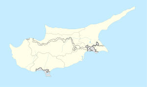 Anageia Location in Cyprus | |
| Coordinates: 35°4′22″N 33°15′7″E / 35.07278°N 33.25194°ECoordinates: 35°4′22″N 33°15′7″E / 35.07278°N 33.25194°E | |
| Country | |
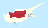
| District | Nicosia District |
| Population (2011)[1] | |
| • Total | 1,514 |
| Time zone | UTC+2 (EET) |
| • Summer (DST) | UTC+3 (EEST) |
| Postcode | 2640 |

Anageia (Greek: Ανάγεια) or Anagyia (Greek: Ανάγυια) is a village in the Nicosia District of Cyprus, which lies approximately 15 km south of the capital Nicosia, just south of the village of Pano Deftera and north of the village of Ergates.
The name of the village comes from the words "Up" and "Agia", meaning "Upper Road". The name is associated with a small road that leads to the village and deviates from the road that connects Nicosia with the mountainous area of Pitsilia.[2]
Anageia has been presented several times by the state with the yearly cleanliness award.[3]
Some notable locations include the old stone church of Saints Nomonos and Vihianos, the old neighbourhoods, which feature narrow streets between traditionally built mud and straw houses, and the community park located at the top of a hill with a panoramic view of the village.[4]
References[]
This Cyprus location article is a stub. You can help Wikipedia by . |
- Communities in Nicosia District
- Cyprus geography stubs