Pano Pyrgos
Pano Pyrgos | |
|---|---|
| Πάνω Πύργος (Greek) | |
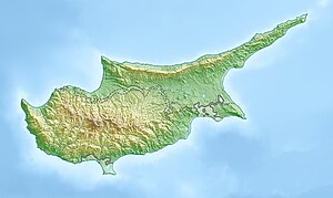 Pano Pyrgos Location in Cyprus | |
| Coordinates: 35°09′15″N 32°40′54″E / 35.15417°N 32.68167°ECoordinates: 35°09′15″N 32°40′54″E / 35.15417°N 32.68167°E | |
| Country | |
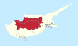
| District | Nicosia District |
| Population (2011)[1] | |
| • Total | 22 |
| Time zone | UTC+2 (EET) |
| • Summer (DST) | UTC+3 (EEST) |

Pano Pyrgos (Greek: Πάνω Πύργος is a village in Cyprus. It is controlled by the Republic of Cyprus. Due to its location, being surrounded by the Troödos Mountains, the Turkish controlled exclave of Kokkina, and the Green Line, it is rather isolated and difficult to reach and gets significant numbers of visitors only in August during summer vacation.
References[]
External links[]
This Cyprus location article is a stub. You can help Wikipedia by . |
Categories:
- Communities in Nicosia District
- Cyprus geography stubs