Angeghakot
Angeghakot
Անգեղակոթ | |
|---|---|
 | |
 Angeghakot | |
| Coordinates: 39°34′05″N 45°56′38″E / 39.56806°N 45.94389°ECoordinates: 39°34′05″N 45°56′38″E / 39.56806°N 45.94389°E | |
| Country | |
| Province | Syunik |
| Municipality | Sisian |
| Area | |
| • Total | 45.79 km2 (17.68 sq mi) |
| Population | |
| • Total | 1,582 |
| • Density | 35/km2 (89/sq mi) |
| Time zone | UTC+4 (AMT) |
| Angeghakot at GEOnet Names Server | |

Angeghakot (Armenian: Անգեղակոթ) is a village in the Sisian Municipality of the Syunik Province in Armenia. A large reservoir, the Angeghakot Reservoir, spanning more than the entire length of the village lies to the south.
Demographics[]
In 1908, Angeghakot, then known as Angelaut (Russian: Ангелаут), had a predominantly Armenian population of 1,520 within the Zangezur Uyezd of the Elisabethpol Governorate of the Russian Empire.[3] The National Statistical Service of the Republic of Armenia (ARMSTAT) reported its population as 2,057 in 2010,[4] up from 1,860 at the 2001 census.[5]
Notable people[]
- Oksen Mirzoyan, Olympic, world and European champion in weightlifting
Gallery[]

Angeghakot Reservoir

Hazaraprkich Church
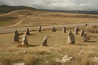
Megalithic rings in Angeghakot

Khachkar

Saint Vardan chapel

Khachkar


References[]
| Wikimedia Commons has media related to Angeghakot. |
- ^ "Syunik regional e-Governance System" (in Armenian). Syunik Province provincial government. Click on link entitled "Համայնքներ" (community) and search for the place by Armenian name.
- ^ Statistical Committee of Armenia. "The results of the 2011 Population Census of the Republic of Armenia" (PDF).
- ^ Кавказский календарь .... на 1910 год (in Russian). Tiflis: Office of the Viceroy of the Caucasus. 1910. p. 182.
- ^ "Marzes of Armenia and Yerevan City in Figures, 2010" (PDF). Statistical Committee of Armenia.
- ^ Report of the results of the 2001 Armenian Census, Statistical Committee of Armenia

This article about a location in Syunik Province, Armenia is a stub. You can help Wikipedia by . |
- Populated places in Syunik Province
- Syunik geography stubs