Khot, Armenia
Khot
Խոտ | |
|---|---|
 | |
 Khot | |
| Coordinates: 39°26′24″N 46°20′10″E / 39.44000°N 46.33611°ECoordinates: 39°26′24″N 46°20′10″E / ��39.44000°N 46.33611°E | |
| Country | |
| Province | Syunik |
| Municipality | Tatev |
| Area | |
| • Total | 17.97 km2 (6.94 sq mi) |
| Population | |
| • Total | 942 |
| • Density | 52/km2 (140/sq mi) |
| Time zone | UTC+4 (AMT) |
| Khot, Armenia at GEOnet Names Server | |

Khot (Armenian: Խոտ) is a village in the Tatev Municipality of the Syunik Province in Armenia. On the cliffs below Khot are the ruins of Hin Khot (Old Khot), the previous location of the village until the 1970s.
Toponymy[]
The village was previously known as Khotavan and Khovt.
Demographics[]
Population[]
The National Statistical Service of the Republic of Armenia (ARMSTAT) reported its population as 1,079 in 2010,[3] up from 890 at the 2001 census.[4] In the 1823 survey of Karabakh, the population was reported to consist of 37 households, all Armenian.[5]
Gallery[]

Mrgadzori khach church

Ruins of Hin Khot
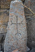
Khatchkar from 1409 in Khot

Hin Khot

17th-18th century khachkar in Khot

Scenery

WWII monument in Khot
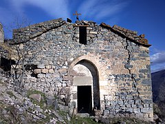
Hin Khot Church


References[]
| Wikimedia Commons has media related to Khot. |
- ^ "Syunik regional e-Governance System" (in Armenian). Syunik Province provincial government. Click on link entitled "Համայնքներ" (community) and search for the place by Armenian name.
- ^ Statistical Committee of Armenia. "The results of the 2011 Population Census of the Republic of Armenia" (PDF).
- ^ "Marzes of Armenia and Yerevan City in Figures, 2010" (PDF). Statistical Committee of Armenia.
- ^ Report of the results of the 2001 Armenian Census, Statistical Committee of Armenia
- ^ В электронную библиотеку: 1866. Описание Карабагской провинции, составленное в 1823 году.

This article about a location in Syunik Province, Armenia is a stub. You can help Wikipedia by . |
- Populated places in Syunik Province
- Syunik geography stubs