Nerkin Khotanan
Nerkin Khotanan
Ներքին Խոտանան | |
|---|---|
 | |
 Nerkin Khotanan | |
| Coordinates: 39°17′01″N 46°22′40″E / 39.28361°N 46.37778°ECoordinates: 39°17′01″N 46°22′40″E / 39.28361°N 46.37778°E | |
| Country | |
| Province | Syunik |
| Municipality | Kapan |
| Area | |
| • Total | 4.36 km2 (1.68 sq mi) |
| Population | |
| • Total | 65 |
| • Density | 15/km2 (39/sq mi) |
| Time zone | UTC+4 (AMT) |
| Nerkin Khotanan at GEOnet Names Server | |
Nerkin Khotanan (Armenian: Ներքին Խոտանան) is a village in the Kapan Municipality of the Syunik Province in Armenia.
Demographics[]
Population[]
The National Statistical Service of the Republic of Armenia (ARMSTAT) reported its population was 70 in 2010,[3] down from 101 at the 2001 census.[4]
Gallery[]
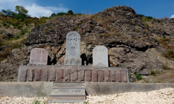
Memorial dedicated to the founders of the village

WWII monument

References[]
- ^ "Syunik regional e-Governance System" (in Armenian). Syunik Province provincial government. Click on link entitled "Համայնքներ" (community) and search for the place by Armenian name.
- ^ Statistical Committee of Armenia. "The results of the 2011 Population Census of the Republic of Armenia" (PDF).
- ^ "Marzes of Armenia and Yerevan City in Figures, 2010" (PDF). Statistical Committee of Armenia.
- ^ Report of the results of the 2001 Armenian Census, Statistical Committee of Armenia

This article about a location in Syunik Province, Armenia is a stub. You can help Wikipedia by . |
Categories:
- Populated places in Syunik Province
- Syunik geography stubs