Aracar
| Aracar | |
|---|---|
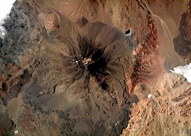 Aracar from the Space Shuttle, January 2003 | |
| Highest point | |
| Elevation | 6,095 m (19,997 ft)[1][a] |
| Prominence | 1,791 m (5,876 ft)[6][7] |
| Parent peak | Ojos del Salado |
| Listing | Ultra |
| Coordinates | 24°17′24″S 67°47′00″W / 24.29000°S 67.78333°WCoordinates: 24°17′24″S 67°47′00″W / 24.29000°S 67.78333°W[6] |
| Geography | |
 Aracar | |
| Parent range | Andes |
| Geology | |
| Age of rock | Pliocene |
| Mountain type | Stratovolcano |
| Last eruption | 1993[8] |
| Climbing | |
| First ascent | 04/01/1958 - Yosko Cvitanic (Yugoslavia), Gustav Lanstchner and Emo Henrich (Austria)[9][10] |

Aracar is a large conical stratovolcano in northwestern Argentina, just east of the Chilean border. It has a main summit crater about 1–1.5 kilometres (0.6–0.9 mi) in diameter which sometimes contains crater lakes, and a secondary crater. The volcano has formed, starting during the Pliocene, on top of a lava platform and an older basement. Constructed on a base with an altitude of 4,100 metres (13,500 ft), it covers a surface area of 192.4 square kilometres (74.3 sq mi) and has a volume of 148 cubic kilometres (36 cu mi). The only observed volcanic activity was a possible steam or ash plume on March 28, 1993, seen from the village of Tolar Grande about 50 km (31 mi) southeast of the volcano, but with no evidence of deformation of the volcano from satellite observations. Inca archeological sites are found on the volcano.
Geology[]
Aracar is located in the Salta province, north of the Salar de Taca Taca and Arizaro and east of the Salar de Incahuasi and the Sierra de Taca Taca,[1][11] close to the Chilean border.[12] Volcanoes in the territory rise above the endorheic sinks and landscape.[1] Cerro Arizaro (9.0 ± 1.3 mya) is another volcano southeast of Aracar.[12]
The basement consists of Paleozoic granites.[11] The north of Aracar was formed by Gondwana volcanism and has been dated by K-Ar methods to be 266 ± 28 Ma old, and it is associated with the Llullaillaco Unit.[13] Tertiary sedimentary rocks in the east and arenites in the south form the rest of the basement. The height of the volcano over the surrounding terrain is between 1,900–2,800 m (6,200–9,200 ft) from north to south.[12]
Aracar is a polygenetic volcanic cone with a diameter of 13.5 km (8.4 mi)[11] and a rectangular basis 12–18 km (7.5–11.2 mi),[12] covering a surface area of 192.4 km2 (74.3 sq mi).[14] Four lava domes extend southeast from the volcano.[12] Grey basaltic lava flows descend from its summit and form a gentle western flank and much steeper eastern, northern and southern flanks.[1] West of the main summit a 1–1.5 km (0.62–0.93 mi) wide and several hundred meters deep crater forms Aracar's main crater. Snowmelt occasionally forms small ephemeral lakes in the main crater. A 100 m (330 ft) shallow 10 m (33 ft) deep secondary crater is surmounted by a flat semilunar 15–20 m (49–66 ft) wide surface.[1][8] Small southbound andesitic lava flows are associated with the main crater.[12] Some deep gorges cut into the volcano,[8] and erosion has removed 1.8 km3 (0.43 cu mi) of rock.[14] Moraines, mainly occurring on the eastern side of the volcano, descend to 4,500 metres (14,800 ft).[15]
A lava field is found beneath Aracar volcano. It is constructed by lava flows that range in composition from basaltic andesite bordering on trachyandesite over dacite and smaller flows of partially silicic magma. Basal lava flows are heavily eroded and reach 14 km (8.7 mi) of length in the south and width decreasing from 4.5 km (2.8 mi) to 1.5 km (0.93 mi). They have cancelled out the prior landscape.[11] These lower lava flows reach the Salar de Taca Taca and extend south-southeast. The main andesitic cone is 900 m (3,000 ft) high and 5 km (3.1 mi) wide and formed on top of older dacitic lava flows. The dacite flows which form the bulk of the edifice are covered with debris and have flow fronts 20–40 m (66–131 ft) high. The lava field formed over a north–south slope.[12]
Lavas have gray-black porphyric and in some places vesicular textures. Andesine-labradorite plagioclase and pyroxene phenocrysts are found in the lavas, which has a fine grained groundmass. Apatite, augite and opaque mineral inclusions are also found. Some lava flows display very small scale flow bands with feldspat and plagioclase inclusions. Xenoliths containing quartz and gabbro nodules also have part in the rock composition. The overall rock composition is calc-alkaline, similar to other magmas in the Central Volcanic Zone with some intraplate and crustal components, with the magmas forming in an open magma chamber.[11] Later magmas may have been influenced by entry of basic magmas from the depth. The total volume of the edifice is about 148 cubic kilometres (36 cu mi).[12]
The volcanic history of Aracar is poorly understood. The bottom lava flows have ages of 3.4 ± 1.2 to 2.6 ± 0.4 mya[11] but an age of 100,000 years has also been given.[15] Presumably at first fluid basaltic lavas were erupted. Subsequently, dacite lavas were erupted, accompanied with the formation of a strong slope in the edifice and hydrothermal activity at a northwestern lava dome. Finally the central crater and andesite lava flows were erupted.[12] Beneath 4,500 m (14,800 ft) altitude lava flows are well conserved. No historical activity is recorded but March 1993, inhabitants of Tolar Grande 50 km (31 mi) southeast of Aracar observed a high ash or steam column rising from Aracar, which may be either an eruption or the result of landslides.[8] Satellite images did not detect any deformation of the edifice during this episode, probably due to aliasing.[16] Aracar is considered Argentina's 17th most dangerous volcano out of 38.[17]
History and human interaction[]
The mountain was first climbed in 1958 by European climbers including Mathias Rebitsch, who found an archeological site in the summit area. Mine fields are present on the northeastern flanks of Aracar, making exploration from that side impossible.[1] A major Inca archeological site is found on Aracar. Two separate places exist on the summit and the secondary crater. The summit place is formed by a stone circle and low stone walls which are placed just above the slopes down into the main crater. A terrace shaped stone structure forms the secondary crater place, being placed on its slopes. A smaller terrace is located on its northeastern side. Timber and wood are found around the stone structures. All these sites have dimensions of no more than 5 m (16 ft). These structures may be a sanctuary site that could be accessed by a bystanding public during ceremonies, with the sites themselves located within wind protected areas.[1]
Notes[]
- ^ Other elevation data are 6,075 metres (19,931 ft) from SRTM,[2] 6,053 metres (19,859 ft) from ASTER[3] and 6,121 metres (20,082 ft) from TanDEM-X.[4] The nearest key col reaches 4,303 metres (14,117 ft) elevation, thus Aracar has a topographic prominence of 1,792 metres (5,879 ft) with a dominance of 29.4%. Its parent peak is Ojos del Salado and the Topographic isolation is 322.5 kilometres (200.4 mi).[5]
See also[]
References[]
- ^ a b c d e f g Ceruti, María Constanza. "Aracar, Guanaquero, Rincón, Arizaro y Blanco: Prospección y relevamiento de santuarios de altura en volcanes de la Puna occidental salteña (República Argentina)". saantropologia.com.ar (in Spanish). Sociedad Argentina de Antropología. Retrieved 12 March 2016.
- ^ USGS, EROS Archive. "USGS EROS Archive - Digital Elevation - SRTM Coverage Maps". Retrieved 12 April 2020.
- ^ "ASTER GDEM Project". ssl.jspacesystems.or.jp. Retrieved 2020-04-14.
- ^ TanDEM-X, TerraSAR-X. "Copernicus Space Component Data Access". Retrieved 12 April 2020.
- ^ "Aracar". Andes Specialists. Retrieved 2020-04-12.
- ^ a b "Argentina and Chile North: Ultra-Prominences" Peaklist.org. Retrieved 2013-02-25.
- ^ "Aracar". Andes Specialists. Retrieved 2020-04-12.
- ^ a b c d "Aracar". Global Volcanism Program. Smithsonian Institution. 12 March 2016.
- ^ Milenco Jurcich. Arqueologia de las Cumbres. pp. 23–24.
- ^ "AAJ (American Alpine Journal)". AAJ (American Alpine Journal): 314. 1959.
- ^ a b c d e f g h i Koukharsky, Magdalena; Etcheverria, Mariela (October 1997). "Geología del volcán Aracar. Sur de los Andes Centrales -24o19'00"S, 67o49'20"0- Argentina" (PDF). biblioserver.sernageomin (in Spanish). Antofagasta: Congreso Geológico Chileno, 8. pp. 1324–1328. Archived from the original (PDF) on 12 March 2016. Retrieved 12 March 2016.
- ^ Poma, Stella; Zappettini, Eduardo O.; Quenardelle, Sonia; Santos, Joao O.; Koukharsky, †Magdalena; Belousova, Elena; McNaughton, Neal J. (30 May 2014). "Geoquímica, dataciones U-Pb SHRIMP sobre circón e isótopos de Hf del magmatismo gondwánico en el NW de Argentina: petrogénesis e implicancias geodinámicas". Andean Geology. 41 (2): 267–292. doi:10.5027/andgeoV41n2-a01.
- ^ a b Karátson, D.; Telbisz, T.; Wörner, G. (February 2012). "Erosion rates and erosion patterns of Neogene to Quaternary stratovolcanoes in the Western Cordillera of the Central Andes: An SRTM DEM based analysis". Geomorphology. 139–140: 122–135. Bibcode:2012Geomo.139..122K. doi:10.1016/j.geomorph.2011.10.010.
- ^ a b Heine, Klaus (2019). Das Quartär in den Tropen (in German). Springer Spektrum, Berlin, Heidelberg. p. 271. doi:10.1007/978-3-662-57384-6. ISBN 978-3-662-57384-6. S2CID 187666121.
- ^ Fournier, T. J.; Pritchard, M. E.; Riddick, S. N. (January 2010). "Duration, magnitude, and frequency of subaerial volcano deformation events: New results from Latin America using InSAR and a global synthesis". Geochemistry, Geophysics, Geosystems. 11 (1): n/a. Bibcode:2010GGG....11.1003F. doi:10.1029/2009GC002558.
- ^ Garcia, Sebastian; Badi, Gabriela (1 November 2021). "Towards the development of the first permanent volcano observatory in Argentina". Volcanica. 4 (S1): 26. doi:10.30909/vol.04.S1.2148. ISSN 2610-3540. S2CID 240436373.
External links[]
- "Cerro Aracar, Argentina" on Peakbagger
- González-Ferrán, Oscar (1995). Volcanes de Chile. Santiago, Chile: Instituto Geográfico Militar. p. 640 pp. ISBN 978-956-202-054-1. (in Spanish; also includes volcanoes of Argentina)
| Wikimedia Commons has media related to Aracar. |
- Stratovolcanoes of Argentina
- Subduction volcanoes
- Active volcanoes
- Mountains of Argentina
- Volcanic crater lakes
- Polygenetic volcanoes
- Six-thousanders of the Andes
- Puna de Atacama