Huambo volcanic field
Coordinates: 15°50′S 72°08′W / 15.83°S 72.13°W[1]

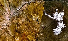
Huambo volcanic field is a volcanic field in Peru. Andahua-Orcopampa lies north-northeast and Sabancaya east of Huambo,[1] east of the Rio Colca.[2] The town of Huambo lies between the two fields.[3]
The northern part of the field was active 700 BCE ± 50 years, forming a large lava flow field and a cinder cone Cerro Keyocc. The southern part of the field contains other cinder cones and lava flows. Some may be of Holocene age.[1] Lava flows are a few 10 metres (33 ft) thick. Four among the volcanoes of the southern field are Marbas Grande, Marbas, Marbas Chico I and Marbas Chico II.[2] The formation of these fields may have been influenced by magma ascent along deep fault systems.[4]
Trachyandesite is the major eruption product of Huambo.[1] The magmas forming this field formed in deep magma chambers with little modification in shallower magma chambers.[2] Basement lava flows have been dated at 1.05±0.04 mya.[3] The Huambo field is located within the Arequipa crustal domain.[4]
References[]
- ^ a b c d "Huambo". Global Volcanism Program. Smithsonian Institution.
- ^ a b c Delacour, Adélie; Gerbe, Marie-Christine; Thouret, Jean-Claude; Wörner, Gerhard; Paquereau-Lebti, Perrine (17 November 2006). "Magma evolution of Quaternary minor volcanic centres in southern Peru, Central Andes" (PDF). Bulletin of Volcanology. 69 (6): 581–608. doi:10.1007/s00445-006-0096-z. hdl:20.500.11850/67949.
- ^ a b Andean Volcanism: Nevado Hualca Hualca Volcano, Southern Peru, and El Reventador Volcano, Ecuador. ProQuest. 2008. pp. 34–35. ISBN 978-0-549-36997-4.
- ^ a b Mamani, M.; Worner, G.; Sempere, T. (25 September 2009). "Geochemical variations in igneous rocks of the Central Andean orocline (13 S to 18 S): Tracing crustal thickening and magma generation through time and space". Geological Society of America Bulletin. 122 (1–2): 162–182. doi:10.1130/B26538.1.
This volcanology article is a stub. You can help Wikipedia by . |
- Volcanoes of Peru
- Volcanic fields
- Holocene volcanism
- Volcanology stubs