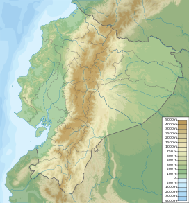
Chimborazo
| Chimborazo | |
|---|---|
 The summit of Chimborazo, the point on the Earth's surface that is farthest from the Earth's center | |
| Highest point | |
| Elevation | 6,263.47 m (20,549.4 ft)[note 1] |
| Prominence | 4,118 m (13,510 ft)[1] Ranked 18th |
| Isolation | 846 km (526 mi) |
| Listing | Country high point Ultra |
| Coordinates | 01°28′09″S 78°49′03″W / 1.46917°S 78.81750°WCoordinates: 01°28′09″S 78°49′03″W / 1.46917°S 78.81750°W |
| Geography | |
 Chimborazo | |
| Country | Ecuador |
| Province | Chimborazo Province |
| Parent range | Andes, Cordillera Occidental |
| Topo map | IGM, CT-ÑIV-C1[2] |
| Geology | |
| Age of rock | Paleogene[3] |
| Mountain type | Stratovolcano |
| Last eruption | 550 AD ± 150 years[4] |
| Climbing | |
| Easiest route | Glacier/snow climb PD |

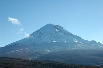
Chimborazo (Spanish pronunciation: [tʃimboˈɾaso] (![]() listen)) is a currently inactive stratovolcano in the Cordillera Occidental range of the Andes. Its last known eruption is believed to have occurred around 550 A.D.[4]
listen)) is a currently inactive stratovolcano in the Cordillera Occidental range of the Andes. Its last known eruption is believed to have occurred around 550 A.D.[4]
Chimborazo's summit is also the farthest point on the Earth's surface from the Earth's center given that it is located along the planet's equatorial bulge. Chimborazo's summit, however, is not higher than the summit of Mount Everest, as elevation is measured from sea level.
With a peak elevation of 6,263 m (20,548 ft), Chimborazo is the highest mountain in Ecuador. It is only the 39th highest peak in the Andes.[5] Like Everest, Chimborazo is also known for climbing; its climb demands skill and is often on black ice, so crampons and other high-tech climbing equipment are required.
Geography[]
Location[]
Chimborazo is in the Chimborazo Province of Ecuador, 150 km (93 mi) south-southwest of the city of Quito, Ecuador. It is a neighbor to 5,018 m (16,463 ft) high Carihuairazo. Chimborazo's summit rises 2,500 m (8,202 ft) above the surrounding highlands (~3,500 to 4,000 m (11,483 to 13,123 ft)) with a ≈20 km (12 mi) wide base.
Under clear conditions, the summit of Chimborazo can be seen from the coastal city Guayaquil, nearly 140 km (87 mi) away. The nearest cities are Riobamba (~30 km to the southeast), Ambato (~30 km to the northeast) and Guaranda (~25 km to the southwest). Chimborazo is surrounded by the Reserva de Produccion Faunistica Chimborazo, which forms a protected ecosystem to preserve the habitat for the Andes native camelids of vicuña, llama and alpaca.
Chimborazo is at the main end of the Ecuadorian Volcanic Arc, north west of the town of Riobamba. Chimborazo is in la Avenida de los Volcanes (the Avenue of Volcanoes) west of the Sanancajas mountain chain. Carihuairazo, Tungurahua, Tulabug, and El Altar are all mountains that neighbor Chimborazo. The closest mountain peak, Carihuairazo, is 5.8 mi (9.3 km) from Chimborazo.[citation needed] There are many microclimates near Chimborazo, varying from desert in the Arenal to the humid mountains in the Abraspungo valley.[6]
Glaciers[]

The top of Chimborazo is completely covered by glaciers, with some north-eastern glacier arms flowing down to 4,600 m. Its glacier is the source of water for the population of the Bolivar and Chimborazo provinces of Ecuador. Chimborazo glacier's ice mass has decreased over the past decades, which is thought by some to be due to the combined influences of global warming, ash covers from recent volcanic activity[note 2] of Tungurahua, and the El Niño phenomenon.[8][9]
As on other glaciated Ecuadorian mountains, Chimborazo's glacial ice is mined by locals (the so-called Hieleros from Spanish Hielo for Ice) to be sold in the markets of Guaranda and Riobamba. In earlier days, the people transported ice for cooling uses down to coastal towns such as Babahoyo or Vinces.[10]
Elevation[]
With an elevation of 6,263 m (20,548 ft),[note 1] Chimborazo is the highest mountain in Ecuador and the Andes north of Peru; it is higher than any more northerly summit in the Americas.
Farthest point from Earth's center[]
The summit of Mount Everest is higher above sea level, but the summit of Chimborazo is widely reported to be the farthest point on the surface from Earth's center,[12][13][note 3] with Huascarán a very close second.
The summit of Chimborazo is the fixed point on Earth that has the utmost distance from the center – because of the oblate spheroid shape of the planet Earth, which is thicker around the Equator than measured around the poles.[note 4] Chimborazo is one degree south of the Equator and the Earth's diameter at the Equator is greater than at the latitude of Everest (8,848 m (29,029 ft) above sea level), nearly 27.6° north, with sea level also elevated. Despite being 2,585 m (8,481 ft) lower in elevation above sea level, it is 6,384.4 km (3,967.1 mi) from the Earth's center, 2,163 m (7,096 ft) farther than the summit of Everest (6,382.3 km (3,965.8 mi) from the Earth's center).[note 5] However, by height above sea level, Chimborazo is not the highest peak of the Andes.

Vicuña, one of two wild South American camelids.

Chimborazo seen from Riobamba.

Chimborazo volcano.
Chimborazo from the west.


Geology[]
Chimborazo is an ice-capped inactive volcano in Ecuador. Chimborazo is a double volcano composed of one volcanic edifice on top of another.[14] Chimborazo shows four summits; Whymper, Veintimilla, Politecnica, and Nicolas Martínez. The Whymper peak is the highest point on the mountain at 6,263 meters. The Veintimilla peak is about 6,234 m (20,453 ft) high. The Politecnica peak is 5,820 m (19,094 ft) high. The last peak, Nicolas Martínez, is 5,570 m (18,274 ft) high and was named after the father of Ecuadorian mountaineering. The volcano is categorized as a stratovolcano.[14] This type of volcano is characterized as having low slopes at the bottom that gradually get steeper the higher up the mountain.[15] Chimborazo has a circumference of 78 miles (126 km) and a diameter of 30 miles (48 km). Chimborazo's upper elevations are covered in glaciers that are decreasing in size due to climate change and falling ash from the nearby volcano, Tungurahua. In addition to the glaciers, the volcano is covered with craters. The volcano is dominantly andesitic to dacitic. This means that the lava is blocky, or flowing down the sides of the volcano, or somewhere in between.[16]
Chimborazo is 73.5 metres higher than the highest mountain in North America. Chimborazo is often associated with the nearby volcano Cotopaxi, although the two volcanoes have completely different structures.
Volcanism[]

Chimborazo is a dominantly andesitic-dacitic stratovolcano. About 35,000 years ago a collapse of Chimborazo produced a debris avalanche with an average thickness of forty meters. which underlies the city of Riobamba. It temporarily dammed the , causing an ephemeral lake.[14]
Chimborazo then erupted several times during the Holocene, the last time around 550 AD ± 150 years.[4] The eruptions after the collapse were primarily andesitic, or blocky, coagulated lava flow. These eruptions produced pyroclastic surges that went down as far as 3800 meters altitude.[14] There have been at least seven eruptions in the past 10000 years. Chimborazo is officially considered inactive, but studies show that there may be an eruption in the future.[citation needed] The average time between eruptions for Chimborazo is 1000 years,[citation needed] and the last eruption was 1400 years ago.

History[]

Until the beginning of the 19th century, it was thought that Chimborazo was the highest mountain on Earth (measured from sea level), and such reputation led to many attempts on its summit during the 17th and 18th centuries.
In 1746, the volcano was explored by French academicians from the French Geodesic Mission. Their mission was to determine the sphericity of the Earth. Their work along with another team in Lapland established that the Earth was an oblate spheroid rather than a true sphere. They did not reach the summit of Chimborazo.
In June 1802, during his expedition to South America, the Prussian-born traveler Alexander von Humboldt, accompanied by the French botanist Aimé Bonpland and the Ecuadorian , tried to reach the summit.[17] From his description of the mountain, it seems that before he and his companions had to return suffering from altitude sickness they reached a point at 5,875 m, higher than previously attained by any European in recorded history (Incans had reached much higher altitudes previously; see Llullaillaco). In 1831, Jean Baptiste Boussingault and Colonel Hall reached a new "highest point", estimated to be 6,006 m.[18][19]
Other failed attempts to reach the summit followed.
On 4 January 1880, the English climber Edward Whymper reached the summit of Chimborazo.[20] The route that Whymper took up the mountain is now known as the Whymper route. Edward Whymper, and his Italian guides Louis Carrel and Jean-Antoine Carrel, were the first Europeans to summit a mountain higher than 20,000 feet (6,100 m).[21] As there were many critics who doubted that Whymper had reached the summit, later in the same year he climbed to the summit again, choosing a different route (Pogyos) with the Ecuadorians David Beltrán and Francisco Campaña.[22]
SAETA Flight 232[]
In August 1976, SAETA Flight 232 carrying 55 passengers and four crew members aboard a Vickers Viscount from Quito to Cuenca disappeared en route. In February 2003, after almost 27 years,[23] the aircraft was found with the bodies of its 59 occupants at 5,310 metres (17,420 ft) elevation on Chimborazo by Ecuadorian climbers on the rarely used eastern route Integral.[24]
Etymology[]
Several theories regarding the origin of the name Chimborazo exist. In many dialects of Quichua or Quechua, "chimba" means "on the other side" as in "on the other side of the river" or "on the opposite bank." Other dialects pronounce this word "chimpa." Also, "razu" means "ice" or "snow." Local Quichua speakers will say that Chimborazo is a Hispanicized pronunciation of "chimbarazu," meaning "the snow on the other side."[25] Another theory suggests it is a combination of the Cayapa Schingbu for Women and the Colorado/Quichua Razo for Ice/Snow resulting in Women of Ice. According to another, Chimbo is Jívaro for Throne of Master/God resulting in Icethrone of God. The locals also used to call the mountain Urcurazu, with the Quichua Urcu for Mountain resulting in Mountain of Ice.[26] In local indigenous mysticism, Chimborazo represents Taita (Father) whereas neighbouring Tungurahua is seen as Mama, and Guagua (Child) for Pichincha hence Taita Chimborazo, Mama Tungurahua and Guagua Pichincha.
Mountaineering[]

As Ecuador's highest mountain, Chimborazo is a very popular climb and can be climbed year round with the best seasons being December–January and July–August.
Routes[]
The easiest (IFAS Grade: PD) and most climbed routes are the Normal and the Whymper route. Both are western ridge routes starting at the Whymper hut and leading via the Ventemilla summit to the main (Whymper) summit. There are several other less used and more challenging routes on the other mountains faces and ridges leading to one of Chimborazo's summits: Main (Whymper, Ecuador), Politecnico (Central), N. Martinez (Eastern). The mountain is contained on the IGM (Instituto Geografico Militar) 1:50000 Map Chimborazo (CT-ÑIV-C1).[2]
Huts[]
There are two functioning huts, the Carrel Hut (4,850 m) and the nearby Whymper Hut (5,000 m). The Carrel Hut can be reached by car from Riobamba, Ambato or Guaranda. On the north-west side there is the now defunct Zurita hut (4,900 m), which served as base for the Pogyos route.[26]
Climbing[]
El Castillo is the most popular route up the volcano. This route is usually climbed December to February and June to September. This route involves climbing the west side of the volcano. The route starts at Whymper hut to a saddle above El Castillo. From the saddle, there is a glacier ridge. Then climbers go to the Veintemilla summit. Veintemilla summit is often the turnaround point for climbers. There is a 30-minute snow-filled basin between Veintemilla summit and Whymper summit. Whymper summit is the highest point of the mountain. The El Castillo route takes around eight to twelve hours to ascend and about three to five hours to descend. Climbing Chimborazo is dangerous due to the risk of avalanches, the severe weather conditions, and the fact that it is covered in glaciers. Climbing begins at night in order to reach the summit before sunrise when the snow melts, which increases the chance of avalanche and rockfall.
The climb itself demands skill. The climb is often on black ice, so crampons and other technical climbing equipment are required. On November 10, 1993 three parties of climbers, one ascending and two descending, were caught in an avalanche on the steep slopes below the Veintimilla summit. This avalanche buried ten climbers in a crevasse at 18,700 feet (5,700 m). These climbers comprised six French, two Ecuadorians, one Swiss, and one Chilean. After the ten climbers were buried in snow, it took twenty people and ten days to find their bodies. This was considered the worst climbing accident in Ecuador.[21]
Cultural references[]
- Chimborazo is featured on the Ecuadorian coat of arms, to represent the beauty and richness of the Ecuadorian Sierra (Highlands).
- Simón Bolívar's poem, "Mi delirio sobre el Chimborazo", was inspired by the mountain.
- In his central essay "The Poet," Ralph Waldo Emerson uses the Chimborazo as metaphor for the poet (and the creative genius in general), who "must stand out of our low limitations."
- Walter J. Turner's poem, "Romance" contains the couplet "Chimborazo, Cotopaxi/They had stolen my soul away!"[27]
- The American landscape painter Frederick Edwin Church features the Chimborazo in the background of his famous work The Heart of the Andes (1859) as well as in his painting Chimborazo (1864).[28]
- wrote a poem entitled "Canto al Chimborazo" (Song to Chimborazo).[29]
See also[]
Notes[]
- ^ Jump up to: a b The elevation given here was established by a GPS survey in February 2016. The survey was carried out by a team from the French Research Institute for Development, working in cooperation with the Ecuadorian Military Geographic Institute.[11]
- ^ Tungurahua's recent activity period started in 1999 with the most significant eruptions between October and December 1999 and May and July 2006.[7]
- ^ A diagram that compares the height of Chimborazo and Mount Everest could be found in "What is the highest point on Earth as measured from Earth's center?". U.S. National Oceanic and Atmospheric Administration. Archived from the original on 2016-05-28.
- ^ It has been difficult to resolve this issue definitively because of error margins in summit elevations and geoid data. Application of the formula at Earth radius#Radius at a given geodetic latitude shows that the Earth's radius is 520 metres (1,710 ft) greater at Chimborazo than at Huascaran, with most recent data showing another 5 metres (16 ft) due to local variations in gravity, for a total of 525 metres (1,722 ft). Two heights are given for Huascarán - 6,746 m (22,133 ft) from the Peruvian National Geographic Institute (IGN) map, and 6,768 m (22,205 ft) from the Austrian Alpine Club (OeAV) survey map. Chimbaro is now 6,263 m (20,548 ft). Thus Chimborazo's summit is roughly either 20 metres (66 ft) or 40 metres (130 ft) further from the Earth's center than that of Huascaran.
- ^ In this ranking, several other Andean peaks as well as Africa's highest mountain, Kilimanjaro, exceed Everest.
References[]
- ^ ""Ecuador" Ultras". Peaklist.org. Retrieved 2012-11-06.
- ^ Jump up to: a b "Chimborazo Ecuador, CT-ÑIV-C1". IGM (Instituto Geografico Militar, Ecuador). 1991. Archived from the original on 2012-04-25. Retrieved 2008-01-26.
- ^ Gomez, Nelson (1994). Atlas del Ecuador. Editorial Ediguias. ISBN 9978-89-009-2.
- ^ Jump up to: a b c "Chimborazo". Global Volcanism Program. Smithsonian Institution. Retrieved 2009-01-01.
- ^ , Wikipedia, 2020-01-15, retrieved 2020-01-20
- ^ hleduc. "Volcano of Ecuador Chimborazo volcano climbing route Chimborazo mountain Ecuador". terranovatrek.com. Archived from the original on 2013-03-07.
- ^ "Actinstituto Geofísico, EPN Ecuador". Archived from the original on 2007-06-13. Retrieved 2007-04-28.
- ^ Chaffaut, Isabelle; Marie Guillaume (2004). "El Niño and glacier melt in the tropical Andes". innovations report. Retrieved 2006-08-08.
- ^ Schoterer, Ulrich; Grosjean M.; Stichler W; et al. (2003). "Glaciers and Climate in the Andes between the Equator and 30° S: What is Recorded under Extreme Environmental Conditions?". Climatic Change. 59: 157–175. doi:10.1023/A:1024423719288. S2CID 129350422.
- ^ Borja, Carmen (2004). "Hieleros del Chimborazo. Entrevista a Igor Guayasamín". Ecuador Terra Incognita. 29.
- ^ "Chimborazo, el volcán de Ecuador más alto que el Everest (si se mide desde el centro de la Tierra)". BBC Mundo. 7 April 2016. Retrieved 2016-04-08.
- ^ Audrey Salkeld, ed., World Mountaineering, Bulfinch Press, 1998, ISBN 0-8212-2502-2, p. 140.
- ^ Krulwich, Robert (April 7, 2007). "The 'Highest' Spot on Earth?". NPR. Archived from the original on 2007-04-09. Retrieved 2014-04-23.
- ^ Jump up to: a b c d Alcaraz et al. (2005) "The debris avalanche of Chimborazo, Ecuador", 6th International Symposium on Andean Geodynamics (ISAG 2005, Barcelona), Extended Abstracts: 29-32
- ^ "How Volcanoes Work - Stratovolcanoes". Department of Geological Sciences. San Diego State University. Retrieved 2014-04-24.
- ^ "How Volcanoes Work - Andesitic to Rhyolitic Lava". Department of Geological Sciences. San Diego State University. Retrieved 2014-04-24.
- ^ Daum, Andreas (2019). Alexander von Humboldt. Munich: C. H. Beck. pp. 56‒58. ISBN 978-3-406-73436-6.
- ^ "Greatest Ascents in the Atmosphere". The Times (16202). London. September 7, 1836. col E, p. 2.
- ^ McCosh, Frederick William James (1984). Boussingault: Chemist and Agriculturist. Dordrecht: D. Reidel. ISBN 90-277-1682-X.
- ^ "Ascent Of Chimborazo". The Cornishman (92). 15 April 1880. p. 3.
- ^ Jump up to: a b "Fast Facts About Chimborazo". About.com. Retrieved 2014-04-23.
- ^ Whymper, Edward (1892). Travels Amongst the Great Andes of the Equator. John Murray. ISBN 1-904466-24-9.
- ^ "Plane crash's frozen victims found 27 years later". The Sidney Morning Herald. February 19, 2003. Retrieved 2014-04-23.
- ^ El Comercio (February–May 2003). "Different Saeta Chimborazo accident articles" (in Spanish). El Comercio, Quito.
- ^ one online Quechua dictionary which verifies this etymology is as http://www.philip-jacobs.de/runasimi/runasimi.txt Archived 2011-11-08 at the Wayback Machine
- ^ Jump up to: a b Schmudlach, Günter (2001). Bergführer Ecuador. Panico Alpinverlag. ISBN 3-926807-82-2.
- ^ Marsh, Edward Howard, Sir (1917). Georgian Poetry, 1916–1917. The Poetry Bookshop. Retrieved 2008-06-23.
- ^ "Chimborazo". The Huntington. Retrieved 2020-06-08.
- ^ Biblioteca Virtual Miguel de Cervantes - Sección Poetas Parnasianos y Modernistas "Canto al Chimborazo (Miguel Ángel León)"
External links[]
| Wikimedia Commons has media related to Chimborazo. |
- "Volcán Chimborazo, Ecuador". Peakbagger.com. Retrieved 2012-11-06.
- "Climbing information for Chimborazo". Summitpost.org. Retrieved 2011-10-25.
- "The last iceman of Chimborazo". Retrieved 2011-10-25.
| show Authority control |
|---|
- Mountains of Ecuador
- Stratovolcanoes of Ecuador
- Geography of Chimborazo Province
- Andean Volcanic Belt
- Extreme points of Earth
- Glaciers of Ecuador
- Quaternary volcanoes
- Quaternary South America
- Tourist attractions in Chimborazo Province
- Highest points of countries
- Six-thousanders of the Andes
- Climbing areas of Ecuador