Artavan
Coordinates: 39°39′27″N 45°37′00″E / 39.65750°N 45.61667°E

Artavan
Արտավան | |
|---|---|
 | |
 Artavan | |
| Coordinates: 39°39′27″N 45°37′00″E / 39.65750°N 45.61667°E | |
| Country | |
| Province | Vayots Dzor |
| Municipality | Zaritap |
| Population | |
| • Total | 321 |
| Time zone | UTC+4 (AMT) |
| Artavan at GEOnet Names Server | |
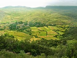
Artavan (Armenian: Արտավան) is a village in the Zaritap Municipality of the Vayots Dzor Province in Armenia. The village was probably at one time a fief of Tatev. There is an 18th-century bridge and an old cemetery in the vicinity of the village.
Toponymy[]
The village was previously known as Dzhul.
Gallery[]


References[]
External links[]
| Wikimedia Commons has media related to Artavan. |
- Report of the results of the 2001 Armenian Census, Statistical Committee of Armenia
- Kiesling, Brady (2005), Rediscovering Armenia: Guide, Yerevan, Armenia: Matit Graphic Design Studio
- Brady Kiesling, Rediscovering Armenia, p. 128; original archived at Archive.org, and current version online on Armeniapedia.org.
Capital: Yeghegnadzor | |||||||||||
| Urban municipalities |
|  | |||||||||
| Rural municipalities |
| ||||||||||
This article about a location in Vayots Dzor Province, Armenia is a stub. You can help Wikipedia by . |
Categories:
- Populated places in Vayots Dzor Province
- Vayots Dzor geography stubs