Shatin, Armenia
Coordinates: 39°50′00″N 45°18′06″E / 39.83333°N 45.30167°E

Shatin
Շատին | |
|---|---|
 | |
 Shatin | |
| Coordinates: 39°50′00″N 45°18′06″E / 39.83333°N 45.30167°E | |
| Country | |
| Province | Vayots Dzor |
| Municipality | Yeghegis |
| Population | |
| • Total | 1,736 |
| Time zone | UTC+4 (AMT) |
| Shatin, Armenia at GEOnet Names Server | |
Shatin (Armenian: Շատին) is a village and the center of the Yeghegis Municipality of the Vayots Dzor Province in Armenia. It is home to the only mountain goat observation point in Armenia. The observation point was constructed with the help of the Norwegian and Armenian governments, the World Wildlife Fund and Safari organizations. Tourists can come to see the mountain goats from these observation points. The village also has several archeological sites from various periods in Armenian history.
Toponymy[]
The village was previously known as Shatik, Hesan Kand, Gasankend and Hasankand.
Gallery[]
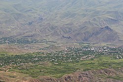
A view of the village
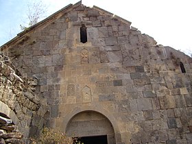
Shativank

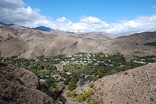
Scenery around Shatin

Shativank interior

A view of the village

Shativank


References[]
External links[]
| Wikimedia Commons has media related to Shatin. |
- World Gazeteer: Armenia[dead link] – World-Gazetteer.com
- Report of the results of the 2001 Armenian Census, Statistical Committee of Armenia
Capital: Yeghegnadzor | |||||||||||
| Urban municipalities |
|  | |||||||||
| Rural municipalities |
| ||||||||||
This article about a location in Vayots Dzor Province, Armenia is a stub. You can help Wikipedia by . |
- Populated places in Vayots Dzor Province
- Vayots Dzor geography stubs