Atherton, California
Atherton, California | |
|---|---|
Town in California | |
| Town of Atherton | |
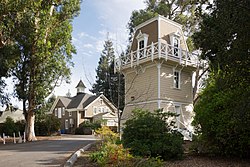 Holbrook-Palmer Park | |
 Seal | |
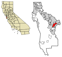 Location of Atherton in San Mateo County, California | |
 Atherton Location in the United States | |
| Coordinates: 37°27′31″N 122°12′0″W / 37.45861°N 122.20000°WCoordinates: 37°27′31″N 122°12′0″W / 37.45861°N 122.20000°W[1] | |
| Country | United States |
| State | California |
| County | San Mateo |
| Incorporated | September 12, 1923[2] |
| Named for | Faxon Dean Atherton[2] |
| Government | |
| • City council[3] |
|
| • Assemblymember | Marc Berman (D) (24th)[4] |
| • State Senator | Josh Becker (D) (13th)[4] |
| • U.S. Rep. | Anna Eshoo (D) (18th)[5] |
| Area | |
| • Total | 5.05 sq mi (13.07 km2) |
| • Land | 5.02 sq mi (12.99 km2) |
| • Water | 0.03 sq mi (0.08 km2) 0.63% |
| Elevation | 59 ft (18 m) |
| Population | |
| • Total | 6,914 |
| • Estimate (2019)[8] | 7,137 |
| • Density | 1,422.85/sq mi (549.35/km2) |
| Time zone | UTC−8 (Pacific) |
| • Summer (DST) | UTC−7 (PDT) |
| ZIP Code[9] | 94027 |
| Area code[10] | 650 |
| FIPS code | 06-03092 |
| GNIS feature IDs | 1657960, 2411651 |
| Website | www |


Atherton is an incorporated town in San Mateo County, California, United States. Its population was 6,914 as of 2010.
Atherton is known for its wealth; in 1990 and 2019,[11] Atherton was ranked as having the highest per capita income among U.S. towns with a population between 2,500 and 9,999,[12] and it is regularly ranked as the most expensive ZIP Code in the United States.[13][14][15]
Geography[]
Atherton is located at 37°27′31″N 122°12′00″W / 37.458615°N 122.200099°W.[16]
According to the United States Census Bureau, the town has a total area of 5.0 square miles (13 km2), of which, 5.0 square miles (13 km2) of it is land and 0.03 square miles (0.078 km2) of it (0.63%) is water.
Atherton lies two miles (3.2 km) southeast of Redwood City, and 18 miles (29 km) northwest of San Jose. The town is considered to be part of the San Francisco metropolitan area.
The town has a former Caltrain station which permanently closed in December 2020.[17]
Government[]
Atherton's current land use goal is "To preserve the Town's character as a scenic, rural, thickly wooded residential area with abundant open space."[18]
In the California State Legislature, Atherton is in the 13th Senate District, represented by Democrat Josh Becker, and in the 24th Assembly District, represented by Democrat Marc Berman.[19]
In the United States House of Representatives, Atherton is in California's 18th congressional district, represented by Democrat Anna Eshoo.[20]
The city is served by the Atherton Public Library of the San Mateo County Libraries, a member of the Peninsula Library System.
Demographics[]
| Historical population | |||
|---|---|---|---|
| Census | Pop. | %± | |
| 1930 | 1,324 | — | |
| 1940 | 1,908 | 44.1% | |
| 1950 | 3,630 | 90.3% | |
| 1960 | 7,717 | 112.6% | |
| 1970 | 8,085 | 4.8% | |
| 1980 | 7,797 | −3.6% | |
| 1990 | 7,163 | −8.1% | |
| 2000 | 7,194 | 0.4% | |
| 2010 | 6,914 | −3.9% | |
| 2019 (est.) | 7,137 | [8] | 3.2% |
| U.S. Decennial Census[21] | |||
In September 2010, Forbes magazine placed Atherton's ZIP code of 94027 at #2 on its annual list of America's most expensive zip codes.[22] In October 2013, 94027 moved to #1 on the list,[23] where it remained through at least 2018,[24][25][26][27] save for 2016 when it appeared at #3.[28] In context, Beverly Hills was placed at #14 in 2015. Atherton had topped the list in earlier decades; a 20-year retrospective showed Atherton also at #1 in 1998.[27] Atherton is one of the wealthiest cities in the United States.[12]
2000[]
At the 2000 census there were 7,194 people in 2,413 households, including 1,984 families, in the town. The population density was 1,467.6 people per square mile (566.9/km2). There were 2,505 housing units at an average density of 511.0 per square mile (197.4/km2).[29] Of the 2,413 households 33.3% had children under the age of 18 living with them, 75.6% were married couples living together, 4.5% had a female householder with no husband present, and 17.8% were non-families. 12.8% of households were one person and 7.5% were one person aged 65 or older. The average household size was 2.85 and the average family size was 3.06.
The age distribution was 23.7% under the age of 18, 7.2% from 18 to 24, 18.7% from 25 to 44, 30.3% from 45 to 64, and 20.2% 65 or older. The median age was 45 years. For every 100 females, there were 93.6 males. For every 100 women age 18 and over, there were 90.2 men.
The median income for a household in the town was in excess of $200,000, as is the median family income. Males had a median income of over $100,000 versus $68,393 for females. The per capita income for the town was $112,408. About 0.8% of families and 1.7% of the population were below the poverty line, including 0.6% of those under age 18 and 3.3% of those age 65 or over.
2010[]
At the 2010 census Atherton had a population of 6,914. The population density was 1,369.5 people per square mile (528.8/km2). The racial makeup of Atherton was 5,565 (80.5%) White, 75 (1.1%) African American, 7 (0.1%) Native American, 911 (13.2%) Asian, 45 (0.7%) Pacific Islander, 95 (1.4%) from other races, and 216 (3.1%) from two or more races. Hispanic or Latino of any race were 268 people (3.9%).[30]
The census reported that 6,529 people (94.4% of the population) lived in households, 385 (5.6%) lived in non-institutionalized group quarters, and no one was institutionalized.
There were 2,330 households, 787 (33.8%) had children under the age of 18 living in them, 1,755 (75.3%) were opposite-sex married couples living together, 109 (4.7%) had a female householder with no husband present, 48 (2.1%) had a male householder with no wife present. There were 34 (1.5%) unmarried opposite-sex partnerships, and 15 (0.6%) same-sex married couples or partnerships. 321 households (13.8%) were one person and 178 (7.6%) had someone living alone who was 65 or older. The average household size was 2.80. There were 1,912 families (82.1% of households); the average family size was 3.03.
The age distribution was 1,543 people (22.3%) under the age of 18, 579 people (8.4%) aged 18 to 24, 966 people (14.0%) aged 25 to 44, 2,264 people (32.7%) aged 45 to 64, and 1,562 people (22.6%) who were 65 or older. The median age was 48.2 years. For every 100 females, there were 96.6 males. For every 100 women age 18 and over, there were 95.3 men.
The median household income was in excess of $250,000, the highest of any place in the United States.[31] The per capita income for the town was $128,816. About 2.9% of families and 5.1% of the population were below the poverty line, including 5.6% of those under age 18 and 5.4% of those age 65 or over.
There were 2,530 housing units at an average density of 501.1 per square mile, of the occupied units 2,116 (90.8%) were owner-occupied and 214 (9.2%) were rented. The homeowner vacancy rate was 1.6%; the rental vacancy rate was 3.9%. 5,921 people (85.6% of the population) lived in owner-occupied housing units and 608 people (8.8%) lived in rental housing units.
Forbes ranked Atherton as second on its list of America's Most Expensive ZIP Codes in 2010, listing median house price as over $2,000,000.[22]
Politics[]
According to the California Secretary of State, as of February 10, 2019, Atherton has 4,953 registered voters. Of those, 1,720 (34.7%) are registered Democrats, 1,541 (31.1%) are registered Republicans and 1,501 (30.3%) have declined to state a political party.[32]
Education[]
Among Atherton's public schools, Encinal, Las Lomitas, and Laurel are elementary schools, while Selby Lane is both an elementary and a middle school. Menlo-Atherton is a high school. Atherton does not have its own public school system. Selby Lane is part of the Redwood City School District, the high school is part of the Sequoia Union High School District, Las Lomitas Elementary School is part of the Las Lomitas Elementary School District, and both Encinal and Laurel are part of the Menlo Park City School District.
Among the town's private schools, Sacred Heart is an elementary, middle and high school, and Menlo School is a middle and high school.
Menlo College is a private four-year college.
Culture and points of interest[]
There are a number of active community organizations: the Atherton Heritage Association, the Atherton Arts Committee, the Atherton Tree Committee, the Friends of the Atherton Community Library, the Holbrook-Palmer Park Foundation, the Atherton Dames, the Police Task Force, and the Atherton Civic Interest League. There are also home owners' associations in various neighborhoods. The Menlo Circus Club is a private club with tennis, swimming, stables and a riding ring located within the town.
There are also several tracts of contemporary Eichler homes, most notably in the Lindenwood neighborhood in the northeast part of the town.[33]
The Holbrook-Palmer Estate, was once an active rural estate and gentleman's farm.[34] The Holbrook-Palmer Estate was donated to the city of Atherton in 1958 and now serves as a 22-acre public park and is listed on the National Register of Historic Places for the architecture.[34]
Notable people[]
- Mohamed Atalla, Egyptian-American engineer, inventor of MOSFET transistor, founder of Atalla Corporation
- Gertrude Atherton, American author
- CiCi Bellis, tennis player
- Lindsey Buckingham, of Fleetwood Mac[35]
- Cheryl Burke, Dancing with the Stars professional dancer
- Sir Nick Clegg, Facebook executive and former Deputy Prime Minister of the United Kingdom, and his wife; Miriam González Durántez, lawyer[36]
- Ty Cobb, Hall of Fame Major League Baseball player
- Stephen Curry, NBA star moved to Atherton when the Golden State Warriors moved to San Francisco in 2019
- Timothy C. Draper, venture capitalist and founder of Draper Fisher Jurvetson[37]
- Clay Dreslough, game designer, raised in Atherton
- Douglas Engelbart, computer engineer
- Drew Fuller, actor, known for role on Charmed and Army Wives
- Ron Johnson, former senior executive at Apple
- Guy Kawasaki, venture capitalist
- Bobbie Kelsey, Stanford University women's basketball assistant coach
- Andy Kessler, author of books on business, technology, and the health field
- Jan Koum, cofounder of WhatsApp
- Charlie Kubal, music producer, created 2010's Mashup Album of the Year, the notorious xx, grew up in Atherton
- Douglas Leone (born 1957), billionaire venture capitalist[38]
- Andy W. Mattes, CEO of Diebold.[39]
- Willie Mays, Hall of Fame Major League Baseball player[40]
- Rajeev Motwani, professor, computer science, Stanford University[41]
- Farzad Nazem, former chief technology officer of Yahoo! and one of its longest-serving executives, now an angel investor
- Chamath Palihapitiya, CEO of Social Capital, and board member of the Golden State Warriors.
- J. B. Pritzker, Governor of Illinois and co-founder of the Pritzker Group
- Tom Proulx, co-founder of Intuit[42]
- Vivek Ranadive, chairman, CEO and Founder of TIBCO Software[43]
- Jerry Rice, Hall of Fame football player[44]
- George R. Roberts, cofounder of Kohlberg Kravis Roberts
- Ted Robinson, San Francisco 49ers play-by-play announcer
- Maureen Kennedy Salaman, author and proponent of alternative medicine
- Sheryl Sandberg, Chief Operating Officer of Facebook
- Eric Schmidt, Executive Chairman and former CEO of Google; 138th-richest person in the world in 2012[45]
- Charles R. Schwab, founder and CEO of the Charles Schwab Corporation[46]
- Shirley Temple, child movie star and diplomat
- Y.A. Tittle, 49ers & Giants QB, NFL HOFer, resident until his death in 2017
- Bob Weir, of the Grateful Dead and Ratdog, raised in Atherton[47]
- Steve Westly, former State Controller of California, major Democratic Party fundraiser, and venture capitalist.[48]
- Meg Whitman, former president and CEO of Hewlett-Packard, former CEO of eBay[49]
- Dennis Woodside, president of Impossible Foods, former COO of Dropbox
See also[]
References[]
- ^ Jump up to: a b "Atherton". Geographic Names Information System. United States Geological Survey. Retrieved August 21, 2009.
- ^ Jump up to: a b "Atherton History". Town of Atherton. April 27, 2007. Archived from the original on September 12, 2009. Retrieved August 21, 2009.
- ^ "City Council". Town of Atherton. Retrieved December 29, 2014.
- ^ Jump up to: a b "Statewide Database". UC Regents. Archived from the original on February 1, 2015. Retrieved December 29, 2014.
- ^ "California's 18th Congressional District - Representatives & District Map". Civic Impulse, LLC. Retrieved March 13, 2013.
- ^ "2019 U.S. Gazetteer Files". United States Census Bureau. Retrieved July 1, 2020.
- ^ "Atherton (city) QuickFacts". United States Census Bureau. Archived from the original on August 16, 2012. Retrieved February 22, 2015.
- ^ Jump up to: a b "Population and Housing Unit Estimates". United States Census Bureau. May 24, 2020. Retrieved May 27, 2020.
- ^ "USPS – ZIP Code Lookup – Search By City". United States Postal Service. Archived from the original on August 30, 2009. Retrieved August 21, 2009.
- ^ "NANP Administration System". North American Numbering Plan Administration. Archived from the original on September 22, 2010. Retrieved August 21, 2009.
- ^ "These Are the Wealthiest Towns in the U.S." Bloomberg. Retrieved August 18, 2018.
- ^ Jump up to: a b Archive of "1990 CPH-L-126. Median Family Income for Places with a Population of 2,500 to 9,999, Ranked Within the United States: 1989", United States Census Bureau. 1990 CPH-L-126F.html Original page
- ^ Levy, Francesca (September 27, 2010). "America's Most Expensive ZIP Codes". Forbes.
- ^ Brennan, Morgan (October 16, 2013). "America's Most Expensive Zip Codes In 2013: The Complete List". Forbes.
- ^ Sharf, Samantha (December 8, 2016). "Full List: America's Most Expensive ZIP Codes 2016". Forbes. Retrieved August 24, 2017.
- ^ "US Gazetteer files: 2010, 2000, and 1990". United States Census Bureau. February 12, 2011. Retrieved April 23, 2011.
- ^ "Proposed Closure of Atherton Caltrain Station". www.caltrain.com. Retrieved December 21, 2020.
- ^ "Town of Atherton General Plan" (PDF). Neal Martin & Associates. November 20, 2002: LU–1. Archived from the original (PDF) on November 4, 2009. Retrieved August 22, 2009. Cite journal requires
|journal=(help) - ^ "Statewide Database". UC Regents. Archived from the original on February 1, 2015. Retrieved November 23, 2014.
- ^ "California's 18th Congressional District - Representatives & District Map". Civic Impulse, LLC.
- ^ "Census of Population and Housing". Census.gov. Retrieved June 4, 2015.
- ^ Jump up to: a b Levy, Francesca (September 27, 2010). "America's Most Expensive ZIP Codes". Forbes.
- ^ Brennan, Morgan (October 16, 2013). "America's Most Expensive Zip Codes In 2013: The Complete List". Forbes.
- ^ "Full List: America's 500 Most Expensive ZIP Codes in 2014".
- ^ "Full List: America's Most Expensive ZIP Codes 2015".
- ^ "Full List: America's Most Expensive ZIP Codes 2017".
- ^ Jump up to: a b "Housing 1998-2018: America's Most Expensive Zip Codes, then and Now".
- ^ "Full List: America's Most Expensive ZIP Codes 2016".
- ^ "U.S. Census website". United States Census Bureau. Retrieved 2008-01-31.
- ^ "2010 Census Interactive Population Search: CA - Atherton town". U.S. Census Bureau. Archived from the original on July 15, 2014. Retrieved July 12, 2014.
- ^ "Highest Income Per Household In The United States By City". Archived from the original on June 27, 2014. Retrieved November 2, 2013.
- ^ "Report of Registration" (PDF). California Secretary of State. February 10, 2019. Retrieved March 11, 2019.
- ^ "Lindenwood Eichler". Retrieved August 24, 2017.
- ^ Jump up to: a b "National Register of Historic Places Registration Form" (PDF). National Park Service, United States Department of the Interior. September 26, 2016. Retrieved October 2, 2020.
- ^ "Lindsay Buckingham with Special Guest Stevie Nicks". Soundstage. HD Ready, LLC and WTTW. 2005. Archived from the original on March 3, 2009. Retrieved January 18, 2009.
- ^ Lumley, Sarah (January 26, 2019). "Nick Clegg swaps Putney townhouse for £7million California mansion ahead of new Facebook role". Telegraph. Retrieved February 9, 2019.
- ^ Palmeri, Christopher; Linda Himelstein (November 6, 2000). "Tim Draper's Voucher Crusade". BusinessWeek. The McGraw-Hill Companies Inc. Archived from the original on September 22, 2010. Retrieved June 25, 2009.
- ^ "Forbes profile: Douglas Leone". Forbes. Retrieved February 1, 2018.
- ^ Cho, Janet H. (June 7, 2013). "New Diebold CEO Andy W. Mattes plans to be direct and ask lots of questions as he steers the company back on track". The Plain Dealer. Cleveland, Ohio. Retrieved October 30, 2016.
He has also worked in China and Brazil, and now lives in Atherton, Calif.
- ^ Taylor, Phil (July 14, 2008). "Willie Mays". Sports Illustrated. Retrieved August 24, 2017.
- ^ AP Associated Press (June 8, 2009). "Stanford computer prof. Rajeev Motwani found dead". SFGate. Hearst Communications Inc. Archived from the original on June 11, 2009. Retrieved June 25, 2009.
- ^ Cortese, Amy (August 7, 1997). "My Jet Is Bigger Than Your Jet". BusinessWeek. The McGraw-Hill Companies Inc. Archived from the original on November 8, 2009. Retrieved June 25, 2009.
- ^ "The Buzz – the week that was". SFGate. Hearst Communications Inc. June 21, 2009. pp. K–1 of the San Francisco Chronicle. Retrieved June 25, 2009.
- ^ The Associated Press (June 6, 2001). "Jerry Rice becomes newest Oakland Raider". The Berkeley Daily Planet. Archived from the original on September 22, 2010. Retrieved June 25, 2009.
- ^ Hansell, Saul (August 8, 2005). "Google's Chief Is Googled, to the Company's Displeasure". The New York Times. Retrieved January 18, 2009.
- ^ "#58 Charles R Schwab". The 400 Richest Americans. Forbes. 2009. Retrieved January 18, 2009.
- ^ McNally, Dennis (2002). A Long Strange Trip: The Inside History of the Grateful Dead. New York: Broadway Books. ISBN 978-0-7679-1185-6.
- ^ "Google staffers quiz candidate Obama". USA Today. USA TODAY, a division of Gannett Co. Inc. November 15, 2007. Retrieved January 18, 2009.
- ^ "The Ripon Profile — Meg Whitman of California, Former CEO of eBay Inc". The Ripon Forum. November–December 2008. Retrieved April 23, 2009.
External links[]
| Wikimedia Commons has media related to Atherton, California. |
| show Municipalities and communities of San Mateo County, California, United States |
|---|

| show San Francisco Bay Area |
|---|

| show Authority control |
|---|
- 1923 establishments in California
- Cities in San Mateo County, California
- Cities in the San Francisco Bay Area
- Incorporated cities and towns in California
- Populated places established in 1923