Azergues
| Azergues | |
|---|---|
 | |
 | |
| Location | |
| Country | France |
| Physical characteristics | |
| Mouth | |
• location | Saône |
• coordinates | 45°56′30″N 4°43′45″E / 45.94167°N 4.72917°ECoordinates: 45°56′30″N 4°43′45″E / 45.94167°N 4.72917°E |
| Length | 62 km (39 mi) |
| Basin size | 886 km2 (342 sq mi) |
| Discharge | |
| • average | 75 m3/s (2,600 cu ft/s) |
| Basin features | |
| Progression | Saône→ Rhône→ Mediterranean Sea |

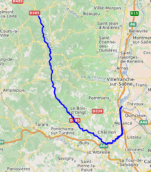
The Azergues (French pronunciation: [azɛʁɡ]) is a river in the Rhône department, in eastern France. It is a right tributary of the Saône, which it joins in Anse. It is 62.4 km (38.8 mi) long.[1] Its source is in the Beaujolais hills, near Chénelette. The Azergues flows through the following towns: Lamure-sur-Azergues,[2] Le Bois-d'Oingt, Chessy, Châtillon, Chazay-d'Azergues and Anse.[1]
Etymology[]
It has been suggested that the name Azergues comes from the Arabic "Azraq" (أزرق), which means blue.[3]
References[]
- ^ Jump up to: a b Sandre. "Fiche cours d'eau - L'Azergues (U46-0400)".
- ^ "Le portail des territoires et des citoyens - Géoportail". Geoportail.fr. Retrieved 2013-02-09.
- ^ http://www.guichetdusavoir.org/viewtopic.php?t=26073
| hide Authority control | |
|---|---|
| General |
|
| National libraries | |
This Rhône geographical article is a stub. You can help Wikipedia by . |
Categories:
- Tributaries of the Saône
- Rivers of France
- Rivers of Rhône (department)
- Rivers of Auvergne-Rhône-Alpes
- Rhône (department) geography stubs
- France river stubs