Bílá (Liberec District)
Bílá | |
|---|---|
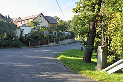 Centre of Bílá | |
 Flag  Coat of arms | |
 Bílá Location in the Czech Republic | |
| Coordinates: 50°39′54″N 15°2′8″E / 50.66500°N 15.03556°ECoordinates: 50°39′54″N 15°2′8″E / 50.66500°N 15.03556°E | |
| Country | |
| Region | Liberec |
| District | Liberec |
| First mentioned | 1537 |
| Area | |
| • Total | 26.30 km2 (10.15 sq mi) |
| Elevation | 383 m (1,257 ft) |
| Population (2021-01-01)[1] | |
| • Total | 973 |
| • Density | 37/km2 (96/sq mi) |
| Time zone | UTC+1 (CET) |
| • Summer (DST) | UTC+2 (CEST) |
| Postal code | 463 43 |
| Website | www |

Bílá is a municipality and village in Liberec District in the Liberec Region of the Czech Republic. It has about 1,000 inhabitants.
Administrative parts[]
Villages of Bohdánkov, Chvalčovice, Dehtáry, Domaslavice, Hradčany, Klamorna, Kocourov, Kohoutovice, Letařovice, Petrašovice, Trávníček, Vesec and Vlčetín are administrative parts of Bílá.
References[]
External links[]
| Wikimedia Commons has media related to Bílá. |
| Authority control: National libraries |
|---|
This Liberec Region location article is a stub. You can help Wikipedia by . |
Categories:
- Populated places in Liberec District
- Villages in Liberec District
- Liberec Region geography stubs