Hrádek nad Nisou
Hrádek nad Nisou | |
|---|---|
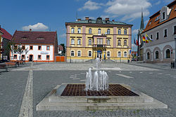 Horní Square | |
 Flag  Coat of arms | |
 Hrádek nad Nisou Location in the Czech Republic | |
| Coordinates: 50°51′10″N 14°50′40″E / 50.85278°N 14.84444°ECoordinates: 50°51′10″N 14°50′40″E / 50.85278°N 14.84444°E | |
| Country | |
| Region | Liberec |
| District | Liberec |
| First mentioned | 1287 |
| Government | |
| • Mayor | Josef Horinka |
| Area | |
| • Total | 48.55 km2 (18.75 sq mi) |
| Elevation | 255 m (837 ft) |
| Population (2021-01-01)[1] | |
| • Total | 7,744 |
| • Density | 160/km2 (410/sq mi) |
| Time zone | UTC+1 (CET) |
| • Summer (DST) | UTC+2 (CEST) |
| Postal code | 463 34 |
| Website | www |

Hrádek nad Nisou (Czech pronunciation: [ˈɦraːdɛk ˈnad ɲɪsou]; German: Grottau, Polish: Gródek nad Nysą) is a town in Liberec District in the Liberec Region of the Czech Republic. It has about 7,700 inhabitants. It lies on the Lusatian Neisse and it is located on the tripoint of Czech Republic, Germany and Poland. The town centre is well preserved and is protected by law as an urban monument zone.
Administrative parts[]

Villages of Dolní Sedlo, Dolní Suchá, Donín, Horní Sedlo, Loučná, Oldřichov na Hranicích, Uhelná and Václavice are administrative parts of Hrádek nad Nisou.
History[]
The first written mention of Hrádek nad Nisou is from 1287. During the Hussite Wars in 1424, the town was burned down. In 1466, the former church was replaced by a Gothic one. In the second half of the 16th century, there was a great development of the estate.[2]
Until 1918, the town was part of the Austrian monarchy (Austria side after the compromise of 1867), in the Reichenberg (Liberec) district, one of the 94 Bezirkshauptmannschaften in Bohemia.[3]
The town had a German majority. The Czech school was founded in 1925. From 1938 to 1945 it was one of the municipalities in Sudetenland. The German population was expelled after the World War II.[2]
Sights[]

Hrádek nad Nisou has a well preserved town centre. The most valuable building is the Church of Saint Bartholomew. Its current appearance is from 1764.[4]
Twin towns – sister cities[]
Hrádek nad Nisou is twinned with:[5]
 Bogatynia, Poland
 Kralupy nad Vltavou, Czech Republic
 Zittau, Germany
References[]
- ^ "Population of Municipalities – 1 January 2021". Czech Statistical Office. 2021-04-30.
- ^ Jump up to: a b "Stručný historický přehled" (in Czech). Město Hrádek nad Nisou. Retrieved 2021-08-15.
- ^ Die postalischen Abstempelungen auf den österreichischen Postwertzeichen-Ausgaben 1867, 1883 und 1890, Wilhelm Klein, 1967
- ^ "Město v srdci Trojzemí" (in Czech). Město Hrádek nad Nisou. Retrieved 2021-08-15.
- ^ "Hrádek nad Nisou a Žitava jsou partnerskými městy" (in Czech). Město Hrádek nad Nisou. 2015-07-01. Retrieved 2019-08-23.
External links[]
| Wikimedia Commons has media related to Hrádek nad Nisou. |
| show Authority control |
|---|
This Liberec Region location article is a stub. You can help Wikipedia by . |
- Populated places in Liberec District
- Cities and towns in the Czech Republic
- Czech Republic–Poland border crossings
- Czech Republic–Germany border crossings
- Liberec Region geography stubs