Baixiang County
Baixiang County
柏乡县 Paisiang | |
|---|---|
 Baixiang in Xingtai | |
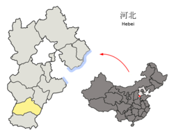 Xingtai in Hebei | |
| Coordinates: 37°28′55″N 114°41′35″E / 37.482°N 114.693°ECoordinates: 37°28′55″N 114°41′35″E / 37.482°N 114.693°E | |
| Country | People's Republic of China |
| Province | Hebei |
| Prefecture-level city | Xingtai |
| Township-level divisions | 3 towns 3 townships |
| County seat | (柏乡镇) |
| Area | |
| • Total | 268 km2 (103 sq mi) |
| Elevation | 39 m (128 ft) |
| Population (2014)[citation needed] | |
| • Total | 193,777 |
| • Density | 720/km2 (1,900/sq mi) |
| Time zone | UTC+8 (China Standard) |
| Postal code | 055450 |
| Area code(s) | 0319 |

Baixiang County (simplified Chinese: 柏乡县; traditional Chinese: 柏鄉縣; pinyin: Bǎixiāng Xiàn) is a county in the southwest of Hebei province, China. It is under the administration of the prefecture-level city of Xingtai, with a population of 193,777 (2014) residing in an area of 268 km2 (103 sq mi). It lies generally to the east of G4 Beijing–Hong Kong–Macau Expressway and China National Highway 107. The Baixiang County is known as being the former capital of the state of Xiang (襄國) of the Southern Huns state Later Zhao, described in the Fang Xuanling Book of Jin Chapter 104, was located in the territory of the county.[1] It was a place of the 351 CE Battle of Xiangguo between Ran Min's army and Shi Zhi of Later Zhao. After the battle, the Later Zhao general (劉顯) killed Shi Zhi in Xiangguo, the Xiangguo city was burned, and its population moved to Yecheng.
Administrative divisions[]
The county administers 3 towns and 3 townships.[2]
Towns[]
- (柏乡镇)
- (固城店镇)
- (西汪镇)
Townships[]
- (王家庄乡)
- (内步乡)
- (龙华乡)
References[]
- ^ Taskin V.S., "Materials on history of nomadic tribes in China 3rd-5th cc", Issue 2 "Jie", "Science", Moscow, 1990, p. 43 on, ISBN 5-02-016543-3
- ^ 2011年统计用区划代码和城乡划分代码:柏乡县 (in Chinese). National Bureau of Statistics of the People's Republic of China. Retrieved 2012-07-21.[permanent dead link]
External links[]
This Xingtai location article is a stub. You can help Wikipedia by . |
- Baixiang County
- County-level divisions of Hebei
- Hebei geography stubs