Xinhe County, Hebei
Xinhe County
新河县 Sinho | |
|---|---|
 Xinhe in Xingtai | |
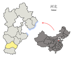 Xingtai in Hebei | |
| Coordinates: 37°31′12″N 115°14′20″E / 37.520°N 115.239°ECoordinates: 37°31′12″N 115°14′20″E / 37.520°N 115.239°E | |
| Country | People's Republic of China |
| Province | Hebei |
| Prefecture-level city | Xingtai |
| County seat | (新河镇) |
| Area | |
| • Total | 366 km2 (141 sq mi) |
| Elevation | 29 m (94 ft) |
| Population | |
| • Total | 170,000 |
| • Density | 460/km2 (1,200/sq mi) |
| Time zone | UTC+8 (China Standard) |
| Postal code | 051730 |

Xinhe (Chinese: 新河; pinyin: Xīnhé; lit. 'new river') is a county in the south of Hebei province, China, located on the (滏阳河), which is part of the Hai River watershed. It is under the administration of the prefecture-level city of Xingtai, with a population of 170,000[when?] residing in an area of 366 km2 (141 sq mi). The county is served by G20 Qingdao–Yinchuan Expressway and China National Highway 308.
Administrative divisions[]
There are 2 towns (镇) and 4 townships (乡):[1]
Towns:
- (新河镇), (寻寨镇)
Townships:
- (白神首乡), (荆家庄乡), (西流乡), (仁让里乡)
References[]
- ^ 2011年统计用区划代码和城乡划分代码:新河县 (in Chinese). National Bureau of Statistics of the People's Republic of China. Retrieved 2012-07-21.
External links[]
| show Authority control |
|---|
This Xingtai location article is a stub. You can help Wikipedia by . |
Categories:
- County-level divisions of Hebei
- Hebei geography stubs