Daming County
Daming County
大名县 Taming | |
|---|---|
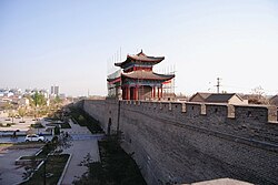
 City walls of Daming | |
 Daming Location in Hebei | |
| Coordinates: 36°17′N 115°09′E / 36.283°N 115.150°ECoordinates: 36°17′N 115°09′E / 36.283°N 115.150°E | |
| Country | People's Republic of China |
| Province | Hebei |
| Prefecture-level city | Handan |
| Area | |
| • Total | 1,052 km2 (406 sq mi) |
| Elevation | 47 m (155 ft) |
| Population | |
| • Total | 749,000 |
| • Density | 710/km2 (1,800/sq mi) |
| Time zone | UTC+8 (China Standard) |
| Postal code | 056900 |
| Website | dm |
| Daming County | |||
|---|---|---|---|
| Traditional Chinese | 大名縣 | ||
| Simplified Chinese | 大名县 | ||
| Literal meaning | Great Name County Famous County | ||
| |||
| Daming Fu | |||
| Chinese | 大名府 | ||
| Literal meaning | Seat of Daming Prefecture | ||
| |||
Daming County is a county under the jurisdiction of Handan City in far southern Hebei Province, China. It was formerly one of the capitals of the Northern Song.
History[]

Song China
It was formerly known as Beijing under the Northern Song dynasty, who used it as their northern capital.[1] The city served as an important centre for learning during Imperial China. It was renamed to Daming Fu during the Ming Dynasty and stayed unchanged until the Republican era.
Administrative divisions[]
Daming County has 6 towns, 13 townships, and 1 ethnic township.[2]
Towns:
- (大名镇), (杨桥镇), (万堤镇), (龙王庙镇), (束馆镇), (金滩镇)
Townships:
- (沙圪塔乡), (王村乡), (铺上乡), (黄金堤乡), (大街乡), (旧治乡), (西未庄乡), (孙甘店乡), (西付集乡), (埝头乡), (北峰乡), (张集乡), (红庙乡), (营镇回族乡)
See also[]
- Other Damings
References[]
- ^ Theobald, Ulrich. China Knowledge. "Chinese History - Song Dynasty 宋 (960-1279): Map and Geography". Accessed 19 Oct 2012.
- ^ 2011年统计用区划代码和城乡划分代码:大名县 (in Chinese). National Bureau of Statistics of the People's Republic of China. Retrieved 2012-07-19.[permanent dead link]
External links[]
Categories:
- County-level divisions of Hebei
- Handan
- Hebei geography stubs
