Luanping County
Luanping County
滦平县 Lwanping | |
|---|---|
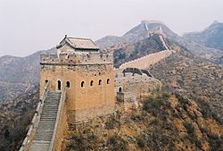 Jinshanling Great Wall | |
 Location in Chengde | |
 Luanping Location of the seat in Hebei | |
| Coordinates (Luanping County government): 40°56′30″N 117°19′57″E / 40.9416°N 117.3326°ECoordinates: 40°56′30″N 117°19′57″E / 40.9416°N 117.3326°E | |
| Country | People's Republic of China |
| Province | Hebei |
| Prefecture-level city | Chengde |
| County seat | (滦平镇) |
| Area | |
| • Total | 3,195 km2 (1,234 sq mi) |
| Elevation | 515 m (1,690 ft) |
| Population | |
| • Total | 293,200 |
| • Density | 92/km2 (240/sq mi) |
| Time zone | UTC+8 (China Standard) |
| Postal code | 068250 |
| Area code(s) | 0314 |
| Website | LPX.gov.cn |

Luanping County (simplified Chinese: 滦平县; traditional Chinese: 灤平縣; pinyin: Luánpíng Xiàn) is a county of northeastern Hebei Province, with the Great Wall of China demarcating its border with Miyun District, Beijing to the southwest. It is under the administration of Chengde City, and as of 2017, has a population of 293,200[1] residing in an area of 3,195 km2 (1,234 sq mi). The G45 Daqing–Guangzhou Expressway, China National Highways 101 and 112, and the Beijing–Tongliao Railway pass through the county. Other bordering county-level divisions are Fengning County to the northwest, Longhua County to the north, Chengde's core districts of Shuangqiao District and Shuangluan District to the east, and Chengde County to the southeast.
Administrative divisions[]

The county administers 1 subdistrict, 10 towns, 2 townships, and 8 ethnic townships.[2]
The county's only subdistrict is .[2]
|
Towns:[2] |
Townships:[2] Ethnic Townships:[2] |
References[]
- ^ "China | Population: Hebei: Chengde: Luanping | Economic Indicators". www.ceicdata.com. Retrieved 2020-01-22.
- ^ a b c d e 2019年统计用区划代码 (in Chinese). National Bureau of Statistics of China. 2019. Archived from the original on 2020-08-19. Retrieved 2020-08-19.
External links[]
This Chengde location article is a stub. You can help Wikipedia by . |
- County-level divisions of Hebei
- Hebei geography stubs