Bakun, Benguet
Bakun | |
|---|---|
| Municipality of Bakun | |
 View of Mount Tenglawan in Bakun | |
 Flag  Seal | |
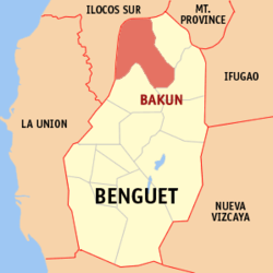 Map of Benguet with Bakun highlighted | |
show OpenStreetMap | |
 Bakun Location within the Philippines | |
| Coordinates: 16°47′32″N 120°39′55″E / 16.7922°N 120.6653°ECoordinates: 16°47′32″N 120°39′55″E / 16.7922°N 120.6653°E | |
| Country | Philippines |
| Region | Cordillera Administrative Region |
| Province | Benguet |
| District | Lone district |
| Barangays | 7 (see Barangays) |
| Government | |
| • Type | Sangguniang Bayan |
| • Mayor | Bill Y. Raymundo |
| • Vice Mayor | Edward P. Buscol |
| • Representative | Nestor B. Fongwan |
| • Electorate | 9,856 voters (2019) |
| Area | |
| • Total | 286.91 km2 (110.78 sq mi) |
| Elevation | 1,466 m (4,810 ft) |
| Highest elevation | 2,133 m (6,998 ft) |
| Lowest elevation | 428 m (1,404 ft) |
| Population (2020 census) [3] | |
| • Total | 14,535 |
| • Density | 51/km2 (130/sq mi) |
| • Households | 3,347 |
| Economy | |
| • Income class | 3rd municipal income class |
| • Poverty incidence | 10.01% (2015)[4] |
| • Revenue | ₱87,545,445.01 (2016) |
| Service provider | |
| • Electricity | Benguet Electric Cooperative (BENECO) |
| Time zone | UTC+8 (PST) |
| ZIP code | 2610 |
| PSGC | |
| IDD : area code | +63 (0)74 |
| Climate type | tropical rainforest climate |
| Native languages | Kankanaey Ibaloi Karao Ilocano Tagalog |
| Website | www |

Bakun, officially the Municipality of Bakun, (Ilocano: Ili ti Bakun; Tagalog: Bayan ng Bakun), is a 3rd class municipality in the province of Benguet, Philippines. According to the 2020 census, it has a population of 14,535 people. [3]
History[]
During the Spanish Period, Bakun was a rancheria of the Commandancia Politico-Militar de Amburayan. Ampusongan (currently a barangay of Bakun) was a rancheria of the Commandancia Politico Militar de Tiagan, Distrito de Benguet.[5]
When the United States took control of the Philippines, the American Congress issued Act No. 48 in November 1900, placing Bakun under the province of Amburayan, and Ampusongan under the province of Benguet.[6] On August 13, 1908, Benguet became a subprovince of the newly established Mountain Province with the enactment of Act No. 1876, and the municipal districts of Bakun and Ampusongan became part of the subprovince.[7]
In 1917, the Bureau of Non-Christian Tribes recommended that the western border of the Mountain Province be pushed eastward, such that the entire subprovince of Amburayan and large slices of Lepanto and Benguet would be made part of Ilocos Sur and La Union. In early 1937, Ampusongan was merged with Bakun, the latter carrying the name of the township while the former became a barangay.[5] The issuance of Republic Act No. 4695 in 1966 included Bakun as a regular municipality in the newly created province of Benguet.[8]
Geography[]
Bakun is located at 16°47′32″N 120°39′55″E / 16.7922°N 120.6653°E, at the northwestern tip of Benguet. It is bounded by Mankayan on the east, Buguias on the southeast, Kibungan on the south, Sugpon on the south-west, Alilem on the north-west, and Cervantes on the north.
According to the Philippine Statistics Authority, the municipality has a land area of 286.91 square kilometres (110.78 sq mi) [9] constituting 10.36% of the 2,769.08-square-kilometre- (1,069.15 sq mi) total area of Benguet.
Bakun is 336 kilometres (209 mi) away from Manila and 86 kilometres (53 mi) away from Baguio.
Barangays[]
Bakun is politically subdivided into 7 barangays.[10]
| PSGC | Barangay | Population | ±% p.a. | |||
|---|---|---|---|---|---|---|
| 2020 [3] | 2010 [11] | |||||
| 141103001 | Ampusongan | 18.1% | 2,625 | 2,178 | 1.82% | |
| 141103002 | Bagu | 5.6% | 820 | 856 | −0.41% | |
| 141103004 | Dalipey | 16.5% | 2,392 | 2,164 | 0.97% | |
| 141103005 | Gambang | 30.0% | 4,367 | 3,705 | 1.60% | |
| 141103007 | Kayapa | 12.0% | 1,741 | 1,527 | 1.27% | |
| 141103009 | Poblacion (Central) | 13.0% | 1,894 | 1,834 | 0.31% | |
| 141103010 | Sinacbat | 10.4% | 1,518 | 1,323 | 1.34% | |
| Total | 14,535 | 13,587 | 0.65% | |||
Climate[]
| hideClimate data for Bakun, Benguet | |||||||||||||
|---|---|---|---|---|---|---|---|---|---|---|---|---|---|
| Month | Jan | Feb | Mar | Apr | May | Jun | Jul | Aug | Sep | Oct | Nov | Dec | Year |
| Average high °C (°F) | 24 (75) |
24 (75) |
25 (77) |
26 (79) |
25 (77) |
24 (75) |
25 (77) |
22 (72) |
23 (73) |
24 (75) |
24 (75) |
23 (73) |
24 (75) |
| Average low °C (°F) | 14 (57) |
15 (59) |
16 (61) |
18 (64) |
19 (66) |
18 (64) |
18 (64) |
18 (64) |
18 (64) |
17 (63) |
16 (61) |
15 (59) |
17 (62) |
| Average precipitation mm (inches) | 42 (1.7) |
48 (1.9) |
74 (2.9) |
110 (4.3) |
269 (10.6) |
275 (10.8) |
362 (14.3) |
325 (12.8) |
330 (13.0) |
306 (12.0) |
126 (5.0) |
61 (2.4) |
2,328 (91.7) |
| Average rainy days | 11.2 | 12.0 | 17.1 | 21.2 | 27.1 | 26.8 | 28.1 | 27.0 | 26.0 | 24.5 | 17.7 | 12.4 | 251.1 |
| Source: Meteoblue [12] | |||||||||||||
Demographics[]
| Year | Pop. | ±% p.a. |
|---|---|---|
| 1903 | 10 | — |
| 1918 | 4,076 | +49.28% |
| 1939 | 4,383 | +0.35% |
| 1948 | 3,390 | −2.81% |
| 1960 | 4,927 | +3.16% |
| 1970 | 6,584 | +2.94% |
| 1975 | 7,932 | +3.81% |
| 1980 | 8,878 | +2.28% |
| 1990 | 10,817 | +2.00% |
| 1995 | 12,836 | +3.26% |
| 2000 | 12,213 | −1.06% |
| 2007 | 12,137 | −0.09% |
| 2010 | 13,587 | +4.19% |
| 2015 | 15,357 | +2.36% |
| 2020 | 14,535 | −1.08% |
| Source: Philippine Statistics Authority [13] [11] [14][15] | ||
In the 2020 census, Bakun had a population of 14,535. [3] The population density was 51 inhabitants per square kilometre (130/sq mi).
Economy[]
| Poverty Incidence of Bakun | |
| Source: Philippine Statistics Authority[16][17][18][19][20][21] | |
Education[]
Public schools[]
As of 2015, Bakun has 30 public elementary schools and 4 public secondary schools.[22][23][24]
References[]
- ^ Municipality of Bakun | (DILG)
- ^ "2015 Census of Population, Report No. 3 – Population, Land Area, and Population Density" (PDF). Philippine Statistics Authority. Quezon City, Philippines. August 2016. ISSN 0117-1453. Archived (PDF) from the original on May 25, 2021. Retrieved July 16, 2021.
- ^ Jump up to: a b c d Census of Population (2020). "Cordillera Administrative Region (CAR)". Total Population by Province, City, Municipality and Barangay. PSA. Retrieved 8 July 2021.
- ^ https://psa.gov.ph/sites/default/files/City%20and%20Municipal-level%20Small%20Area%20Poverty%20Estimates_%202009%2C%202012%20and%202015_0.xlsx; publication date: 10 July 2019; publisher: Philippine Statistics Authority.
- ^ Jump up to: a b "Municipality of Bakun, Benguet". Department of the Interior and Local Government - Cordillera Administrative Region. DILG-CAR. Archived from the original on 22 January 2016. Retrieved 19 January 2021.
- ^ "Benguet: History". Province of Benguet (official website). Archived from the original on 18 September 2014. Retrieved 21 October 2014.
- ^ "Act No. 1876". PhilippineLaw.info. Archived from the original on 15 October 2014. Retrieved 21 October 2014.
- ^ "Republic Act No. 4695: An Act Creating the Provinces of Benguet, Mountain Province, Ifugao and Kalinga-Apayao". Chan Robles Virtual Law Library. 18 June 1966. Archived from the original on 4 March 2016. Retrieved 12 December 2016.
- ^ "Province: Benguet". PSGC Interactive. Quezon City, Philippines: Philippine Statistics Authority. Retrieved 12 November 2016.
- ^ "Municipal: Bakun, Benguet". PSGC Interactive. Quezon City, Philippines: Philippine Statistics Authority. Retrieved 8 January 2016.
- ^ Jump up to: a b Census of Population and Housing (2010). "Cordillera Administrative Region (CAR)". Total Population by Province, City, Municipality and Barangay. NSO. Retrieved 29 June 2016.
- ^ "Bakun: Average Temperatures and Rainfall". Meteoblue. Retrieved 21 March 2020.
- ^ Census of Population (2015). "Cordillera Administrative Region (CAR)". Total Population by Province, City, Municipality and Barangay. PSA. Retrieved 20 June 2016.
- ^ Censuses of Population (1903–2007). "Cordillera Administrative Region (CAR)". Table 1. Population Enumerated in Various Censuses by Province/Highly Urbanized City: 1903 to 2007. NSO.
- ^ "Province of Benguet". Municipality Population Data. Local Water Utilities Administration Research Division. Retrieved 17 December 2016.
- ^ "Poverty incidence (PI):". Philippine Statistics Authority. Retrieved 28 December 2020.
- ^ https://psa.gov.ph/sites/default/files/NSCB_LocalPovertyPhilippines_0.pdf; publication date: 29 November 2005; publisher: Philippine Statistics Authority.
- ^ https://psa.gov.ph/sites/default/files/2003%20SAE%20of%20poverty%20%28Full%20Report%29_1.pdf; publication date: 23 March 2009; publisher: Philippine Statistics Authority.
- ^ https://psa.gov.ph/sites/default/files/2006%20and%202009%20City%20and%20Municipal%20Level%20Poverty%20Estimates_0_1.pdf; publication date: 3 August 2012; publisher: Philippine Statistics Authority.
- ^ https://psa.gov.ph/sites/default/files/2012%20Municipal%20and%20City%20Level%20Poverty%20Estima7tes%20Publication%20%281%29.pdf; publication date: 31 May 2016; publisher: Philippine Statistics Authority.
- ^ https://psa.gov.ph/sites/default/files/City%20and%20Municipal-level%20Small%20Area%20Poverty%20Estimates_%202009%2C%202012%20and%202015_0.xlsx; publication date: 10 July 2019; publisher: Philippine Statistics Authority.
- ^ "Masterlist of Public Elementary Schools for the School year 2012- 2013". Department of Education (Philippines), July 15, 2013. Archived from the original (XLSX) on 2016-03-04. Retrieved 28 December 2014.
- ^ Jump up to: a b "Masterlist of Secondary Schools (School Year 2013- 2014)". Department of Education (Philippines), July 4, 2013. Archived from the original (XLSX) on 1 July 2014. Retrieved 20 November 2014.
- ^ Jump up to: a b "Masterlist of Public Schools SY 2013-2014". Department of Education (Philippines), 22 October 2014. Archived from the original (XLSX) on 2016-04-21. Retrieved 28 December 2014.
External links[]
 Media related to Bakun, Benguet at Wikimedia Commons
- Bakun Profile at PhilAtlas.com
- Philippine Standard Geographic Code
| show Places adjacent to Bakun, Benguet |
|---|
| hide | |
|---|---|
La Trinidad (capital) | |
| Municipalities | |
| Highly urbanized city |
|
| Barangays | |
| show Authority control |
|---|
- Municipalities of Benguet