Kabayan, Benguet
Kabayan | |
|---|---|
| Municipality of Kabayan | |
 | |
 Flag  Seal | |
 Map of Benguet with Kabayan highlighted | |
show OpenStreetMap | |
 Kabayan Location within the Philippines | |
| Coordinates: 16°37′N 120°50′E / 16.62°N 120.83°ECoordinates: 16°37′N 120°50′E / 16.62°N 120.83°E | |
| Country | Philippines |
| Region | Cordillera Administrative Region |
| Province | Benguet |
| District | Lone district |
| Barangays | 13 (see Barangays) |
| Government | |
| • Type | Sangguniang Bayan |
| • Mayor | Basilio Louie A. Daoal |
| • Vice Mayor | Mircoles A. Lamses |
| • Representative | Nestor B. Fongwan |
| • Electorate | 9,285 voters (2019) |
| Area | |
| • Total | 242.69 km2 (93.70 sq mi) |
| Elevation | 1,613 m (5,292 ft) |
| Highest elevation | 2,688 m (8,819 ft) |
| Lowest elevation | 932 m (3,058 ft) |
| Population (2020 census) [3] | |
| • Total | 15,806 |
| • Density | 65/km2 (170/sq mi) |
| • Households | 3,483 |
| Economy | |
| • Income class | 4th municipal income class |
| • Poverty incidence | 10.37% (2015)[4] |
| • Revenue | ₱75,898,617.56 (2016) |
| Service provider | |
| • Electricity | Benguet Electric Cooperative (BENECO) |
| Time zone | UTC+8 (PST) |
| ZIP code | 2606 |
| PSGC | |
| IDD : area code | +63 (0)74 |
| Climate type | tropical rainforest climate |
| Native languages | Kankanaey Ibaloi Ilocano Tagalog |


Kabayan, officially the Municipality of Kabayan (Ilocano: Ili ti Kabayan; Tagalog: Bayan ng Kabayan), is a 4th class municipality in the province of Benguet, Philippines. According to the 2020 census, it has a population of 15,806 people. [3]
Kabayan is the site of centuries-old Ibaloi mummies buried inside caves scattered around its villages.[5]
The third highest mountain in the Philippines, Mount Pulag, is located in the territorial boundary of the vegetable farming town.
Etymology[]
The name Kabayan was derived from the term Kaba-ayan, from the Ibaloi word ba-ay, a root crop vine thriving in the place. Most of the early Ibaloi settlements, in the area, which include Eddet and Duacan, were named after grasses in the heavily forested area.[6]
History[]
Pre-colonial period[]
The first Ibaloi settlers in Benguet arrived at Imbose (or Embosi), located in present-day Kabayan.[6][7]
Mummification of the dead was practiced long before Spanish colonizers reached the place.[6][8]
Spanish period[]
In the late 1800s, Spanish colonizers reached Kabayan via trails constructed throughout the mountain region. Organized into three rancherias, namely Adaoay, Kabayan, and Lutab (or Dutab), Kabayan was registered under the comandancia politico-militar of Benguet in 1846.[6][7] Lutab (currently barangay Poblacion or Kabayan Central[9]) was later integrated into the Kabayan rancheria.[7]
The practice of mummification of the dead would be discouraged by the Spaniards, until it would die out.[8][10]
American period[]
During the American rule, Kabayan and Adaoay were established as two of the 19 townships of the province of Benguet, upon the issuance of Act No. 48 by the Philippine Commission on November 22, 1900.[7][11][12]
On August 13, 1908, Benguet would be established with the enactment of Act No. 1876 as a sub-province of the newly created Mountain Province. Six townships of Benguet were later abolished, including Adaoay, which was integrated into the township of Kabayan.[7][12]
Post-war Era[]
On June 25, 1963, then-President Diosdado Macapagal issued Executive Order No. 42 converting eight (8) of the thirteen (13) towns (designated as municipal districts) of Benguet sub-province into regular municipalities. Kabayan was among them.[13]
On June 18, 1966, the sub-province of Benguet was separated from the old Mountain Province and would be converted into a regular province. Kabayan remained to be a component municipality of the newly established province.[12][14]
Geography[]
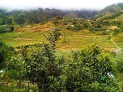
Kabayan is located at 16°37′N 120°50′E / 16.62°N 120.83°E, at the central-eastern section of Benguet. It is bounded by Buguias on the north, Kibungan on the north-west, Atok on the south-west, Bokod on the south, Kayapa on the southeast, and Tinoc on the north-east.
According to the Philippine Statistics Authority, the municipality has a land area of 242.69 square kilometres (93.70 sq mi) [15] constituting 8.76% of the 2,769.08-square-kilometre- (1,069.15 sq mi) total area of Benguet.
Barangays[]
Kabayan is politically subdivided into 13 barangays.[16]
| PSGC | Barangay | Population | ±% p.a. | |||
|---|---|---|---|---|---|---|
| 2020 [3] | 2010 [17] | |||||
| 141107001 | Adaoay | 3.9% | 621 | 670 | −0.73% | |
| 141107002 | Anchukey | 1.7% | 270 | 296 | −0.88% | |
| 141107003 | Ballay | 18.4% | 2,904 | 2,623 | 0.99% | |
| 141107004 | Bashoy | 14.0% | 2,207 | 1,597 | 3.17% | |
| 141107005 | Batan | 7.0% | 1,110 | 944 | 1.58% | |
| 141107009 | Duacan | 4.3% | 684 | 709 | −0.35% | |
| 141107010 | Eddet | 5.6% | 883 | 740 | 1.72% | |
| 141107012 | Gusaran | 9.0% | 1,429 | 1,330 | 0.70% | |
| 141107013 | Kabayan Barrio | 2.2% | 343 | 337 | 0.17% | |
| 141107014 | Lusod | 5.4% | 861 | 794 | 0.79% | |
| 141107016 | Pacso | 7.9% | 1,254 | 1,247 | 0.05% | |
| 141107017 | Poblacion (Central) | 11.5% | 1,816 | 1,567 | 1.43% | |
| 141107018 | Tawangan | 5.6% | 878 | 734 | 1.74% | |
| Total | 15,806 | 13,588 | 1.47% | |||
In the 2010 Census of Population and Housing, Barangay Anchukey would be the least populated barangay in the province of Benguet. [17]
Climate[]
| hideClimate data for Kabayan, Benguet | |||||||||||||
|---|---|---|---|---|---|---|---|---|---|---|---|---|---|
| Month | Jan | Feb | Mar | Apr | May | Jun | Jul | Aug | Sep | Oct | Nov | Dec | Year |
| Average high °C (°F) | 21 (70) |
22 (72) |
23 (73) |
25 (77) |
24 (75) |
24 (75) |
23 (73) |
23 (73) |
23 (73) |
23 (73) |
22 (72) |
21 (70) |
23 (73) |
| Average low °C (°F) | 13 (55) |
14 (57) |
15 (59) |
17 (63) |
18 (64) |
18 (64) |
18 (64) |
18 (64) |
18 (64) |
17 (63) |
15 (59) |
14 (57) |
16 (61) |
| Average precipitation mm (inches) | 38 (1.5) |
57 (2.2) |
77 (3.0) |
141 (5.6) |
390 (15.4) |
355 (14.0) |
426 (16.8) |
441 (17.4) |
426 (16.8) |
259 (10.2) |
97 (3.8) |
57 (2.2) |
2,764 (108.9) |
| Average rainy days | 10.4 | 12.1 | 15.4 | 20.4 | 26.7 | 27.1 | 28.7 | 28.0 | 26.4 | 19.9 | 14.1 | 12.3 | 241.5 |
| Source: Meteoblue (modeled/calculated data, not measured locally)[18] | |||||||||||||
Demographics[]
| Year | Pop. | ±% p.a. |
|---|---|---|
| 1903 | 22 | — |
| 1918 | 2,841 | +38.27% |
| 1939 | 4,190 | +1.87% |
| 1948 | 3,805 | −1.07% |
| 1960 | 5,869 | +3.68% |
| 1970 | 7,116 | +1.94% |
| 1975 | 8,363 | +3.29% |
| 1980 | 9,072 | +1.64% |
| 1990 | 10,306 | +1.28% |
| 1995 | 10,510 | +0.37% |
| 2000 | 12,344 | +3.51% |
| 2007 | 12,657 | +0.35% |
| 2010 | 13,588 | +2.62% |
| 2015 | 15,260 | +2.23% |
| 2020 | 15,806 | +0.69% |
| Source: Philippine Statistics Authority [19] [17] [20][21] | ||
In the 2020 census, Kabayan had a population of 15,806. [3] The population density was 65 inhabitants per square kilometre (170/sq mi).
Economy[]
| Poverty Incidence of Kabayan | |
| Source: Philippine Statistics Authority[22][23][24][25][26][27] | |
Tourism[]
Kabayan is best known for the antiquated centuries-old mummies and Mount Pulag, the third highest mountain in the Philippines. The Kabayan mummy burial caves are officially proclaimed Philippine National Cultural Treasures pursuant to Presidential Decree No. 374, and is under consideration as a World Heritage Site.[28] The mummified body of Apo Annu, a tribal leader, was stolen but recovered by an antique collector and was returned to the town. Archaeologists from various countries have visited the town to promote preservation of the mummies due to deterioration of the cadavers. The caves containing the cadavers of these mummies have been declared by as one of the "100 Most Endangered Sites" in the world.[29]
Mount Pulag is a destination for mountaineers, hikers, including picnickers. At its summit, the climbers can see the surroundings of the whole north Luzon.
Education[]
Public schools[]
As of 2014, Kabayan has 22 public elementary schools and 3 public secondary schools.[30][31][32]
References[]
- ^ Municipality of Kabayan | (DILG)
- ^ "2015 Census of Population, Report No. 3 – Population, Land Area, and Population Density" (PDF). Philippine Statistics Authority. Quezon City, Philippines. August 2016. ISSN 0117-1453. Archived (PDF) from the original on May 25, 2021. Retrieved July 16, 2021.
- ^ Jump up to: a b c d Census of Population (2020). "Cordillera Administrative Region (CAR)". Total Population by Province, City, Municipality and Barangay. PSA. Retrieved 8 July 2021.
- ^ https://psa.gov.ph/sites/default/files/City%20and%20Municipal-level%20Small%20Area%20Poverty%20Estimates_%202009%2C%202012%20and%202015_0.xlsx; publication date: 10 July 2019; publisher: Philippine Statistics Authority.
- ^ "Kabayan Mummies". Mummy Tombs. Archived from the original on 28 October 2000. Retrieved 17 September 2014.
- ^ Jump up to: a b c d "Municipality of Kabayan: History of Kabayan". Province of Benguet (official website). Archived from the original on 3 December 2014. Retrieved 4 November 2014.
- ^ Jump up to: a b c d e "Municipality of Kabayan, Benguet". Department of the Interior and Local Government - Cordillera Administrative Region. Archived from the original on 22 January 2016. Retrieved 4 November 2014.
- ^ Jump up to: a b Deem, James M. "Kabayan Mummies". Mummy Tombs. Archived from the original on 8 July 2015. Retrieved 4 November 2014.
- ^ Baucas, Biano L. (1998). A Brief History of Kabayan, Benguet. Benguet, Philippines: Hamada Publishing. p. 43. Retrieved 4 November 2014.
- ^ "Kabayan Mummy Caves". World Monuments Fund. Archived from the original on 26 May 2012. Retrieved 4 November 2014.
- ^ "Facts & Figures: Benguet Province". Philippine Statistics Authority - National Statistical Coordination Board - Cordillera Administrative Region. Archived from the original on 28 February 2016. Retrieved 9 October 2014.
- ^ Jump up to: a b c "History: Benguet Province". Province of Benguet (official website). Archived from the original on 19 October 2014. Retrieved 9 October 2014.
- ^ "Executive Order No. 42, s. 1963: Declaring Certain Municipal Districts in the Philippines as Municipalities". Official Gazette of the Republic of the Philippines. Retrieved 25 October 2014.
- ^ "Republic Act No. 4695: An Act Creating the Provinces of Benguet, Mountain Province, Ifugao and Kalinga-Apayao". Chan Robles Virtual Law Library. 18 June 1966. Archived from the original on 4 March 2016. Retrieved 12 December 2016.
- ^ "Province: Benguet". PSGC Interactive. Quezon City, Philippines: Philippine Statistics Authority. Retrieved 12 November 2016.
- ^ "Municipal: Kabayan, Benguet". PSGC Interactive. Quezon City, Philippines: Philippine Statistics Authority. Retrieved 8 January 2016.
- ^ Jump up to: a b c Census of Population and Housing (2010). "Cordillera Administrative Region (CAR)". Total Population by Province, City, Municipality and Barangay. NSO. Retrieved 29 June 2016.
- ^ "Kabayan: Average Temperatures and Rainfall". Meteoblue. Retrieved 21 March 2020.
- ^ Census of Population (2015). "Cordillera Administrative Region (CAR)". Total Population by Province, City, Municipality and Barangay. PSA. Retrieved 20 June 2016.
- ^ Censuses of Population (1903–2007). "Cordillera Administrative Region (CAR)". Table 1. Population Enumerated in Various Censuses by Province/Highly Urbanized City: 1903 to 2007. NSO.
- ^ "Province of Benguet". Municipality Population Data. Local Water Utilities Administration Research Division. Retrieved 17 December 2016.
- ^ "Poverty incidence (PI):". Philippine Statistics Authority. Retrieved 28 December 2020.
- ^ https://psa.gov.ph/sites/default/files/NSCB_LocalPovertyPhilippines_0.pdf; publication date: 29 November 2005; publisher: Philippine Statistics Authority.
- ^ https://psa.gov.ph/sites/default/files/2003%20SAE%20of%20poverty%20%28Full%20Report%29_1.pdf; publication date: 23 March 2009; publisher: Philippine Statistics Authority.
- ^ https://psa.gov.ph/sites/default/files/2006%20and%202009%20City%20and%20Municipal%20Level%20Poverty%20Estimates_0_1.pdf; publication date: 3 August 2012; publisher: Philippine Statistics Authority.
- ^ https://psa.gov.ph/sites/default/files/2012%20Municipal%20and%20City%20Level%20Poverty%20Estima7tes%20Publication%20%281%29.pdf; publication date: 31 May 2016; publisher: Philippine Statistics Authority.
- ^ https://psa.gov.ph/sites/default/files/City%20and%20Municipal-level%20Small%20Area%20Poverty%20Estimates_%202009%2C%202012%20and%202015_0.xlsx; publication date: 10 July 2019; publisher: Philippine Statistics Authority.
- ^ "Kabayan Mummy Burial Caves". Tentative Lists. UNESCO World Heritage Centre. Archived from the original on 25 May 2016. Retrieved 13 August 2013.
- ^ "The Kabayan Branch". National Museum of the Philippines. Archived from the original on 30 March 2016. Retrieved 13 August 2013.
- ^ "Masterlist of Public Elementary Schools for the School year 2012- 2013". Department of Education (Philippines), July 15, 2013. Archived from the original (XLSX) on 4 March 2016. Retrieved 28 December 2014.
- ^ Jump up to: a b "Masterlist of Secondary Schools (School Year 2013- 2014)". Department of Education (Philippines), 4 July 2013. Archived from the original (XLSX) on 1 July 2014. Retrieved 20 November 2014.
- ^ Jump up to: a b "Masterlist of Public Schools SY 2013-2014". Department of Education (Philippines), 22 October 2014. Archived from the original (XLSX) on 21 April 2016. Retrieved 28 December 2014.
External links[]
| Wikimedia Commons has media related to Kabayan, Benguet. |
| show Places adjacent to Kabayan, Benguet |
|---|
| hide | |
|---|---|
La Trinidad (capital) | |
| Municipalities | |
| Highly urbanized city |
|
| Barangays | |
| show Authority control |
|---|
- Municipalities of Benguet
- Populated places on the Agno River