Baoshan District, Shanghai
Baoshan
宝山区 Paoshan | |
|---|---|
 The mouth of the Huangpu River | |
 | |
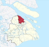 Baoshan in Shanghai | |
| Coordinates (Baoshan government): 31°24′19″N 121°29′23″E / 31.4054°N 121.4896°ECoordinates: 31°24′19″N 121°29′23″E / 31.4054°N 121.4896°E | |
| Country | People's Republic of China |
| Municipality | Shanghai |
| Area | |
| • Total | 424.58 km2 (163.93 sq mi) |
| Population (2018) | |
| • Total | 2,543,500 |
| • Density | 6,000/km2 (16,000/sq mi) |
| Time zone | UTC+8 (China Standard) |

| Baoshan | |||
|---|---|---|---|
| Traditional Chinese | 寶山區 | ||
| Simplified Chinese | 宝山区 | ||
| Postal | Paoshan | ||
| |||
![]() Baoshan District (help·info), is a suburban district of Shanghai. It has an area of 424.58 square kilometers (163.93 sq mi) and had a population of 1,905,000 at the time of the 2010 Chinese census.
Baoshan District (help·info), is a suburban district of Shanghai. It has an area of 424.58 square kilometers (163.93 sq mi) and had a population of 1,905,000 at the time of the 2010 Chinese census.
History[]
The area was the scene of heavy fighting during the Battle of Shanghai.[1]
Landmarks[]
The War of Resistance Memorial Park on Donglin Lu has a small museum with artifacts from the Second World War and a modern glass-and-steel pagoda.
The Wisdom Bay Industrial Park has the world's largest concrete 3D printed pedestrian bridge.[2]
Education[]
The main campus of Shanghai University is located in Baoshan District. One of several schools in the district, was founded by the famous educationalist from Nanjing, Tao Xingzhi. Shanghai Xingzhi High School and the High School Affiliated to Shanghai University are also located in the district.
Transport[]
Baoshan District is served by the Shanghai Metro. There are 3 lines from Baoshan to central Shanghai—Line 1, Line 3, and Line 7—which operate as subways, elevated rail, and light rail in different parts of the district. The 952B bus runs from Youyizhi Rd at Youyi Rd to People's Square in central Shanghai.
Ferries to Chongming Island operate from Wusong, Baoyang Rd, and Shidongkou. Ferries to Putuoshan are also available.
Economy[]
The district is home to Baosteel Group's original factory, still a major producer of iron and steel. Rovio Entertainment has its China offices in Baoshan District.[3] The (石洞口发电厂) is located along the Yangtze.
Government[]
Subdivisions[]
| Name | Chinese (S) | Hanyu Pinyin | Shanghainese Romanization | Population (2010)[4] | Area (km2) |
|---|---|---|---|---|---|
| 友谊路街道 | Yǒuyìlù Jiēdào | yoe gnij lu ka do | 136,814 | 10.45 | |
| Wusong Subdistrict | 吴淞街道 | Wúsōng Jiēdào | wu son ka do | 104,162 | 7.52 |
| 张庙街道 | Zhāngmiào Jiēdào | tzan mio ka do | 172,284 | 5.19 | |
| Luodian town | 罗店镇 | Luōdiàn Zhèn | lu ti tzen | 118,323 | 44.19 |
| town | 大场镇 | Dàchǎng Zhèn | da dzan tzen | 371,856 | 27.22 |
| town | 杨行镇 | Yángxíng Zhèn | yan raon tzen | 204,564 | 37.91 |
| town | 月浦镇 | Yuèpǔ Zhèn | yuq phu tzen | 139,328 | 47.34 |
| town | 罗泾镇 | Luōjīng Zhèn | lu cin tzen | 54,329 | 47.68 |
| town | 顾村镇 | Gùcūn Zhèn | ku tsen tzen | 240,185 | 41.66 |
| town | 高境镇 | Gāojìng Zhèn | ko cin tzen | 127,512 | 11.23 |
| town | 庙行镇 | Miàoxíng Zhèn | mio ran raon tzen | 89,615 | 5.96 |
| town | 淞南镇 | Sōngnán Zhèn | son neu tzen | 127,347 | 13.65 |
| 宝山城市工业园区 | Bǎoshān Chéngshì Gōngyè Yuánqū | po se zen zy kon gniq yeu chiu | 18,567 | 4.35 |
Transportation[]
Metro[]
Baoshan is currently served by three metro lines operated by Shanghai Metro:
- Line 1 - Tonghe Xincun, Hulan Road, Gongfu Xincun, Bao'an Highway, West Youyi Road, Fujin Road
- Line 3 - West Yingao Road, South Changjiang Road, Songfa Road, Zhanghuabang, Songbin Road, Shuichan Road, Baoyang Road, Youyi Road, Tieli Road, North Jiangyang Road
- Line 7 - Meilan Lake, Luonan Xincun, Panguang Road, Liuhang, Gucun Park, Qihua Road, Shanghai University, Nanchen Road, Shangda Road, Changzhong Road, Dachang Town, Xingzhi Road, Dahuasan Road
See also[]
References[]
- ^ Sun, Lianggang. "Shanghai 1937 – Where World War II Began". 上海1937–第二次世界大战开始的地方. Retrieved 2020-11-21.
- ^ Dixon, Emily (2019-01-24). "The world's longest 3D-printed concrete bridge is finished". CNN Style. Retrieved 2019-01-24.
- ^ Rovio China Archived November 12, 2012, at the Wayback Machine. Accessed 10 Nov 2012.
- ^ Census Office of the State Council of the People's Republic of China; Population and Employment Statistics Division of the National Bureau of Statistics of the People's Republic of China (2012). 中国2010人口普查分乡、镇、街道资料 (1 ed.). Beijing: China Statistics Print. ISBN 978-7-5037-6660-2.
Further reading[]
| Wikimedia Commons has media related to Baoshan District. |
- "Baoshan District". Encyclopedia of Shanghai. Shanghai People's Government. 2010. Archived from the original on 2013-03-02.
| show Shanghai |
|---|

| show Authority control |
|---|
This Shanghai location article is a stub. You can help Wikipedia by . |
- Baoshan District, Shanghai
- Eastern China geography stubs
- Shanghai stubs