Batayporã
Batayporã | |
|---|---|
 Flag  Coat of arms | |
 Location in Mato Grosso do Sul state | |
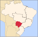
 Batayporã Location in Brazil | |
| Coordinates: 22°17′42″S 53°16′15″W / 22.29500°S 53.27083°WCoordinates: 22°17′42″S 53°16′15″W / 22.29500°S 53.27083°W | |
| Country | Brazil |
| Region | Central-West |
| State | Mato Grosso do Sul |
| Area | |
| • Total | 1,828 km2 (706 sq mi) |
| Population (2020 [1]) | |
| • Total | 11,349 |
| • Density | 6.2/km2 (16/sq mi) |
| Time zone | UTC-04:00 (BRT-1) |
| • Summer (DST) | UTC-03:00 (BRST-1) |

Batayporã is a municipality located in the Brazilian state of Mato Grosso do Sul. Its population was 11,349 (2020) and its area is 1,828 km².
The town has some residential developments, but it is surrounded by agricultural land. It is located south of Anaurilândia at the junction of MS-395 the MS-134 (BR376), paved single lane highways.
Other towns in Brazil linked to Batayporã:
- Mariápolis
- Bataguassu
- Batatuba
- Anaurilândia
References[]
| show |
|---|
| Authority control: National libraries |
|---|
This Mato Grosso do Sul, Brazil location article is a stub. You can help Wikipedia by . |
Categories:
- Municipalities in Mato Grosso do Sul
- Bata Corporation
- Mato Grosso do Sul geography stubs