Beaulieu-sous-Parthenay
Beaulieu-sous-Parthenay | |
|---|---|
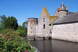 The château in Beaulieu sous Parthenay | |
show Location of Beaulieu-sous-Parthenay | |
 Beaulieu-sous-Parthenay | |
| Coordinates: 46°34′36″N 0°14′00″W / 46.5767°N 0.2333°WCoordinates: 46°34′36″N 0°14′00″W / 46.5767°N 0.2333°W | |
| Country | France |
| Region | Nouvelle-Aquitaine |
| Department | Deux-Sèvres |
| Arrondissement | Parthenay |
| Canton | La Gâtine |
| Government | |
| • Mayor (2020–2026) | Francine Chausseray[1] |
| Area 1 | 26.72 km2 (10.32 sq mi) |
| Population (Jan. 2018)[2] | 669 |
| • Density | 25/km2 (65/sq mi) |
| Time zone | UTC+01:00 (CET) |
| • Summer (DST) | UTC+02:00 (CEST) |
| INSEE/Postal code | 79029 /79420 |
| Elevation | 143–228 m (469–748 ft) (avg. 257 m or 843 ft) |
| 1 French Land Register data, which excludes lakes, ponds, glaciers > 1 km2 (0.386 sq mi or 247 acres) and river estuaries. | |


Beaulieu-sous-Parthenay is a commune in the Deux-Sèvres department in the Nouvelle-Aquitaine region in western France.
See also[]
References[]
- ^ "Répertoire national des élus: les maires". data.gouv.fr, Plateforme ouverte des données publiques françaises (in French). 2 December 2020.
- ^ "Populations légales 2018". INSEE. 28 December 2020.
| Wikimedia Commons has media related to Beaulieu-sous-Parthenay. |
This Deux-Sèvres geographical article is a stub. You can help Wikipedia by . |
Categories:
- Communes of Deux-Sèvres
- Deux-Sèvres geography stubs