Ensigné
Ensigné | |
|---|---|
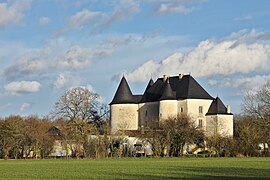 The commandry | |
show Location of Ensigné | |
 Ensigné | |
| Coordinates: 46°05′19″N 0°14′35″W / 46.0886°N 0.2431°WCoordinates: 46°05′19″N 0°14′35″W / 46.0886°N 0.2431°W | |
| Country | France |
| Region | Nouvelle-Aquitaine |
| Department | Deux-Sèvres |
| Arrondissement | Niort |
| Canton | Mignon-et-Boutonne |
| Government | |
| • Mayor (2020–2026) | Bernard Belaud[1] |
| Area 1 | 20.30 km2 (7.84 sq mi) |
| Population (Jan. 2018)[2] | 287 |
| • Density | 14/km2 (37/sq mi) |
| Time zone | UTC+01:00 (CET) |
| • Summer (DST) | UTC+02:00 (CEST) |
| INSEE/Postal code | 79111 /79170 |
| Elevation | 55–149 m (180–489 ft) (avg. 413 m or 1,355 ft) |
| 1 French Land Register data, which excludes lakes, ponds, glaciers > 1 km2 (0.386 sq mi or 247 acres) and river estuaries. | |


Ensigné is a commune in the Deux-Sèvres department in the Nouvelle-Aquitaine region in western France.
Geography[]
The surrounding countryside is densely wooded. The village is close to the forest of Ensigné and of Aulnay.
The kindergarten and primary school have been merged with those of Asnières-en-Poitou and Paizay-le-Chapt, none of the three individual villages having a population above 300 by the start of the twenty-first century.
History[]
The history of the village is closely linked to that of the Knights Templar. Ensigné contains a Templar command post comprising fortifications, a chapel and a castle. Today the site is privately owned: the castle itself is in a ruined condition, but two separate properties have been created from the part including the former chapel.
See also[]
References[]
- ^ "Répertoire national des élus: les maires". data.gouv.fr, Plateforme ouverte des données publiques françaises (in French). 2 December 2020.
- ^ "Populations légales 2018". INSEE. 28 December 2020.
| Wikimedia Commons has media related to Ensigné. |
This Deux-Sèvres geographical article is a stub. You can help Wikipedia by . |
- Communes of Deux-Sèvres
- Deux-Sèvres geography stubs