Beauraing
This article needs additional citations for verification. (March 2013) |
Beauraing | |
|---|---|
 Beauraing centre | |
 Flag  Coat of arms | |
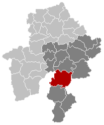
 Beauraing Location in Belgium
show Location of Beauraing in Namur province | |
| Coordinates: 50°6.55′N 04°57.4′E / 50.10917°N 4.9567°ECoordinates: 50°6.55′N 04°57.4′E / 50.10917°N 4.9567°E | |
| Country | Belgium |
| Community | French Community |
| Region | |
| Province | Namur |
| Arrondissement | Dinant |
| Government | |
| • Mayor | Jean-Claude Maene (LDM) |
| • Governing party/ies | LDM - MRB |
| Area | |
| • Total | 174.55 km2 (67.39 sq mi) |
| Population (2018-01-01)[1] | |
| • Total | 9,160 |
| • Density | 52/km2 (140/sq mi) |
| Postal codes | 5570-5574, 5576 |
| Area codes | 082 |
| Website | www.beauraing.be |

Beauraing (French pronunciation: [bo.ʁɛ̃]; Walloon: Biarin) is a city and municipality of Wallonia located in the Belgian province of Namur. On January 1, 2006, Beauraing had a total population of 8,344. The total area is 174.55 km², giving a population density of 48 inhabitants per km².
The municipality of Beauraing was created in 1977 from the fusion of Beauraing, Baronville, Dion, Felenne, Feschaux, Focant, Froidfontaine, Honnay, Javingue, Martouzin-Neuville, Pondrôme, Vonêche, Wancennes, Wiesme and Winenne.
Beauraing is a place of pilgrimage for Catholics ever since five children and young adults reported 33 apparitions of the Blessed Virgin Mary between November 29, 1932, and January 3, 1933. The sobriquet applied to these apparitions is Our Lady of Beauraing, the Virgin of the Golden Heart. The apparitions are among those which are officially sanctioned by the Church.
See also[]
References[]
- ^ "Wettelijke Bevolking per gemeente op 1 januari 2018". Statbel. Retrieved 9 March 2019.
External links[]
![]() Media related to Beauraing at Wikimedia Commons
Media related to Beauraing at Wikimedia Commons
| show Places adjacent to Beauraing |
|---|
| show Municipalities in the province of Namur, Wallonia |
|---|

| show Authority control |
|---|
This Namur Province location article is a stub. You can help Wikipedia by . |
- Cities in Wallonia
- Municipalities of Namur (province)
- Shrines to the Virgin Mary
- Namur geography stubs