Beinan, Taitung
Coordinates: 22°47′N 121°07′E / 22.783°N 121.117°E

Beinan Township 卑南鄉 | |
|---|---|
 | |
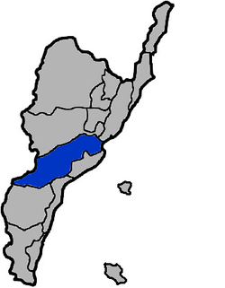 Beinan Township in Taitung County | |
| Location | Taitung County, Taiwan |
| Area | |
| • Total | 413 km2 (159 sq mi) |
| Population (July 2018) | |
| • Total | 17,322 |
| • Density | 42/km2 (110/sq mi) |
Beinan Township or Peinan Township (Chinese: 卑南鄕; pinyin: Bēinán Xiāng; Pe̍h-ōe-jī: Pi-lâm) is a rural township in Taitung County, Taiwan. It has a population of 17,435 as of November 2017.[1] It is home to the Puyuma and Rukai peoples.
Name[]
This southeastern region of Taiwan was originally dominated by the Puyuma people. The township is named in Puyuma in honor of chief Pinara.[2]
In Dutch Formosa, the Dutch called the township Pimala. During Qing rule, access to the area was prohibited.
History[]
In 1875, Pi-lam Subprefecture (卑南廳) was established. During the period of Japanese rule, Pinan Village (卑南庄) was established under Taitō District, Taitō Prefecture. After the handover of Taiwan from Japan to the Republic of China in 1945, Beinan was established as a rural township of Taitung County.
Geography[]


The northeast portion of the township is part of the Huatung Valley.
Administrative divisions[]
The township comprises 13 villages: Binlang, Chulu, Fushan, Fuyuan, Jiafong, Liji, Lijia, Meinong, Mingfong, Taian, Taiping, Tunghsing and Wenkuan.

Tourist attractions[]
- Baiyu Waterfall
- Chu Lu Ranch[3]
- Jhihben National Forest Recreation Area
- Cingjue Temple
- Taromak Monument
- Yuan Sen Applied Botanical Garden
- Jhihben Hot Spring[4]
Transportation[]

Beinan Township is accessible from Shanli Station of the Taiwan Railways.
Notable natives[]
- A-mei, singer and songwriter
- Lin Shu-ling, activist
References[]
- ^ "本所月戶數人口數統計(含臺東市、卑南鄉、綠島鄉、蘭嶼鄉(表1)". tth.taitung.gov.tw (in Chinese). 16 October 2012. Retrieved 1 January 2018.
- ^ "Beinan Township". Taitung County Govt. Archived from the original on 2017-11-07. Retrieved 15 July 2016.
- ^ "Chulu Ranch". Tour.taitung.gov.tw. Archived from the original on 2014-05-25. Retrieved 2014-05-14.
- ^ "East Rift Valley National Scenic Area::PDA". Erv-nsa.gov.tw. Archived from the original on 2013-10-29. Retrieved 2014-05-14.
External links[]
| Wikivoyage has a travel guide for Beinan. |
| Wikimedia Commons has media related to Beinan Township, Taitung. |
| show Cities and townships of Taitung County |
|---|

| Authority control |
|
|---|
- Townships in Taitung County
- Taiwan placenames originating from Formosan languages