Wutai, Pingtung
Coordinates: 22°45′N 120°44′E / 22.75°N 120.73°E

Wutai Township 霧臺鄉 | |
|---|---|
 Wutai Village | |
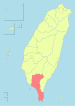
 Wutai Township in Pingtung County | |
| Location | Pingtung County, Taiwan |
| Area | |
| • Total | 279 km2 (108 sq mi) |
| Population (July 2018) | |
| • Total | 3,383 |
| • Density | 12/km2 (31/sq mi) |
Wutai Township (Chinese: 霧臺鄉; pinyin: Wùtái Xiāng; Rukai language: Vedai) is a mountain indigenous township in Pingtung County, Taiwan. It has a population total of 3,435 and an area of 278.80 square kilometres (107.65 sq mi).
History[]
During the Japanese era, Wutai was grouped with modern-day Sandimen Township and Majia Township as "Aboriginal Areas" (Japanese: 蕃地), which was governed under Heitō District, Takao Prefecture.
Demographics[]
The township is mainly inhabited by the Rukai people.[1]
Administrative divisions[]
The township comprises six villages: Ali, Dawu, Haocha, Jiamu, Jilou and Wutai.
Tourist attractions[]
- Guchuan Bridge
- Kucapungane, an ancient Rukai village with houses built of shale slabs[2]
References[]
- ^ "The humanity of Indigenous peoples". Pingtung County Government.
- ^ Chung, Jake (17 October 2015). "Rukai village included on list of world cultural sites". Taipei Times. p. 1.
External links[]
| Wikimedia Commons has media related to Wutai Township, Pingtung County. |
| show Cities and townships of Pingtung County |
|---|
| Authority control |
|
|---|
This article about a location in Taiwan is a stub. You can help Wikipedia by . |
Categories:
- Taiwan placenames originating from Formosan languages
- Townships in Pingtung County
- Taiwan geography stubs