Su'ao
Su'ao Township
蘇澳鎭 Suō, Su-ao, Suao | |
|---|---|
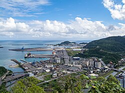 Port in Su'ao Township | |
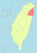
 Location of Suao in Yilan | |
| Coordinates: 24°36′N 121°51′E / 24.600°N 121.850°ECoordinates: 24°36′N 121°51′E / 24.600°N 121.850°E | |
| Country | Taiwan |
| County | Yilan |
| Area | |
| • Total | 89.01 km2 (34.37 sq mi) |
| Population (December 2014) | |
| • Total | 41,018 |
| Time zone | UTC+8 (Chungyuan Standard Time Zone) |
| Postal code | 270 |
| Website | www |


Su'ao Township (Chinese: 蘇澳鎭; pinyin: Sū'ào Zhèn; Wade–Giles: Su1-ao4 Chen4; Pe̍h-ōe-jī: So͘-ò), alternately romanized as Su-ao, is located in southern Yilan County, Taiwan, is an urban township that is famous for its seafood restaurants and cold springs.[1] It is a terminus of National Highway No. 5, the Su'ao-Hualien Express Way, and the North-Link Line of the Taiwan Railway Administration. It also has two large harbors: Su'ao Port, a multi-function seaport that also houses a naval base; and Nanfang-ao Port, a major fishing port of Taiwan.
History[]
Japanese rule[]

During Japanese rule, the area was established as Suō Town (蘇澳街), Suō District, Taihoku Prefecture.[2]
Post-war[]
After World War II, the town was converted to a township under Taipei County. In 1950, the township was put under the newly established Yilan County.[2]
Climate[]
| showClimate data for Su'ao |
|---|
Demographics[]
As of December 2016, Su'ao had 14,109 households and a total population of 40,493, including 19,877 females and 20,616 males.[3]
Villages[]
The township comprises 26 villages: Aiding, Cunren, Dingliao, Gangbian, Longde, Nanan, Nancheng, Nanjian, Nanning, Nanqiang, Nanxing, Nanzheng, Shengai, Shenghu, Subei, Sunan, Sutung, Suxi, Tungao, Xincheng, Yongchun, Yongguang, Yongle, Yongrong, Zhangan and Zhaoyang.[3]
Tourist attractions[]

- Coral Museum
- Neipi Beach
- Su'ao Cold Spring
- Su'ao Fortress
- Tofu Cape
- Wulaokeng Scenic Area
- Zhu Dayu Culture Museum
Transportation[]

Notable people[]
- Chang Chen-yue, singer
- Cheng Jei-cheng, Minister of Education (2008-2009)
- Chang Yung-fa, founder of Evergreen Group
Gallery[]

View of the Port of Su'ao

Port of Su'ao at night
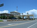
Administrative building in the Port of Su'ao

Neipi Harbor

View of Neipi Beach


References[]
- ^ "2015 Su'ao Cold Spring Festival opens on Friday". focustaiwan.tw. Focus Taiwan News Channel. 16 July 2015. Retrieved 30 January 2017.
- ^ Jump up to: a b 歷史沿革 [Historical evolution]. suao.gov.tw (in Chinese). Suao Township Office. Retrieved 30 January 2017.
- ^ Jump up to: a b 蘇澳鎮人口統計 [Su'ao Township Population Statistics]. e-land.gov.tw (in Chinese). Yilan County Government. December 2016. Retrieved 30 January 2017.[permanent dead link]
External links[]
| Wikimedia Commons has media related to Suao Township, Yilan. |
| Wikivoyage has a travel guide for Suao. |
- Official website
 (in Chinese)
| show Cities and townships of Yilan County |
|---|
This article about a location in Taiwan is a stub. You can help Wikipedia by . |
- Port cities and towns in Taiwan
- Townships in Yilan County, Taiwan
- Taiwan geography stubs