Bijelo Brdo, Croatia
Bijelo Brdo
| |
|---|---|
Village (Selo) | |
       | |
 Bijelo Brdo | |
| Coordinates: 45°31′02″N 18°52′15″E / 45.5172°N 18.8708°E | |
| Country | |
| County | |
| Municipality | Erdut |
| Government | |
| • Body | Local Committee |
| Population (2011) | |
| • Total | 1,961 |
| Demonym(s) | Bjelobrđanin (♂) Bjelobrđanka (♀) (per grammatical gender) |
| Time zone | UTC+1 (CET) |
| • Summer (DST) | UTC+2 (CEST) |
| Official languages | Croatian, Serbian[1] |


Bijelo Brdo (Serbian Cyrillic: Бијело Брдо,[1] Hungarian: Darnó, German: Wellibardo) is a village in the Erdut municipality in eastern Croatia. It is connected by the D213 road and by R202 railway. It has a total of 1,961 inhabitants (2011).
Geography[]
The village is situated 15 km east from Osijek, in the Slavonia region on the banks of the Stara Drava branch, in the micro-region of , at an altitude of 93m above sea level. It covers an area of 36.64 km2.
History[]
Bijelo Brdo is important for archeological findings from the Bronze Age (Transdanubian cultural group) and two medieval cemeteries: one Avar-Slavic from VII-IX. century and another from X-XI. century, which became the eponymous site of the Bijelo Brdo culture. Before the Ottoman rule, the village was once called Trnovac, the neighboring Hungarians called it Dorno. During the Ottoman rule, the population from upper Podrinje and Polimlje settled there. During the Vienna War (1683–1699), at the time of the Turkish withdrawal the settlement was destroyed and the inhabitants fled to Bosnia. A considerable number of Serbs, in the almost desolate Trnovac, settled in the time of the Great Migrations of the Serbs under Arsenije III Čarnojević. In 1706, the village numbered 63 houses and in that year became part of a Dalj estate.[2][3] The colonization of Slavonia was carried out in a systematic fashion through centuries but particularly during the period of WWII. Among people inhabiting poor areas Slavonia was famed as a promised land which could feed large numbers of people, where there was a lot of fertile land and favorable living conditions.[4]
Culture[]
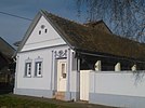
- Church of St. Nicholas, built between 1764 and 1809, reconstructed in 1996.
Demographics[]
This section does not cite any sources. (August 2015) |
The 2011 census had a total of 1,961 inhabitants. The 2001 census had a total of 2,119 inhabitants in 720 households. 1991 census, a total of 2,400 inhabitants, out of which Serbs 1,941 (80.87%), Croats 217 (9.04%), Yugoslavs 97 (4.04%), and other smaller communities.
Sport[]
- NK BSK Bijelo Brdo
- Bijelo Brdo Chess Club
Notable people[]
- Kuzman Stanić (1825–1898), parish priest of Timişoara
- Vasilije Trbić (1881–1962), Serbian Chetnik commander in Macedonia
References[]
- ^ Jump up to: a b c Government of Croatia (October 2013). "Peto izvješće Republike Hrvatske o primjeni Europske povelje o regionalnim ili manjinskim jezicima" (PDF) (in Croatian). Council of Europe. p. 36. Retrieved 30 November 2016.
- ^ "Bijelo Brdo | Općina Erdut". Retrieved 2019-08-16.
- ^ "Bijelo Brdo | Hrvatska enciklopedija". www.enciklopedija.hr. Retrieved 2019-08-16.
- ^ Balta, Ivan (2001-10-19). "Kolonizacija u Slavoniji od početka XX. stoljeća s posebnim osvrtom na razdoblje 1941.-1945. godine". Radovi Zavoda za povijesne znanosti HAZU u Zadru (in Croatian) (43): 459–478. ISSN 1330-0474.
| show Erdut Municipality |
|---|


Coordinates: 45°31′03″N 18°52′23″E / 45.51750°N 18.87306°E
This Osijek-Baranja County geography article is a stub. You can help Wikipedia by . |
- Populated places in Osijek-Baranja County
- Osijek-Baranja County geography stubs