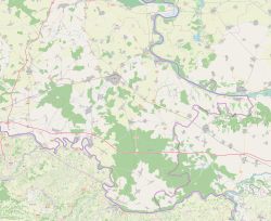
Bobota, Croatia
Bobota
| |
|---|---|
Village (Selo) | |
 | |
 | |
 Bobota | |
| Coordinates: 45°23′45″N 18°51′19″E / 45.395934°N 18.855382°E | |
| Country | |
| Region | Slavonia (Podunavlje) |
| County | |
| Municipality | Trpinja |
| Government | |
| • Body | Local Committee |
| Population (2011)[3] | |
| • Total | 1,491 |
| Demonym(s) | Boboćanin (♂) Boboćanka (♀) (per grammatical gender) |
| Time zone | UTC+1 (CET) |
| • Summer (DST) | UTC+2 (CEST) |
| Postal code | 32 225 Bobota |
| Vehicle registration | VU |
| Official languages | Croatian, Serbian[2] |


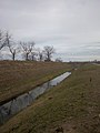
Bobota (Serbian Cyrillic: Бобота)[4] is a village in the Municipality of Trpinja in Vukovar-Syrmia County in eastern Croatia. Regional Bobota Canal, the first major water management project in modern-day Croatia in the post-Roman Empire period, was named after the village.
According to 2011 Census Bobota had a population of 1,491 inhabitants.[3] Bobota is centrally located within the municipality and is its largest settlement with total population just marginally ahead of Trpinja. The village is located south of the D2 road and part of the Osijek Airport plot, including a part of the runway is within its cadastral boundaries. The village is also located centrally in the triangle between the nearby cities of Osijek, Vukovar and Vinkovci.
Name[]
Villages of Trpinja, Bobota and Vera share the common legend about the origin of their names. According to the legend, the ancestors of today's inhabitants of villages, who settled at the time of the Great Serb Migrations under Arsenije III Čarnojević, were called Bobe. According to this legend, they fled from the Ottoman Empire conquests of Balkan as they wanted to preserve their religious freedom.
This legendary religious commitment and orthodoxy was coined in the local phrase Bobe endured for the faith or originally in Serbian Bobe trpiše za veru. The family name of 'Bobe' was used as the basis for the name of Bobota, the word 'endured' (Serbo-Croatian: trpiti) the name of Trpinja was created and from the word of faith (Serbian: vera) the name of Vera was created.[5]
Geography[]
Bobota, just slightly ahead of Trpinja, is the largest settlement in the municipality. Bobota is surrounded by Pačetin to the south, Ćelije to the west, Vera to the north and Trpinja, Lipovača and Bršadin to the east. Fertile intensive agricultural land and lowland forests are the main characteristics of the landscape. The Bobota Canal passes just north of the village separating a small part of it from the rest of the village.
History[]

The earliest historical record of Bobota dates back to 1269.[6] The oldest book about Bobota was published in 1750.[7]
In the first years following the World War II in Yugoslavia and before 1948 Tito–Stalin split the new Yugoslavia implemented a number of policies copied from the Soviet Union including some aspects of collectivization in the Soviet Union. Rural resistance to this policy led to an incident in Bobota in 1945 when an anonymous humorous graffiti appeared in the village subsequently described by new authorities as an "enemy act by kulak elements".[8] The inscription, which rhyme in original language, stated "Kralju Petre, dođi nam do žetve, jer nam Tito odnese sve žito" or in English "King Peter, come before our harvest, because Tito took away all of our grain".[8]
Population[]
This section needs expansion. You can help by . (December 2011) |
Historical population 1857-2001[9]

Serbs of Croatia constitute absolute majority of the local population.
Economy[]
This section needs expansion. You can help by . (December 2011) |
Agriculture is important source of economic revenue.
Education[]
Kindergarten Liliput[]
Local Liliput Kindergarten was formally registered on 29 March 1999.[10] Its center is located in Bobota, with additional two branch kindergartens in Bršadin and Trpinja.[10] Kindergarten is named after fictional island nation of Lilliput from the Gulliver's Travels written by the Anglo-Irish writer and clergyman Jonathan Swift. Since institution operate in villages where Serbs of Croatia constitute majority, it offers its program in Serbian with additional mandatory learning of Croatian.[10]
Primary school[]

Local public Primary School in Bobota provides education up to eighth grade. Institution offer classes in Serbian and Cyrillic. School also operate four branch schools in Pačetin, Vera, Klisa, and Ludvinci.[11] Those branch schools offer classes for pupils up to the fourth grade while higher grades student have to attend classes in Bobota. The school building in Bobota consists of two parts, one of which was built in 1928 and the other in 1975.[11] During the school year 2006/2007 new sports hall was built.[11] The school building has 8 classrooms, 7 specialized cabinets, two offices, library, staff room, toilets and central heating.[11] Furniture and educational equipment do not meet all standards due to deterioration and the lack of teaching resources.[11] School Library has in its possession approximately 5,000 items (books, CD-s, magazines).[12]
Associations and Institutions[]
In the village exist a volunteer fire department Bobota.[13]
Sport[]
The village has a football team, called


Bobota Canal


See also[]
References[]
| Wikimedia Commons has media related to Bobota, Croatia. |
- ^ "Statut Općine Trpinja" (PDF). Retrieved 25 May 2015.
- ^ Jump up to: a b Government of Croatia (October 2013). "Peto izvješće Republike Hrvatske o primjeni Europske povelje o regionalnim ili manjinskim jezicima" (PDF) (in Croatian). Council of Europe. p. 36. Retrieved 30 November 2016.
- ^ Jump up to: a b "Population by Age and Sex, by Settlements, 2011 Census: Bobota". Census of Population, Households and Dwellings 2011. Zagreb: Croatian Bureau of Statistics. December 2012.
- ^ "Minority names in Croatia: Registar Geografskih Imena Nacionalnih Manjina Republike Hrvatske" (PDF). Archived from the original (PDF) on 2013-10-29. Retrieved 2013-03-08.
- ^ http://www.trpinja.hr/index.php?option=com_content&view=article&id=13&Itemid=26&lang=hr[permanent dead link]
- ^ "Archived copy". Archived from the original on 2012-04-25. Retrieved 2013-03-30.CS1 maint: archived copy as title (link)
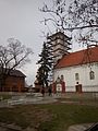
- ^ "Pravoslavni hramovi u Boboti i Bijelom Brdu". Srbi.hr, Joint Council of Municipalities. 20 April 2018. Retrieved 3 September 2021.
- ^ Jump up to: a b Ivo Goldstein, Slavko Goldstein (2020). Tito [Tito] (in Croatian). Zagreb: Profil. p. 493. ISBN 978-953-313-750-6.
- ^ Naselja i stanovništvo Republike Hrvatske 1857.-2001., www.dzs.hr Archived May 5, 2012, at the Wayback Machine
- ^ Jump up to: a b c "Općina Trpinja-Dječji vrtić "Liliput-Trpinja"-O nama". Retrieved 5 August 2015.
- ^ Jump up to: a b c d e "Osnovna škola Bobota-o školi". Retrieved 2 August 2015.
- ^ "Osnovna škola Bobota-Knjižnica". Retrieved 2 August 2015.
- ^ "Archived copy" (PDF). Archived from the original (PDF) on 2012-04-30. Retrieved 2011-10-15.CS1 maint: archived copy as title (link)

| show Trpinja Municipality |
|---|

| show Places adjacent to Bobota, Croatia |
|---|
Coordinates: 45°25′19″N 18°51′22″E / 45.42194°N 18.85611°E
- Populated places in Vukovar-Syrmia County
- Joint Council of Municipalities
- Populated places in Syrmia
- Serb communities in Croatia