Blackbutt, New South Wales
| Blackbutt Shellharbour, New South Wales | |||||||||||||||
|---|---|---|---|---|---|---|---|---|---|---|---|---|---|---|---|
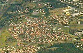 Aerial view from the east. | |||||||||||||||
 Blackbutt | |||||||||||||||
| Coordinates | 34°34.3′S 150°50.3′E / 34.5717°S 150.8383°ECoordinates: 34°34.3′S 150°50.3′E / 34.5717°S 150.8383°E | ||||||||||||||
| Population | 3,301 (2016 census)[1] | ||||||||||||||
| Postcode(s) | 2529 | ||||||||||||||
| LGA(s) | City of Shellharbour | ||||||||||||||
| Region | Illawarra | ||||||||||||||
| County | Camden | ||||||||||||||
| Parish | Terragong | ||||||||||||||
| State electorate(s) | Shellharbour | ||||||||||||||
| Federal division(s) | Whitlam | ||||||||||||||
| |||||||||||||||

Blackbutt is a southern suburb of Shellharbour, New South Wales, Australia. The eastern half of the suburb is occupied by the Blackbutt Forest Reserve.
References[]
- ^ Australian Bureau of Statistics (27 June 2017). "Blackbutt (State Suburb)". 2016 Census QuickStats. Retrieved 14 July 2017.

This Shellharbour geography article is a stub. You can help Wikipedia by . |
Categories:
- Suburbs of Wollongong
- City of Shellharbour
- Illawarra region geography stubs