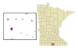
Blue Earth, Minnesota
Blue Earth | |
|---|---|
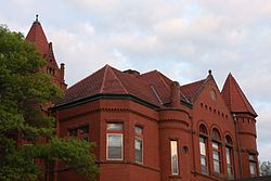 Faribault County Courthouse in Blue Earth | |
| Nickname(s): Beyond the Valley of the Jolly Green Midget | |
| Motto(s): Earth so rich the city grows! | |
 | |
| Coordinates: 43°38′25″N 94°5′55″W / 43.64028°N 94.09861°W | |
| Country | United States |
| State | Minnesota |
| County | Faribault |
| Government | |
| • Type | Mayor – Council |
| • Mayor | Tanner O'Rourke |
| Area | |
| • Total | 3.34 sq mi (8.65 km2) |
| • Land | 3.25 sq mi (8.41 km2) |
| • Water | 0.09 sq mi (0.24 km2) |
| Elevation | 1,089 ft (332 m) |
| Population | |
| • Total | 3,353 |
| • Estimate (2019)[3] | 3,108 |
| • Density | 957.49/sq mi (369.67/km2) |
| Time zone | UTC-6 (Central (CST)) |
| • Summer (DST) | UTC-5 (CDT) |
| ZIP code | 56013 |
| Area code(s) | 507 |
| FIPS code | 27-06688 |
| GNIS feature ID | 0640284[4] |
| Website | www.becity.org |

Blue Earth is a city in Faribault County, Minnesota, United States, at the confluence of the east and west branches of the Blue Earth River. The population was 3,353 at the 2010 census.[5] It is the county seat of Faribault County.[6] It is home to a statue of the Jolly Green Giant. Additionally, Interstate 90 is centered on Blue Earth, as the east and west construction teams met here in 1978. As a tribute, there is a golden stripe of concrete on the interstate near Blue Earth. This draws an analogy to the golden spike set in the first transcontinental railroad.
History[]
Blue Earth was platted in 1856.[7] The city took its name from the Blue Earth River which surrounds the town.[8] The river was given the Dakota name "Mahka-to" (meaning Blue Earth) for the blue-black clay found in the river banks.[9]
A post office has been in operation at Blue Earth since 1856.[10]
Attractions and community achievements[]
The Jolly Green Giant statue attracts over 10,000 visitors a year. In July 2007, the Blue Earth City Council approved space for a Green Giant memorabilia museum. Lowell Steen, of Blue Earth, has collected thousands of Green Giant items and will permanently loan them to the museum.[11]
Steinberg Nature Park is a 33-acre (13.35 ha) park located east of Blue Earth on County Road 16. The park has a half-mile (0.8 km) trail and a picnic shelter.[12]
Prior to football playoffs the Minneapolis Star Tribune had a Coaches Poll who voted each week for the Best Football Team in the State.[citation needed] In 1964, 1965 and 1966, the Blue Earth High School Bucs were rated #1 for 3 consecutive years holding many of their opponents to negative total yards. In 1972, the football team went 9-1 and played in the first state football playoffs and lost. The 1990 football team finished third in Minnesota for Class A. On November 24, 2012, the 2012 football team won the division 3A championship by defeating Rochester Lourdes High School by a score of 30–7.
The Blue Earth Bucs high school wrestling program has the second-most individual state champions on record in Minnesota with 50.[citation needed]
On Sept. 10–12, 1999, The Order of the Arrow (OA), a group within the Boy Scouts of America, held its Section C-1A Conclave in Blue Earth. Seven OA Lodges, representing councils from Iowa, Minnesota, North Dakota and South Dakota, attended the event.
Architecture[]
Blue Earth is home to many examples of Midwestern architecture, including:
Faribault County Courthouse – completed in December 1892 at a cost of over $70,000. The architect for the courthouse was C.A. Dunham of Burlington, Iowa and the contractor was S.J. Hoban from St. Paul. The style of the courthouse is Richardsonian Romanesque. Stone used in the construction of the courthouse was transported from Kasota, Minnesota to Blue Earth by horse and wagon and rail. Most of the sand used in the mortar was from the Blue Earth river bottom and thoroughly washed. The pillars on the front of the building are of polished granite. There are ledges on all four sides of the tower that are of solid stone of unknown weights of several ton each.[13]
Episcopal Church of the Good Shepherd – 1872
First Presbyterian Church — constructed in 1897 at a cost of $12,622.75. Designed by Kinney and Orth, architects from Austin, Minnesota. The architecture is Romanesque Revival in the arched windows, Gothic Revival in the steeples and gables, and medieval in the towers.[14]
Salem Evangelical Church – This English country Gothic structure was completed in 1942. Designed by Bard & Vanderbilt of Minneapolis, Minnesota.
Geography[]
According to the United States Census Bureau, the city has a total area of 3.36 square miles (8.70 km2), of which 3.27 square miles (8.47 km2) is land and 0.09 square miles (0.23 km2) is water.[15]
Interstate 90 and U.S. Route 169 are two of the main routes in the city.
Demographics[]
| Historical population | |||
|---|---|---|---|
| Census | Pop. | %± | |
| 1880 | 1,066 | — | |
| 1890 | 1,569 | 47.2% | |
| 1900 | 2,900 | 84.8% | |
| 1910 | 2,319 | −20.0% | |
| 1920 | 2,568 | 10.7% | |
| 1930 | 2,884 | 12.3% | |
| 1940 | 3,702 | 28.4% | |
| 1950 | 3,843 | 3.8% | |
| 1960 | 4,200 | 9.3% | |
| 1970 | 3,965 | −5.6% | |
| 1980 | 4,132 | 4.2% | |
| 1990 | 3,745 | −9.4% | |
| 2000 | 3,621 | −3.3% | |
| 2010 | 3,353 | −7.4% | |
| 2019 (est.) | 3,108 | [3] | −7.3% |
| U.S. Decennial Census[16] 2012 Estimate[17] | |||
2010 census[]
As of the census[2] of 2010, there were 3,353 people, 1,453 households, and 888 families residing in the city. The population density was 1,025.4 inhabitants per square mile (395.9/km2). There were 1,638 housing units at an average density of 500.9 per square mile (193.4/km2). The racial makeup of the city was 96.0% White, 0.1% African American, 0.6% Native American, 0.2% Asian, 2.1% from other races, and 0.9% from two or more races. Hispanic or Latino of any race were 6.9% of the population.
There were 1,453 households, of which 25.7% had children under the age of 18 living with them, 48.0% were married couples living together, 9.9% had a female householder with no husband present, 3.2% had a male householder with no wife present, and 38.9% were non-families. 35.5% of all households were made up of individuals, and 20% had someone living alone who was 65 years of age or older. The average household size was 2.19 and the average family size was 2.81.
The median age in the city was 46.4 years. 21.4% of residents were under the age of 18; 6.9% were between the ages of 18 and 24; 20.4% were from 25 to 44; 26.7% were from 45 to 64; and 24.7% were 65 years of age or older. The gender makeup of the city was 46.8% male and 53.2% female.
2000 census[]
As of the census of 2000, there were 3,621 people, 1,535 households, and 925 families residing in the city. The population density was 1,137.0 people per square mile (439.6/km2). There were 1,666 housing units at an average density of 523.1 per square mile (202.3/km2). The racial makeup of the city was 96.85% White, 0.17% African American, 0.06% Native American, 0.33% Asian, 0.19% Pacific Islander, 1.60% from other races, and 0.80% from two or more races. Hispanic or Latino of any race were 4.14% of the population.
There were 1,535 households, out of which 27.6% had children under the age of 18 living with them, 49.8% were married couples living together, 7.9% had a female householder with no husband present, and 39.7% were non-families. 36.3% of all households were made up of individuals, and 20.7% had someone living alone who was 65 years of age or older. The average household size was 2.23 and the average family size was 2.92.
In the city, the population was spread out, with 23.1% under the age of 18, 6.5% from 18 to 24, 21.9% from 25 to 44, 22.7% from 45 to 64, and 25.8% who were 65 years of age or older. The median age was 44 years. For every 100 females, there were 84.3 males. For every 100 females age 18 and over, there were 78.4 males.
The median income for a household in the city was $34,940, and the median income for a family was $42,377. Males had a median income of $29,359 versus $20,168 for females. The per capita income for the city was $18,037. About 4.3% of families and 8.0% of the population were below the poverty line, including 9.1% of those under age 18 and 10.1% of those age 65 or over.
Notable people[]
- Donald Deskey, Industrial and interior designer
- Arlen Erdahl, Minnesota politician
- Geri Evans, Minnesota state legislator
- Jim Hagedorn, Congressman
- Tom Hagedorn, Congressman
- Pat Piper, Minnesota state legislator
- Georgette Valle, Washington state legislator
- William Zakariasen, Music critic for the New York Daily News
In popular culture[]
The Minnesota-based alt-country band The Jayhawks titled their second album Blue Earth (1989). The opening lines of the album's second track, “She’s Not Alone Anymore,” make direct reference to the town: “Hitchhiked back from Blue Earth / She’s not alone anymore.”
In her memoir, The Daughter of the Queen of Sheba (Penguin, 1998), Jacki Lyden mentions how she was captivated by the town's name: “I thought we could stay like this forever…reading the boxcars emblazoned with the words Soo Line and Blue Earth Minnesota. Blue Earth Minnesota. I’d never heard of anyplace so beautiful.”
Blue Earth, Minnesota, was mentioned in CNN's "That's Random" segment of the network's CNN10 production which aired on November 29, 2017.[18]
References[]
- ^ "2019 U.S. Gazetteer Files". United States Census Bureau. Retrieved July 26, 2020.
- ^ Jump up to: a b "U.S. Census website". United States Census Bureau. Retrieved 2012-11-13.
- ^ Jump up to: a b "Population and Housing Unit Estimates". United States Census Bureau. May 24, 2020. Retrieved May 27, 2020.
- ^ "US Board on Geographic Names". United States Geological Survey. 2007-10-25. Retrieved 2008-01-31.
- ^ "2010 Census Redistricting Data (Public Law 94-171) Summary File". American FactFinder. United States Census Bureau. Archived from the original on 21 July 2011. Retrieved 27 April 2011.
- ^ "Find a County". National Association of Counties. Archived from the original on 2011-05-31. Retrieved 2011-06-07.
- ^ Upham, Warren (1920). Minnesota Geographic Names: Their Origin and Historic Significance. Minnesota Historical Society. p. 184.
- ^ Chicago and North Western Railway Company (1908). A History of the Origin of the Place Names Connected with the Chicago & North Western and Chicago, St. Paul, Minneapolis & Omaha Railways. p. 45.
- ^ Blue Earth City Website Archived April 26, 2006, at the Wayback Machine
- ^ "Faribault County". Jim Forte Postal History. Retrieved 29 May 2015.
- ^ Fairmont Sentinel | Fairmont Sentinel Archived July 9, 2007, at the Wayback Machine
- ^ "Archived copy". Archived from the original on 2014-08-03. Retrieved 2013-09-30.CS1 maint: archived copy as title (link)
- ^ Faribault County Courthouse History,
- ^ Presbyterian Church Archived July 8, 2011, at the Wayback Machine,
- ^ "US Gazetteer files 2010". United States Census Bureau. Archived from the original on 2012-01-25. Retrieved 2012-11-13.
- ^ United States Census Bureau. "Census of Population and Housing". Retrieved September 12, 2013.
- ^ "Annual Estimates of the Resident Population: April 1, 2010 to July 1, 2012". Archived from the original on October 19, 2013. Retrieved September 12, 2013.
- ^ Azuz, Carl. "CNN10". cnn.com. Turner Broadcasting. Retrieved 1 December 2017.
External links[]
| Wikimedia Commons has media related to Blue Earth, Minnesota. |
| show Municipalities and communities of Faribault County, Minnesota, United States |
|---|

Coordinates: 43°38′15″N 94°06′08″W / 43.63750°N 94.10222°W
- Cities in Minnesota
- Cities in Faribault County, Minnesota
- County seats in Minnesota