Hallock, Minnesota
Hallock | |
|---|---|
City | |
 Hallock Minnesota welcome sign | |
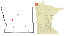 Location of Hallock within Kittson County and state of Minnesota | |
| Coordinates: 48°46′20″N 96°56′38″W / 48.77222°N 96.94389°W | |
| Country | United States |
| State | Minnesota |
| County | Kittson |
| Area | |
| • Total | 2.20 sq mi (5.69 km2) |
| • Land | 2.13 sq mi (5.52 km2) |
| • Water | 0.07 sq mi (0.17 km2) |
| Elevation | 817 ft (249 m) |
| Population | |
| • Total | 981 |
| • Estimate (2021)[3] | 933 |
| • Density | 432.19/sq mi (166.84/km2) |
| Time zone | UTC-6 (Central (CST)) |
| • Summer (DST) | UTC-5 (CDT) |
| ZIP codes | 56728, 56740, 56755 |
| Area code(s) | 218 |
| FIPS code | 27-26576 |
| GNIS feature ID | 0644582[4] |
| Website | hallockmn.org |

Hallock is a city in and the county seat of Kittson County, Minnesota, United States.[5] The population was 981 at the 2010 census.[6]
History[]
Hallock was platted in 1879.[7] The city was named for Charles Hallock, an American writer.[7] Hallock was incorporated as a city in 1887.[7] A post office has been in operation at Hallock since 1879.[8]
Geography[]
According to the United States Census Bureau, the city has a total area of 2.10 square miles (5.44 km2), of which 2.04 square miles (5.28 km2) is land and 0.06 square miles (0.16 km2) is water.[9]
U.S. Highway 75 and Minnesota State Highway 175 are two of the main routes in the city.

Climate[]
| Climate data for Hallock, Minnesota (1991–2020 normals, extremes 1899–present) | |||||||||||||
|---|---|---|---|---|---|---|---|---|---|---|---|---|---|
| Month | Jan | Feb | Mar | Apr | May | Jun | Jul | Aug | Sep | Oct | Nov | Dec | Year |
| Record high °F (°C) | 50 (10) |
61 (16) |
77 (25) |
98 (37) |
105 (41) |
103 (39) |
109 (43) |
103 (39) |
102 (39) |
92 (33) |
75 (24) |
54 (12) |
109 (43) |
| Average high °F (°C) | 13.1 (−10.5) |
17.7 (−7.9) |
31.6 (−0.2) |
50.1 (10.1) |
66.3 (19.1) |
75.8 (24.3) |
79.4 (26.3) |
78.6 (25.9) |
68.7 (20.4) |
51.7 (10.9) |
33.9 (1.1) |
19.0 (−7.2) |
48.8 (9.3) |
| Daily mean °F (°C) | 4.5 (−15.3) |
8.6 (−13.0) |
23.7 (−4.6) |
40.1 (4.5) |
54.5 (12.5) |
64.7 (18.2) |
68.4 (20.2) |
67.0 (19.4) |
57.2 (14.0) |
42.6 (5.9) |
26.2 (−3.2) |
11.8 (−11.2) |
39.1 (3.9) |
| Average low °F (°C) | −4.1 (−20.1) |
−0.4 (−18.0) |
15.8 (−9.0) |
30.0 (−1.1) |
42.7 (5.9) |
53.7 (12.1) |
57.4 (14.1) |
55.5 (13.1) |
45.8 (7.7) |
33.4 (0.8) |
18.5 (−7.5) |
4.6 (−15.2) |
29.4 (−1.4) |
| Record low °F (°C) | −48 (−44) |
−46 (−43) |
−42 (−41) |
−13 (−25) |
11 (−12) |
24 (−4) |
34 (1) |
28 (−2) |
13 (−11) |
−7 (−22) |
−32 (−36) |
−49 (−45) |
−49 (−45) |
| Average precipitation inches (mm) | 0.53 (13) |
0.47 (12) |
0.72 (18) |
1.14 (29) |
3.00 (76) |
4.24 (108) |
3.49 (89) |
2.58 (66) |
2.57 (65) |
1.85 (47) |
0.93 (24) |
0.79 (20) |
22.31 (567) |
| Source: NOAA[10][11] | |||||||||||||
Demographics[]
| Historical population | |||
|---|---|---|---|
| Census | Pop. | %± | |
| 1890 | 302 | — | |
| 1900 | 805 | 166.6% | |
| 1910 | 910 | 13.0% | |
| 1920 | 1,012 | 11.2% | |
| 1930 | 869 | −14.1% | |
| 1940 | 1,353 | 55.7% | |
| 1950 | 1,552 | 14.7% | |
| 1960 | 1,527 | −1.6% | |
| 1970 | 1,477 | −3.3% | |
| 1980 | 1,405 | −4.9% | |
| 1990 | 1,304 | −7.2% | |
| 2000 | 1,196 | −8.3% | |
| 2010 | 981 | −18.0% | |
| 2019 (est.) | 921 | [3] | −6.1% |
| U.S. Decennial Census[12] | |||
2010 census[]
At the 2010 census,[2] there were 981 people, 449 households and 256 families living in the city. The population density was 480.9 inhabitants per square mile (185.7/km2). There were 549 housing units at an average density of 269.1 per square mile (103.9/km2). The racial makeup of the city was 98.7% White, 0.1% African American, 0.6% Asian, 0.1% from other races, and 0.5% from two or more races. Hispanic or Latino of any race were 2.8% of the population.
There were 449 households, of which 19.2% had children under the age of 18 living with them, 49.9% were married couples living together, 4.9% had a female householder with no husband present, 2.2% had a male householder with no wife present, and 43.0% were non-families. 40.5% of all households were made up of individuals, and 23.4% had someone living alone who was 65 years of age or older. The average household size was 2.04 and the average family size was 2.77.
The median age in the city was 51.9 years. 17.7% of residents were under the age of 18; 4.1% were between the ages of 18 and 24; 17% were from 25 to 44; 31.5% were from 45 to 64; and 29.8% were 65 years of age or older. The gender makeup of the city was 47.2% male and 52.8% female.
2000 census[]
As of census of 2000, there were 1,196 people, 485 households and 305 families living in the city. The population density was 573.2 per square mile (220.9/km2). There were 586 housing units at an average density of 280.9 per square mile (108.3/km2). The racial makeup of the city was 97.91% White, 0.08% African American, 0.17% Native American, 0.17% Asian, 0.59% from other races, and 1.09% from two or more races. Hispanic or Latino of any race were 1.42% of the population.
There were 485 households, of which 30.1% had children under the age of 18 living with them, 54.0% were married couples living together, 6.8% had a female householder with no husband present, and 37.1% were non-families. 35.3% of all households were made up of individuals, and 21.2% had someone living alone who was 65 years of age or older. The average household size was 2.29 and the average family size was 3.00.
24.8% of the population were under the age of 18, 3.8% from 18 to 24, 23.3% from 25 to 44, 21.1% from 45 to 64, and 26.9% who were 65 years of age or older. The median age was 44 years. For every 100 females, there were 81.5 males. For every 100 females age 18 and over, there were 81.3 males.
The median household income was $37,063 and the median family income was $46,042. Males had a median income of $31,848 compared with $21,136 for females. The per capita income for the city was $18,156. About 3.3% of families and 4.8% of the population were below the poverty line, including 4.0% of those under age 18 and 7.8% of those age 65 or over.
Politics[]
| Year | Republican | Democratic | Third parties |
|---|---|---|---|
| 2020 | 49.0% 266 | 47.3% 257 | 3.7% 20 |
| 2016 | 51.3% 272 | 40.6% 215 | 8.1% 43 |
| 2012 | 47.7% 254 | 49.4% 263 | 2.9% 15 |
| 2008 | 37.3% 225 | 61.2% 369 | 1.5% 9 |
| 2004 | 46.7% 303 | 51.9% 337 | 1.4% 9 |
| 2000 | 47.8% 308 | 44.8% 289 | 7.4% 48 |
In popular culture[]
Hallock was a main filming location in the Coen brothers' 1996 film Fargo, substituting as a fictional version of Brainerd, Minnesota due to Hallock having a better snowfall than Brainerd during production.
Notable people[]
- Kristen Dexter, Wisconsin politician[19]
- Marv Hanson, Minnesota legislator
- Frederick McKinley Jones, inventor
- Donald Pederson, educator and inventor
- Bill Ingebrigtsen, State Senator
References[]
- ^ "2019 U.S. Gazetteer Files". United States Census Bureau. Retrieved July 26, 2020.
- ^ a b "U.S. Census website". United States Census Bureau. Retrieved November 13, 2012.
- ^ a b "Population and Housing Unit Estimates". United States Census Bureau. May 24, 2020. Retrieved May 27, 2020.
- ^ "US Board on Geographic Names". United States Geological Survey. October 25, 2007. Retrieved January 31, 2008.
- ^ "Find a County". National Association of Counties. Retrieved June 7, 2011.
- ^ "2010 Census Redistricting Data (Public Law 94-171) Summary File". American FactFinder. U.S. Census Bureau, 2010 Census. Retrieved April 23, 2011.[dead link]
- ^ a b c Upham, Warren (1920). Minnesota Geographic Names: Their Origin and Historic Significance. Minnesota Historical Society. p. 277.
- ^ "Kittson County". Jim Forte Postal History. Retrieved July 17, 2015.
- ^ "US Gazetteer files 2010". United States Census Bureau. Archived from the original on July 2, 2012. Retrieved November 13, 2012.
- ^ "NowData - NOAA Online Weather Data". National Oceanic and Atmospheric Administration. Retrieved September 24, 2021.
- ^ "Station: Hallock, MN". U.S. Climate Normals 2020: U.S. Monthly Climate Normals (1991-2020). National Oceanic and Atmospheric Administration. Retrieved September 24, 2021.
- ^ United States Census Bureau. "Census of Population and Housing". Retrieved September 11, 2013.
- ^ https://www.sos.state.mn.us/elections-voting/election-results/2020/2020-general-election-results/2020-precinct-results-spreadsheet/.
{{cite web}}: Missing or empty|title=(help) - ^ https://www.sos.state.mn.us/elections-voting/election-results/2016/2016-general-election-results/2016-precinct-results-spreadsheet/.
{{cite web}}: Missing or empty|title=(help) - ^ https://www.sos.state.mn.us/elections-voting/election-results/2012/2012-general-election-results/2012-precinct-results-spreadsheet/.
{{cite web}}: Missing or empty|title=(help) - ^ https://www.sos.state.mn.us/elections-voting/election-results/2008/2008-general-election-results/2008-precinct-results-spreadsheet/.
{{cite web}}: Missing or empty|title=(help) - ^ https://www.sos.state.mn.us/elections-voting/election-results/2004/2004-general-election-results/2004-precinct-results-spreadsheet/.
{{cite web}}: Missing or empty|title=(help) - ^ https://www.sos.state.mn.us/elections-voting/election-results/2000/2000-general-election-results/2000-precinct-results-spreadsheet/.
{{cite web}}: Missing or empty|title=(help) - ^ Wisconsin Blue Book 2009-2010, biographical sketch of Kristen Dexter, pg. 65
External links[]
Municipalities and communities of Kittson County, Minnesota, United States | ||
|---|---|---|
| Cities |  | |
| Townships | ||
| Unorganized territories | ||
| Unincorporated communities | ||
| Ghost town | ||
| ||
Saint Paul (capital) | |||||
| Topics |
| ||||
| Society | |||||
| Regions | |||||
| Largest cities pop. over 25,000 |
| ||||
| Counties |
| ||||
| Attractions |
| ||||

Coordinates: 48°46′28″N 96°56′47″W / 48.77444°N 96.94639°W
- Cities in Minnesota
- Cities in Kittson County, Minnesota
- County seats in Minnesota