Bohdaneč
- For the spa town in the Czech Republic see Lázně Bohdaneč.
Bohdaneč | |
|---|---|
municipality of the Czech Republic | |
 | |
 Flag  Coat of arms | |
 Bohdaneč | |
| Coordinates: 49°46′41″N 15°13′23″E / 49.778°N 15.223°ECoordinates: 49°46′41″N 15°13′23″E / 49.778°N 15.223°E[1] | |
| Country | Czech Republic |
| Subdivision | Kutná Hora District |
| Area | |
| • Total | 16.594009 km2 (6.406983 sq mi) |
| Population | |
| • Total | 431 |
| • Density | 26/km2 (67/sq mi) |
| Postal code | 285 25 |
| Website | www |

Bohdaneč (formerly also known as Zelená Bohdaneč) is a village in the Central Bohemian Region of the Czech Republic. It is in the district of Kutná Hora, between the towns of Ledeč nad Sázavou and Zruč nad Sázavou.
Bohdaneč is first mentioned in written documents from 1233. In 1514 it obtained town privileges (later lost). The number of inhabitants declined during the second half of the 20th century.
These smaller villages are officially parts of Bohdaneč:
- Prostřední Ves: first mentioned in 1381
- Šlechtín
- Řeplice: first mentioned in 1381, since 1960 part of Bohdaneč
- Kotoučov: first mentioned in 1525, since 1960 part of Bohdaneč
- Dvorecko: first mentioned in 1487 under name Víceměřič, since 1960 part of Bohdaneč
Gallery[]
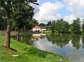
Pilský Pond
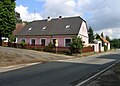
Old farm
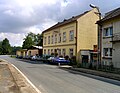
Municipal office

Grocery

Local marmor


References[]
- ^ Register of territorial identification, addresses and real estates, Wikidata Q12049125, retrieved 31 December 2014
- ^ Czech Statistical Office (30 April 2014), Počet obyvatel v obcích - k 1.1.2014 (in Czech), Prague, Wikidata Q56259648
- ^ Historický lexikon obcí České republiky – 1869–2011 (in Czech), Czech Statistical Office, 21 December 2015, Wikidata Q28708818
- ^ Czech Statistical Office (29 April 2016), Počet obyvatel v obcích - k 1.1.2016 (in Czech), Prague, Wikidata Q24560797, retrieved 3 September 2016
- ^ Czech Statistical Office (28 April 2017). Počet obyvatel v obcích - k 1.1.2017 (in Czech). Prague. ISBN 978-80-250-2770-7. Wikidata Q29678797. Retrieved 4 May 2017.
- ^ Czech Statistical Office (30 April 2018). Počet obyvatel v obcích - k 1.1.2018 (in Czech). Prague: Czech Statistical Office. ISBN 978-80-250-2843-8. Wikidata Q52417047. Retrieved 1 May 2018.
- ^ Czech Statistical Office (30 April 2019). Počet obyvatel v obcích - k 1.1.2019 (in Czech). Prague: Czech Statistical Office. ISBN 978-80-250-2914-5. Wikidata Q63450605. Retrieved 4 May 2019.
- ^ Czech Statistical Office (30 April 2020), Počet obyvatel v obcích - k 1.1.2020 (in Czech), Prague: Czech Statistical Office, Wikidata Q92748479, retrieved 1 May 2020
External links[]
| Wikimedia Commons has media related to Bohdaneč. |
- Village website (in Czech)
Coordinates: 49°46′33″N 15°13′23″E / 49.77583°N 15.22306°E
| Authority control: National libraries |
|---|
Categories:
- Populated places in Kutná Hora District
- Villages in Kutná Hora District
- Kutná Hora geography stubs