Bonita Beach Causeway
Bonita Beach Causeway | |
|---|---|
 Big Carlos Pass Bridge | |
| Coordinates | 26°24′16″N 81°52′51″W / 26.404328°N 81.880936°W |
| Carries | |
| Crosses | Big Carlos Pass Little Carlos Pass New Pass Big Hickory Pass |
| Locale | Bonita Springs, Florida |
| Maintained by | Lee County Department of Transportation |
| Characteristics | |
| Design | 1 steel bascule bridge & 3 concrete girder bridges |
| Total length | 4 Miles |
| History | |
| Opened | July 4, 1965 |
| Statistics | |
| Toll | None |
| Location | |
 | |

The Bonita Beach Causeway is a series of four low-level bridges located in Southwest Florida traversing the barrier islands of Estero Bay connecting the town of Fort Myers Beach with Bonita Springs. It carries Estero Boulevard (County Road 865) and is four miles (6.4 km) long from end to end. Each bridge on the Bonita Beach Causeway is named after the body of water it crosses.
Route description[]
Estero Boulevard (which crosses the causeway) begins just south of the Bonita Beach Causeway on Little Hickory Island, splitting off from Hickory Boulevard (County Road 865). It heads north and crosses Big Hickory Pass Bridge, which lands on Big Hickory Island. After a short distance, it then crosses the New Pass Bridge, and lands on Long Key, and enters the Lovers Key / Carl E. Johnson State Park. After crossing the Little Carlos Pass Bridge onto Black Key, Estero Boulevard turns west and crosses the Big Carlos Pass Bridge, a small single-leaf drawbridge, onto Estero Island, and the town of Fort Myers Beach.
History[]
Before the causeway's construction, the only way to access Estero Island and Fort Myers Beach by car was via the Matanzas Pass Bridge (which was still a small swing bridge at this time). The swing bridge's machinery was highly unreliable, which concerned islanders who feared the bridge would break down in the event of an emergency, such as a hurricane evacuation. The islanders felt having a second exit for the island for safety reasons would be wise.
The county then decided the most feasible location was to run the causeway from the south end of the island over barrier islands to Bonita Springs. The causeway's exact routing was selected by surveyor Carl Johnson (for whom Lovers Key / Carl E. Johnson State Park was named), and he became known as the father of the project. Construction began in 1963, and the causeway opened on July 4, 1965.[1]
Gallery[]
Big Hickory Pass Bridge
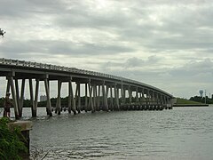
New Pass Bridge

The entrance to the Lovers Key / Carl E. Johnson State Park

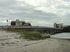
The Water Tower which welcomes southbound travelers on the Bonita Beach Causeway into Bonita Springs. It is on Big Hickory Island.


References[]
- ^ "A Short History of Fort Myers Beach". Town of Fort Myers Beach. Retrieved 2012-11-23.
Coordinates: 26°24′15.58″N 81°52′51.37″W / 26.4043278°N 81.8809361°W
- Bridges in Lee County, Florida
- Causeways in Florida
- Bonita Springs, Florida
- Road bridges in Florida
- Roads in Lee County, Florida
- Bridges completed in 1965
- Bridges completed in 1979
- 1965 establishments in Florida
- Steel bridges in the United States
- Concrete bridges in the United States
- Girder bridges in the United States
- Bascule bridges in the United States
- Transportation buildings and structures in Lee County, Florida