Bridgetown, Western Australia
| Bridgetown Western Australia | |
|---|---|
 Hampton Street, the main street of Bridgetown | |
 Bridgetown | |
| Coordinates | 33°57′30″S 116°08′17″E / 33.95833°S 116.13806°ECoordinates: 33°57′30″S 116°08′17″E / 33.95833°S 116.13806°E |
| Population | 2,812 (2016 census)[1] |
| Established | 1868 |
| Postcode(s) | 6255 |
| Elevation | 156.6 m (514 ft)[2] |
| Location |
|
| LGA(s) | Shire of Bridgetown-Greenbushes |
| State electorate(s) | Blackwood-Stirling |
| Federal Division(s) | O'Connor |

Bridgetown is a town in the South West region of Western Australia, approximately 270 kilometres (168 mi) south of Perth on the Blackwood River at the intersection of South Western Highway with Brockman Highway to Nannup and Augusta.
History[]
The area was originally known as Geegelup, which was believed to mean "place of gilgies" in the Noongar language, referring to the fresh water lobster that inhabits the area. However recent research suggests the actual meaning of Geegelup may be "place of spears".
In 1852, A.C. Gregory made the original survey of the Geegelup area and in 1857, Edward Godfrey Hester (now honoured in nearby Hester) and John Blechynden settled there. In 1861, convicts built the road from Donnybrook into the area.[3] In 1864 the Geegelup Post Office was established in a building on Blechynden’s property.[4] A basic police station that had existed since c1862 was substantially reconstructed by former convict, Joseph Smith on the south bank of the Blackwood River in mid 1867. Mounted Constable Abraham W. Moulton was the first permanently appointed policeman.[5]
The townsite was surveyed in April 1868 by Thomas Carey, who proposed the name Bridgetown for two reasons - "as it is at a bridge and the Bridgetown was the first ship to put in at Bunbury for the wool from these districts", and was approved and gazetted on 9 June 1868.[6][4]
From then until about 1885, many buildings including the primary school (1870), post office, new police station (1880) and two hotels were constructed, many of which are still standing today. In 1885, the Bridgetown Agricultural Society was formed and local farmers produced sheep, cattle, dairy products, timber, fruit and nuts. The building boom in Western Australia during the gold boom of the 1890s saw an increased demand for sawn timber, and numerous mills opened in the Bridgetown area.[4] The coming of the railway in 1898 enabled quick access to markets for the many orchardists and helped establish the beginning of a tourist industry.[7]
Until the 1980s, the land surrounding Bridgetown was almost exclusively used for broadacre agriculture and improved pasture. From the late 1970s, the area became increasingly attractive to tourists as a tranquil and picturesque country town an accessible distance from Perth. Some people, attracted by the area's aesthetic qualities and rural lifestyle moved to the town permanently, which resulted in a strong demand for residential and hobby farm allotments, at a time when there was a coincident global downturn in agricultural markets. Many farmers sold up, and much of the most aesthetically pleasing land was subdivided and sold. The demographic change had a profound impact on the town's industry, replacing demand for farm services with demand for services in the tourism and recreation sectors. However, the dramatic increase in infrastructure such as housing, roads and power reticulation detracted from the rural aesthetic that attracted the influx in the first place.[8]
Present day[]
Bridgetown is the seat of the Shire of Bridgetown-Greenbushes and the centre of a productive agricultural district. Many buildings in the town centre are over a century old. The town has a Jigsaw Gallery and Museum, which claims to host the only jigsaw collection of its kind in the Southern Hemisphere, and also a primary school (1870) and high school (1962), district hospital, telecentre, shire offices, roadhouse, agricultural showground, shopping facilities, accommodation for travellers (hotel/motel, B&Bs, caravan park) and numerous picnic spots along the Blackwood River. The rural residential area of Kangaroo Gully to the town's east has grown since the 1990s. Each year, Bridgetown hosts many events,[9] including:
- May: Festival of Country Gardens[10] (autumn)
- June to August: Bridgetown in the Winter Festival. Shops are adorned with blue lights, many events and workshops.
- October: Blackwood Marathon[11]
- October: Blackwood Valley Wine Show[12]
- November: Bridgetown Garden Festival[13]
- November: Blues at Bridgetown music festival[14]
- November: Agricultural show (which traces its roots to the 1920s)
- November: Festival of Country Gardens (spring)[10]
Geography[]
Climate[]
Bridgetown experiences a cool Mediterranean climate (Köppen climate classification Csb).
| hideClimate data for Bridgetown (averages: 1998–2018; extremes: 1907–2018) | |||||||||||||
|---|---|---|---|---|---|---|---|---|---|---|---|---|---|
| Month | Jan | Feb | Mar | Apr | May | Jun | Jul | Aug | Sep | Oct | Nov | Dec | Year |
| Record high °C (°F) | 43.5 (110.3) |
46.1 (115.0) |
41.5 (106.7) |
36.9 (98.4) |
31.6 (88.9) |
24.6 (76.3) |
24.3 (75.7) |
26.6 (79.9) |
29.8 (85.6) |
35.8 (96.4) |
39.4 (102.9) |
41.5 (106.7) |
46.1 (115.0) |
| Average high °C (°F) | 30.0 (86.0) |
29.8 (85.6) |
27.4 (81.3) |
23.4 (74.1) |
19.6 (67.3) |
16.7 (62.1) |
15.7 (60.3) |
16.4 (61.5) |
17.6 (63.7) |
20.5 (68.9) |
24.4 (75.9) |
27.4 (81.3) |
22.4 (72.3) |
| Average low °C (°F) | 13.2 (55.8) |
13.5 (56.3) |
11.9 (53.4) |
9.3 (48.7) |
6.8 (44.2) |
5.1 (41.2) |
4.5 (40.1) |
5.1 (41.2) |
6.0 (42.8) |
7.2 (45.0) |
9.4 (48.9) |
11.0 (51.8) |
8.6 (47.5) |
| Record low °C (°F) | 0.9 (33.6) |
0.5 (32.9) |
−0.9 (30.4) |
−2.2 (28.0) |
−2.5 (27.5) |
−5.7 (21.7) |
−4.4 (24.1) |
−3.9 (25.0) |
−2.8 (27.0) |
−2.2 (28.0) |
−0.9 (30.4) |
0.0 (32.0) |
−5.7 (21.7) |
| Average precipitation mm (inches) | 17.2 (0.68) |
12.3 (0.48) |
20.4 (0.80) |
48.7 (1.92) |
99.3 (3.91) |
114.7 (4.52) |
130.3 (5.13) |
122.5 (4.82) |
88.1 (3.47) |
42.7 (1.68) |
30.1 (1.19) |
19.7 (0.78) |
721.4 (28.40) |
| Average rainy days | 3.9 | 3.6 | 5.8 | 11.4 | 18.2 | 21.3 | 24.3 | 23.4 | 19.1 | 12.6 | 7.4 | 5.0 | 156.0 |
| Source: Bureau of Meteorology[15][16] | |||||||||||||
Notable people[]
- Emily Barker, singer-songwriter
- Jon Doust, author and comedian
- Robyn McSweeney, politician
- Tom O'Dwyer, cricketer
- David Reid, politician
- Deborah Robertson, novelist and poet
- Fred Riebeling, politician
- Len Pascoe, cricketer
- Bruce Maslin, botanist
Gallery[]
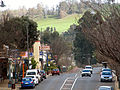
Main street, Bridgetown, August 2007
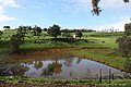
A typical rural landscape in the vicinity of Bridgetown


References[]
- ^ Australian Bureau of Statistics (27 June 2017). "Bridgetown (State suburb)". 2016 Census QuickStats. Retrieved 29 May 2019.

- ^ "Bridgetown WA 6255 Elevation". Distancesto. Retrieved 26 March 2021.
- ^ Shire of Bridgetown-Greenbushes. "Tourism - Heritage". Archived from the original on 5 October 2006. Retrieved 3 November 2006.
- ^ Jump up to: a b c "Register of Heritage Places - Assessment Documentation: Bridgetown Post Office". Perth, WA: Heritage Council of Western Australia. 2 September 1997. Retrieved 29 May 2019.
- ^ Bridgetown Historical Society
- ^ Western Australian Land Information Authority. "History of country town names – B". Retrieved 17 January 2007.
- ^ Bridgetown Historical Society
- ^ Tonts, Matthew; Greive, Shane (2002). "Commodification and creative destruction in the Australian rural landscape: the case of Bridgetown, Western Australia". Australian Geographical Studies. 40 (1): 58–70. doi:10.1111/1467-8470.00161.
- ^ http://www.bridgetown.com.au/events.asp
- ^ Jump up to: a b https://web.archive.org/web/20070409080846/http://www.countrygardens.com.au/
- ^ http://www.mccays.com.au/theevent
- ^ http://www.blackwoodvalleywine.asn.au/
- ^ https://web.archive.org/web/20140125073015/http://bridgetowngardenfestival.com.au/
- ^ http://www.bluesatbridgetown.com
- ^ "Climate statistics for Bridgtown". Bureau of Meteorology. Retrieved 5 December 2018.
- ^ "Climate statistics for Bridgtown Comparison". Bureau of Meteorology. Retrieved 5 December 2018.
- Bridgetown Historical Society
- Shire of Bridgetown-Greenbushes
- Bridgetown-Greenbushes Visitor Centre
- Blues at Bridgetown
- Blackwood Marathon
- Festival of Country Gardens
- Blackwood River Valley
- Bridgetown's climate statistics
- Bridgetown's daily weather statistics
- https://web.archive.org/web/20080718194116/http://www.btownfilms.com/ Bridgetown Film Festival January
| show Authority control |
|---|
- Towns in Western Australia
- Bridgetown, Western Australia
- Blackwood River