Brownsburg-Chatham, Quebec
Brownsburg-Chatham | |
|---|---|
City | |
 | |
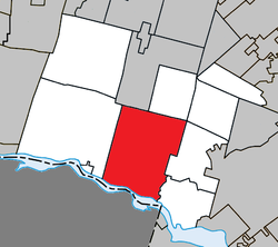 Location within Argenteuil RCM. | |
 Brownsburg-Chatham Location in central Quebec. | |
| Coordinates: 45°41′N 74°25′W / 45.683°N 74.417°WCoordinates: 45°41′N 74°25′W / 45.683°N 74.417°W[1] | |
| Country | |
| Province | |
| Region | Laurentides |
| RCM | Argenteuil |
| Settled | Early 1800s |
| Constituted | October 6, 1999 |
| Government | |
| • Mayor | Catherine Trickey |
| • Federal riding | Argenteuil—La Petite-Nation |
| • Prov. riding | Argenteuil |
| Area | |
| • Total | 255.20 km2 (98.53 sq mi) |
| • Land | 248.38 km2 (95.90 sq mi) |
| Population (2011)[3] | |
| • Total | 7,209 |
| • Density | 29.0/km2 (75/sq mi) |
| • Pop 2006-2011 | |
| • Dwellings | 3,651 |
| Time zone | UTC−5 (EST) |
| • Summer (DST) | UTC−4 (EDT) |
| Postal code(s) | J8G |
| Area code(s) | 450 and 579 |
| Highways | |
| Website | www.brownsburg chatham.ca |


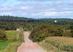
Brownsburg-Chatham is a municipality in the Laurentides region of Quebec, Canada, part of the Argenteuil Regional County Municipality. It is located along the Ottawa River, just west of Lachute, and includes the communities of Brownsburg, Cushing, Dalesville, Greece's Point, Pine Hill, and Saint-Philippe. Economic activities include agriculture, tourism and the manufacture of explosives.
It is the hometown of late Montreal Canadiens defenceman Gilles Lupien.
History[]
Chatham Township was established in 1799, and named after English Statesman William Pitt, 1st Earl of Chatham (1708–1778). Mostly populated by rich American Loyalists, its post office opened in 1829 and the township municipality was formed in 1845. By the mid-19th century, there were a few hamlets including Dalesville, Brownsbury, and Starneville.[1]
In 1818, Major George Brown, born in England, was granted by the government land on the West River (Rivière de l'Ouest). Together with pioneers Daniel Smith and Captain A. L. Howard, he was able to breathe life into the local industry during the 1820s. George Brown built, among other achievements, a sawmill and gristmill which contributed to the economic growth of the region and led to the formation of Brownsburg village which was named after him. In 1854, the Brownsburg Post Office opened. Later in the third quarter of the 19th century, a major arms factory run by the Dominion Cartridge Company was the major local industry.[1]
In 1935, the Village Municipality of Brownsburg was officially established by separating from the Township Municipality of Chatham.[1]
On October 6, 1999, Brownsburg was rejoined with Chatham and the new Municipality of Brownsburg-Chatham was formed. On July 6, 2002, the municipality changed its statutes and became the Town of Brownsburg-Chatham.[1]
Demographics[]
Population[]
| hideCanada census – Brownsburg-Chatham, Quebec community profile | |||
|---|---|---|---|
| 2011 | 2006 | ||
| Population: | 7209 (+8.2% from 2006) | 6,664 (-1.6% from 2001) | |
| Land area: | 248.38 km2 (95.90 sq mi) | 247.02 km2 (95.37 sq mi) | |
| Population density: | 29.0/km2 (75/sq mi) | 27.0/km2 (70/sq mi) | |
| Median age: | 44.1 (M: 44.3, F: 43.9) | 42.7 (M: 42.8, F: 42.7) | |
| Total private dwellings: | 3,651 | 3,375 | |
| Median household income: | $44,790 | $44,452 | |
| References: 2011[4] 2006[5] earlier[6] | |||
|
|
| ||||||||||||||||||||||||
(P) pre-merger total for Brownsburg and Chatham | ||||||||||||||||||||||||||
Language[]
| Canada Census Mother Tongue - Brownsburg-Chatham, Quebec[7] | ||||||||||||||||||
|---|---|---|---|---|---|---|---|---|---|---|---|---|---|---|---|---|---|---|
| Census | Total | French
|
English
|
French & English
|
Other
| |||||||||||||
| Year | Responses | Count | Trend | Pop % | Count | Trend | Pop % | Count | Trend | Pop % | Count | Trend | Pop % | |||||
2011
|
7,130
|
5,735 | 80.43% | 1,145 | 16.06% | 105 | 1.47% | 145 | 2.03% | |||||||||
2006
|
6,620
|
5,280 | 79.76% | 1,055 | 15.94% | 55 | 0.83% | 230 | 3.47% | |||||||||
2001
|
6,655
|
5,320 | 79.94% | 1,105 | 16.60% | 135 | 2.03% | 95 | 1.43% | |||||||||
1996
|
6,605
|
5,230 | n/a | 79.18% | 1,185 | n/a | 17.94% | 95 | n/a | 1.44% | 95 | n/a | 1.44% | |||||
Education[]
The Commission scolaire de la Rivière-du-Nord operates French-language public schools.
- École primaire Bouchard and Le Centre de Tremplin
- in Lachute[8]
The Sir Wilfrid Laurier School Board operates English-language public schools:
- Laurentian Elementary School in Lachute serves almost all areas[9]
- Grenville Elementary School in Grenville serves a small section of Chatham[10]
- Laurentian Regional High School in Lachute serves all areas[11]
Politics[]
The city council meetings are available online since February 2, 2016.
See also[]
- List of cities in Quebec
References[]
- ^ Jump up to: a b c d e "Brownsburg-Chatham (Ville)" (in French). Commission de toponymie du Québec. Retrieved 2010-06-09.
- ^ Jump up to: a b Geographic code 76043 in the official Répertoire des municipalités (in French)
- ^ Jump up to: a b "(Code 2476043) Census Profile". 2011 census. Statistics Canada. 2012.
- ^ "2011 Community Profiles". 2011 Canadian Census. Statistics Canada. July 5, 2013. Retrieved 2014-03-03.
- ^ "2006 Community Profiles". 2006 Canadian Census. Statistics Canada. March 30, 2011. Retrieved 2014-03-03.
- ^ "2001 Community Profiles". 2001 Canadian Census. Statistics Canada. February 17, 2012.
- ^ Jump up to: a b Statistics Canada: 1996, 2001, 2006, 2011 census
- ^ "Trouver une école ou un centre." Commission scolaire de la Rivière-du-Nord. Retrieved on September 24, 2017. For attendance boundary information, click "Par bassin d'école"
- ^ "LAURENTIAN ELEMENTARY ZONE." Sir Wilfrid Laurier School Board. Retrieved on September 16, 2017.
- ^ "About Us." Grenville Elementary School. Retrieved on September 17, 2017.
- ^ "LAURENTIAN REGIONAL HS ZONE." Sir Wilfrid Laurier School Board. Retrieved on September 4, 2017.
External links[]
| show Adjacent Municipal Subdivisions |
|---|
| hide | |
|---|---|
| Towns | |
| Municipalities | |
| Townships | |
| Villages | |
| |
| Authority control |
|
|---|
- Cities and towns in Quebec
- Incorporated places in Laurentides
- Populated places established in 1799