Bumble Bee, Arizona
Bumble Bee, Arizona | |
|---|---|
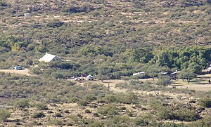 Bumble Bee townsite, 2017. Bumble Bee Creek is above the house. | |
 Bumble Bee, Arizona Location within the state of Arizona | |
| Coordinates: 34°12′03″N 112°09′11″W / 34.20083°N 112.15306°WCoordinates: 34°12′03″N 112°09′11″W / 34.20083°N 112.15306°W[1] | |
| Country | United States |
| State | Arizona |
| County | Yavapai |
| Elevation | 2,579 ft (786 m) |
| Time zone | UTC-7 (Mountain (MST)) |


Bumble Bee is a ghost town in the Bradshaw Mountains of Yavapai County, Arizona, United States,[1] named for nearby Bumble Bee Creek. The townsite area is commonly used by RV campers in winter.
Development[]

Established in 1863, Bumble Bee served as a stagecoach stop and an outpost for the U.S. Cavalry, with a post office established in 1879. The creek, and by extension the town, were so named because early travelers in the area claimed that the indigenous people there were as "thick as bumblebees".[2][3]
Ghost town status[]
With the demise of the stagecoach and the mining in the surrounding area, the site eventually faded away. An attempt by Jeff Martin to make the town a tourist attraction during the mid-1930s resulted in the construction of the current buildings. In 1960, retired magazine publisher Charles A. Penn purchased the site and tried once again to establish a tourist attraction and museum. Penn died before his plans came to fruition and the property reverted to private ownership. Many of the faux historic buildings have since been torn down and smaller homes have been built in their place.
Bumble Bee is located 55 miles north of Phoenix, just off I-17 at Exit #248.[2]
References[]
- ^ a b c d U.S. Geological Survey Geographic Names Information System: Bumble Bee, Arizona
- ^ a b "Bumble Bee Just Never Made It". Retrieved 12 April 2011.
- ^ Moyer, Armond; Moyer, Winifred (1958). The origins of unusual place-names. Keystone Pub. Associates. p. 18.
External links[]

- Former populated places in Yavapai County, Arizona
- Ghost towns in Arizona