Prescott, Arizona
Prescott | |
|---|---|
City | |
 Courthouse and Buckey O'Neill statue | |
 Seal Wordmark | |
| Motto(s): "Welcome to Everybody's Hometown" | |
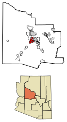 Location of Prescott in Yavapai County, Arizona. | |
 Prescott Location in Arizona | |
| Coordinates: 34°32′24″N 112°28′07″W / 34.54000°N 112.46861°WCoordinates: 34°32′24″N 112°28′07″W / 34.54000°N 112.46861°W[1] | |
| Country | United States |
| State | Arizona |
| County | Yavapai |
| Incorporated | 1881[2] |
| Government | |
| • Type | Council-Manager |
| • Mayor | Greg Mengarelli |
| Area | |
| • City | 45.17 sq mi (116.99 km2) |
| • Land | 44.93 sq mi (116.37 km2) |
| • Water | 0.24 sq mi (0.62 km2) |
| Elevation | 5,367 ft (1,636 m) |
| Population | |
| • City | 39,843 |
| • Estimate (2019)[5] | 44,299 |
| • Density | 985.91/sq mi (380.66/km2) |
| • Metro | 129,643 (Landscan) |
| Time zone | UTC−7 (MST (no DST)) |
| ZIP codes | 86300-86399 |
| Area code(s) | 928 |
| FIPS code | 04-57380 |
| GNIS feature ID | 33189 [1] |
| Website | www |


Prescott (/ˈprɛskət/ PRESS-kət)[6][7][8] is a city in Yavapai County, Arizona, United States. According to the 2010 Census, the city's population was 39,843. The city is the county seat of Yavapai County.[9] In 1864, Prescott was designated as the capital of the Arizona Territory, replacing the temporary capital of Fort Whipple.[10] The Territorial Capital was moved to Tucson in 1867. Prescott again became the Territorial Capital in 1877, until Phoenix became the capital in 1889.
The towns of Prescott Valley, 7 miles (11 km) east; Chino Valley, 16 miles (26 km) north; Dewey-Humboldt, 13 miles (21 km) east, and Prescott comprise what is locally known as the "Quad-City" area.[11] This also sometimes refers to central Yavapai County in general, which would include the towns of: Mayer, Paulden, Wilhoit, and Williamson Valley. Combined with these smaller communities the area had a population of 103,260 as of 2007. Prescott is the center of the Prescott Metropolitan Area, defined by the U.S. Census Bureau as all of Yavapai County.
The Yavapai-Prescott Indian Tribe reservation is adjacent to and partially within the borders of Prescott.
Prescott is in the Granite Creek watershed and contains the convergence of Miller Creek and Granite Creek on its north side.[12]
History[]

Arizona Territorial Governor John Noble Goodwin selected the original site of Prescott following his first tour of the new territory. Goodwin replaced Governor John A. Gurley, appointed by Abraham Lincoln, who died before taking office. Downtown streets in Prescott are named in honor of both of them. Goodwin selected a site 20 miles (32 km) south of the temporary capital on the east side of Granite Creek near a number of mining camps.
The territorial capital was later moved to the new site along with Fort Whipple, with the new town named in honor of historian William H. Prescott during a public meeting on May 30, 1864.[10] Robert W. Groom surveyed the new community, and an initial auction sold 73 lots on June 4, 1864. By July 4, 1864, 232 lots had been sold within the new community.[13] Prescott was incorporated in 1881.[2]
Prescott served as capital of Arizona Territory until November 1, 1867, when the capital was moved to Tucson by act of the 4th Arizona Territorial Legislature.[14] The capital was returned to Prescott in 1877 by the 9th Arizona Territorial Legislature.[15] The capital was finally moved to Phoenix on February 4, 1889, by the 15th Arizona Territorial Legislature.[16] The three Arizona Territory capitals reflected the changes in political influence of different regions of the territory as they grew and developed.
Prescott also holds a place in the larger history of the American southwest. Both Virgil Earp (brother of Wyatt Earp) and Doc Holliday lived in Prescott before their now infamous gunfight at the O.K. Corral. Virgil Earp lived in Prescott starting in 1878 as a constable/watchman.[17] Doc Holliday was there for a while in the summer of 1880 and even appears in the 1880 census records.[18][19]
The Sharlot Hall Museum houses much of Prescott's territorial history, and the Museum of Indigenous People (formerly the Smoki museum)[20] and Phippen museums also maintain local collections. Whiskey Row in downtown Prescott boasts many historic buildings, including The Palace, Arizona's oldest restaurant and bar is still the oldest frontier saloon in Arizona. Many other buildings that have been converted to boutiques, art galleries, bookstores, and restaurants. Prescott is home to the Arizona Pioneers' Home. The Home opened during territorial days, February 1, 1911.
After several major fires in the early part of the century, downtown Prescott was rebuilt with brick. The central courthouse plaza, a lawn under huge old elm trees, is a gathering and meeting place. Cultural events and performances take place on many nights in the summer on the plaza.
Barry Goldwater, the 1964 Republican nominee for president, launched his presidential campaign from the steps of Prescott's Yavapai County Courthouse.
Nineteen members of the Granite Mountain Hotshots, part of the Prescott Fire Department, lost their lives Sunday, June 30, 2013, while battling the Yarnell Hill fire that had ignited two days earlier south of Prescott.
Geography[]

Prescott is 55 mi (89 km) west-northwest of the State of Arizona's geographic center.
According to the United States Census Bureau, the city has a total area of 41.5 sq mi (107.5 km2), of which 40.7 sq mi (105.4 km2) is land and 0.81 sq mi (2.1 km2) is water.
Prescott is considered part of North Central Arizona. It is just south of the Granite Dells. The Granite Dells area, or often called ‘The Dells’, is known for its large boulder outcroppings of granite that have eroded into a spectacular appearance of bumpy rock features. Within 'The Dells[21]' are Watson and Willow Lakes, which are two small, man-made reservoirs. Here a number of hiking trails connect to the Peavine Trail.[22] The Peavine National Recreation Trail follows what was the former rail bed of the Santa Fe. This railroad traveled from Prescott to Phoenix through the Granite Dells. The "Peavine" got its name from the winding portion of this railroad that twists and curves, resembling the vine on which peas grow. The Peavine trail connects to the Iron King Trail, which was the route of the old Prescott Railroad through the Granite Dells. Other lakes include Lynx, Granite Basin and Goldwater, all surrounding different areas of this rustic community. Goldwater Lake,[23] by Goldwater Park, is 4 miles (6.4 km) from downtown Prescott, has 15 acres (6.1 ha) of water surface, and is a popular destination for park recreation and picnic facilities. Lynx Lake[24] is another lake close to Prescott in tall ponderosa pines, and gets some 125,000 visitors every year. This 55-acre (22 ha) lake offers visitors recreational activities, boating, camping, fishing, hiking, mountain biking, picnicking and a small, seasonal restaurant with a view of the lake. Finally, there is the smallest of the natural lakes with 5 acres (2.0 ha) of surface water at Granite Basin Lake.[25] None of these lakes permits swimming due to a history of water quality problems,[26][27] however all are popular recreational destinations near Prescott.
Granite Creek flows generally north from the Bradshaw Mountains through the city, the Granite Dells, and the Little Chino Valley to the Verde River.
Climate[]
Prescott is in the Bradshaw Mountains of central Arizona, at an elevation of 5,400 feet (1,600 m). The city has a Mediterranean climate (Köppen Csa); however, unlike most other locations in this climate class, there is a pronounced summer wet season due to the North American Monsoon.
Average annual precipitation for 1991-2020 was 16.46 inches (418 mm), with spring and early summer the driest times of the year.[28][29] Snowfall is typically light and snow cover usually melts away quickly; the average seasonal total was 10.2 inches (26 cm).The largest portion of precipitation falls during the July–September monsoon season. Average daytime temperatures remain above 50 °F (10 °C) the entire year, but diurnal temperature variation is large throughout the year, averaging nearly 30 °F (17 °C) annually.[28][29] On average, temperatures reach 90 °F (32 °C) on 44 days annually, though 100 °F (38 °C)+ readings are uncommon and occur only 1-2 days per year on average, much unlike the Sonoran Desert to the south and Mojave Desert to the west. The average season for freezing temperatures is October 21 through May 1.[citation needed]
There was a severe drought from 1999 to 2009, seen from the lack of snowpack in the Bradshaw Mountains. Local creeks do not contain water except immediately after the rare rains. Nevertheless, at the start of 2007 lakes were reported as full. The winter of 2005–06 had less than 3 inches (7.6 cm) of snow, compared to an average snowfall of 12.8 inches (33 cm).[30]
| hideClimate data for Prescott, Arizona (1991-2020 normals, extremes 1898-) | |||||||||||||
|---|---|---|---|---|---|---|---|---|---|---|---|---|---|
| Month | Jan | Feb | Mar | Apr | May | Jun | Jul | Aug | Sep | Oct | Nov | Dec | Year |
| Record high °F (°C) | 73 (23) |
77 (25) |
83 (28) |
89 (32) |
97 (36) |
105 (41) |
105 (41) |
103 (39) |
98 (37) |
92 (33) |
83 (28) |
78 (26) |
105 (41) |
| Average high °F (°C) | 52.6 (11.4) |
55.2 (12.9) |
61.2 (16.2) |
67.8 (19.9) |
76.3 (24.6) |
87.0 (30.6) |
89.6 (32.0) |
87.2 (30.7) |
82.4 (28.0) |
72.9 (22.7) |
61.6 (16.4) |
51.9 (11.1) |
70.5 (21.4) |
| Average low °F (°C) | 23.8 (−4.6) |
26.4 (−3.1) |
31.6 (−0.2) |
37.3 (2.9) |
45.0 (7.2) |
53.6 (12.0) |
61.0 (16.1) |
59.7 (15.4) |
52.2 (11.2) |
40.1 (4.5) |
29.8 (−1.2) |
23.6 (−4.7) |
40.3 (4.6) |
| Record low °F (°C) | −21 (−29) |
−12 (−24) |
2 (−17) |
11 (−12) |
20 (−7) |
28 (−2) |
34 (1) |
32 (0) |
26 (−3) |
13 (−11) |
−1 (−18) |
−9 (−23) |
−21 (−29) |
| Average precipitation inches (mm) | 1.52 (39) |
1.78 (45) |
1.46 (37) |
0.57 (14) |
0.51 (13) |
0.23 (5.8) |
2.69 (68) |
2.78 (71) |
1.64 (42) |
0.96 (24) |
0.87 (22) |
1.45 (37) |
16.46 (417.8) |
| Average snowfall inches (cm) | 1.9 (4.8) |
3.1 (7.9) |
2.5 (6.4) |
0.4 (1.0) |
0 (0) |
0 (0) |
0 (0) |
0 (0) |
0 (0) |
0 (0) |
0.9 (2.3) |
1.4 (3.6) |
10.2 (26) |
| Average precipitation days (≥ 0.01 in) | 5.6 | 5.9 | 5.4 | 3.2 | 3.0 | 1.6 | 9.9 | 9.9 | 5.9 | 3.9 | 3.8 | 5.1 | 63.2 |
| Average snowy days (≥ 0.1 in) | 1.2 | 1.2 | 0.8 | 0.3 | 0 | 0 | 0 | 0 | 0 | 0 | 0.4 | 1.3 | 5.2 |
| Source: NOAA[31][32] | |||||||||||||
Monsoon season[]
Prescott is affected each year by the North American Monsoon.[33] Monsoon season is June 15–Sept. 15, and brings significant rain, wind, hail, thunderstorms, and flooding to the area. In spite of the dangers of flash floods and wildfires, many locals enjoy monsoon season for the relief of cooler temperatures, which commonly result from storms during the height of summer heatwaves.[34]
Arizona receives half of its annual rainfall during monsoon season, but this can be misleading. Monthly averages in precipitation can give the false impression that rains are confined to monsoon season, while single-day annual rainfall records have been set far outside of monsoon season, repeatedly.[35] The area is prone to weather extremes and often, monthly rainfall records are actually the result of one or two dramatic rain events.[citation needed]
Flood risk[]
Prescott area residents have faced the challenges of extreme rain and flash flooding since the first prospectors arrived in search of gold in the late 1800s. In 1863 Joseph R. Walker's original mining camp on the banks of Lynx Creek was completely swept away in a flash flood less than a year after arriving in Prescott.[36][37] In the late 1880s, floods destroyed the first dam on Lynx creek near present-day SR-69.[38] 1891 brought the heaviest flooding on record across Arizona (a record broken in 1993), carving lasting changes to the Verde river drainage, bordering Prescott. The Verde, which has in some years been completely dry, gushed with 4,284 cubic meters per second of water on Feb 24, 1891, or about half the size of the Columbia river.[39][40]
Tropical Storm Octave, in 1983, brought 14.5" of rain to parts of Prescott in less than forty-eight hours. Damages included the Santa Fe Railway, which was washed out in so many places it was completely abandoned the following year.[41][42] Two Prescott area college students died in Granite Creek during flooding in 2004, which brought an official state of emergency declaration from state governor Napolitano.[43] Significant flooding has been recorded as recently as 2018, prompting the evacuation of nearby Mayer in August.[44]
A large number of homes in Prescott are located within FEMA designated "high risk flood zones A and AE".[45] The City of Prescott recently updated Flood Insurance Rate Maps in response to increased construction and notable flooding for several consecutive years.[46]
Demographics[]
| Historical population | |||
|---|---|---|---|
| Census | Pop. | %± | |
| 1870 | 668 | — | |
| 1880 | 1,836 | 174.9% | |
| 1890 | 1,759 | −4.2% | |
| 1900 | 3,559 | 102.3% | |
| 1910 | 5,092 | 43.1% | |
| 1920 | 5,010 | −1.6% | |
| 1930 | 5,517 | 10.1% | |
| 1940 | 6,018 | 9.1% | |
| 1950 | 6,764 | 12.4% | |
| 1960 | 12,861 | 90.1% | |
| 1970 | 13,631 | 6.0% | |
| 1980 | 19,865 | 45.7% | |
| 1990 | 26,455 | 33.2% | |
| 2000 | 33,938 | 28.3% | |
| 2010 | 39,843 | 17.4% | |
| 2019 (est.) | 44,299 | [5] | 11.2% |
| U.S. Decennial Census[47] | |||
As of the census of 2000, there were 33,938 people, 15,098 households, and 8,968 families residing in the city. The population density was 915.6/sq mi (353.5/km2). There were 17,144 housing units at an average density of 462.5/sq mi (178.6/km2). The racial makeup of the city was 92.9% White, 0.5% Black or African American, 1.3% Native American, 0.8% Asian, 0.1% Pacific Islander, 2.8% from other races, and 1.6% from two or more races. 8.2% of the population were Hispanic or Latino of any race.
There were 15,098 households, out of which 18.1% had children under the age of 18 living with them, 48.7% were married couples living together, 7.9% had a female householder with no husband present, and 40.6% were non-families. 32.1% of all households were made up of individuals, and 15.2% had someone living alone who was 65 years of age or older. The average household size was 2.11 and the average family size was 2.62.
In the city, the population was spread out, with 15.9% under the age of 18, 11.2% from 18 to 24, 18.9% from 25 to 44, 27.3% from 45 to 64, and 26.8% who were 65 years of age or older. The median age was 48 years. For every 100 females, there were 96.9 males. For every 100 females age 18 and over, there were 94.3 males.
The median income for a household in the city was $35,446, and the median income for a family was $46,481. Males had a median income of $31,834 versus $22,982 for females. The per capita income for the city was $22,565. About 7.4% of families and 13.1% of the population were below the poverty line, including 14.4% of those under age 18 and 6.4% of those age 65 or over.
Economy[]
The Prescott Gateway Mall is an enclosed shopping mall that opened in 2002, replacing Ponderosa Plaza, which was Prescott's first enclosed mall when it opened in 1980.[48]
Downtown Prescott has dozens of independently owned and operated shops.[49]
Culture[]

Prescott has many Victorian style homes. Prescott has 809 buildings on the National Register of Historic Places. The tallest house in North America, Falcon Nest is in Prescott, on the slope of .
Prescott is home to the downtown historical area known as Whiskey Row. Adjacent to Whiskey Row was the red-light district which operated until 1917, at which point prostitution was outlawed in the state of Arizona.[17] In 1900, a great fire destroyed almost all of the buildings on Whiskey Row, including the 1891 Hotel Burke, advertised as "the only absolutely fireproof building in Prescott".[50] By legend, the patrons of the various bars simply took their drinks across the street to the Courthouse square and watched it burn. At the time of the fire, patrons removed the entire bar and back-bar of the Palace Restaurant & Saloon to the square by the patrons as the fire approached, re-installing it after the gutted brick structure was rebuilt. Whiskey Row runs north and south on Montezuma St. between Gurley and Goodwin St., directly west of the county courthouse.[citation needed] This single city block has been the home of the St. Michael's Hotel (formerly the Hotel Burke) and the Palace Hotel since the late 19th century, along with other colorful purveyors of nightlife. Originally built in 1877, The Palace Restaurant and Saloon was rebuilt after the fire, and is now the state's oldest continuous business.[51][52] Merchant Sam Hill's large hardware store was near Whiskey Row.[53]
There are four golf courses within the city limits: Antelope Hills Golf Course, which consist of the City of Prescott South Course and the City of Prescott North Course, Capital Canyon Golf Club (formerly the Hassayampa Golf Club) (private), Talking Rock Golf Club (private), and Prescott Lakes Golf Club (private). More public courses are located nearby in surrounding towns.[54]
Prescott is home to The Arizona Pioneers' Home, a continuing care retirement home, operated and funded by the State of Arizona, originally intended for impoverished Arizona founders from Territorial days. Initially the home was built to house 40 men, but in 1916 an addition of a women's wing was completed to provide for 20 women. Later, in 1929, the home again expanded to include Arizona's (current total capacity is 150 beds). Scenes from the 2008 movie Jolene were filmed in the Pioneer's Home in 2006. The Home has had many colorful residents, including a John Miller, who claimed to be Billy the Kid, and who was exhumed from the Pioneer's Home Cemetery in 2005 in an attempt to identify DNA evidence. Another resident was "Big Nose Kate" Elder, who would also be laid to rest in the Pioneer's Home Cemetery, though not without controversy.[citation needed]
Prescott is home to Prescott College, a small liberal arts college just west of the downtown area that emphasizes environmental and social justice. It is a non-profit organization which has an undergraduate body of roughly 800 students, and an average student to faculty ratio of 7:1 in on-campus classrooms.[55] There are four general programs at Prescott College: the On-campus Undergraduate Program (RDP), Limited-Residency Undergraduate Degree Program (ADP), the Limited-Residency Master of Arts Program (MAP), and a Limited-Residency PhD program in Sustainability Education.[56] Those enrolled in the Limited-Residency programs work with various mentors and Prescott College faculty, usually in their home communities. On-campus students live in Prescott and attend classes at the college itself.
Prescott was at one point a recovery destination, with over 200 sober living homes dedicated to drug or alcohol recovery. However, increased regulation and enforcement has whittled the number down to less than 30 as of June 2018.[57]
The cultures of Prescott's recovery community, the students at Prescott College, and preexisting small town punk subculture have fostered a thriving punk scene. Shows are hosted weekly at house venues, tattoo shops, and bars throughout downtown and the Dexter neighborhood.[58] Prescott has been home to several nationally known punk bands, including Bueno, Life in Pictures, and Hour of the Wolf. Local bands often play shows alongside touring bands, who include Prescott in their tours.[citation needed]
Prescott hosts annual events such as Frontier Days, The World's Oldest Rodeo (1888) (featured in the 1972 film Junior Bonner), Easter Egg-Stravaganza, the Bluegrass Festival, Earth Day, July 4 Celebration, Tsunami on the Square, art festivals, a Cinco de Mayo celebration, Navajo Rug Auction, Pumpkin Patch Carnival, World's Largest Gingerbread Village at the Prescott Resort & Conference center (on the Yavapai-Prescott Indian Tribe reservation), Prescott Film Festival, Folk Arts Fair, parades, the Acker Music Festival, The Cowboy Poets Gathering, the Prescott Highland Games, Courthouse Lighting, Whiskey Off Road and Ragnar Relay Del Sol. On New Year's Eve, historic Whiskey Row saw the inaugural Prescott Boot Drop to usher in the 2012 New Year. The illuminated 6-foot (1.8 m) tall cowboy boot with multi-colored stars was lowered from the historic Palace Restaurant rooftop's 40-foot (12 m) flagpole to the delight and cheers of celebrants gathered on Montezuma Street which was closed for the occasion. Also in Prescott is the Heritage Park Zoo.[citation needed]
Prescott was the location of Arizona's first Elks Lodge (BPOE). In December 1895 a group of enterprising businessmen in Prescott established the Prescott Elks Lodge #330, known as the "Mother Lodge of Arizona". The Prescott Elks Opera House was built by the lodge in 1905. The Prescott Elks Lodge is in Prescott Valley.[59]

Designations[]
Prescott was designated "Arizona's Christmas City" by Arizona Governor Rose Mofford in 1989.
Other notable designations include:
2000: Downtown Historic Preservation District (which includes "Whiskey Row") – one of 12 such National Register Historic Districts within the city.
2004: A "Preserve American Community"[60] in 2004 by First Lady Laura Bush.
2006: One of a "Dozen Distinctive Destinations"[61] by the National Trust for Historic Preservation.
2008: Yavapai Courthouse Plaza recognized as one of the first ten "Great Public Places"[62] in America by the American Planning Association.
2012: Number 1 True Western Town of the Year[63] for 2011 by True West Magazine and One of the 61 Best Old House Neighborhoods in the U.S and Canada by This Old House Magazine.[64]
Government[]
The City of Prescott operates under a council-manager form of government. The council has six council members and a mayor, all elected at-large by the people of Prescott. Council members are elected to staggered four-year terms, and the mayor to a two-year term. Elections for mayor and council members are held in the first year after the national presidential and mid-term elections to keep national issues from overshadowing local concerns. Mayoral and council elections are non-partisan. There are no term limits for council members or the mayor. The council appoints a professional city manager to oversee the daily administrative operations of city services and their respective departments, including the Prescott Fire Department. The current city manager is Michael Lamar. The current mayor is Greg L. Mengarelli, elected in 2017. Council members as of January, 2018 are Billie Orr (Mayor Pro-Tem), Steve Blair, Phil Goode, Jim Lamerson, Steve Sischka, and Alexa Scholl.[65][66]
Education[]
Higher education[]
- Embry-Riddle Aeronautical University, Prescott
- Prescott College
- Yavapai College
K-12[]
- BASIS Schools
- Granite Mountain Middle School (serves 5th and 6th grades[67])
- Kestrel High School[68]
- Northpoint Expeditionary Learning Academy
- Mile High Middle School (serves 7th and 8th grades[67])
- Pre-School (A district preschool has been operating in the Washington Elementary since the latter's closure in 2015[67])
- Prescott High School
- Tri-City College Prep High School
Prescott Unified School District operates public schools. There are 18 public schools, including five charter schools, in grades K-12 and four private schools in Prescott.[69] In 2015, due to budget cuts, the Prescott Unified School District closed Washington Elementary and Miller Valley Elementary schools. To make up for the change all elementary schools only went up to 4th grade. Granite Mountain Middle School serves 5th and 6th grades. Mile High Middle School serves 7th and 8th grades and Prescott High School remains unchanged.[67] A district preschool has been operating in the Washington Elementary since the latter's closure. A recent renovation of the building will be completed in 2018 and will also be the home of the Prescott Unified School District Offices.[70]
Transportation[]
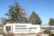
The city has a municipal airport, Ernest A. Love Field, seven miles (11 km) north of the downtown courthouse. Other private companies provide airport shuttles to Phoenix Sky Harbor International Airport.[71][72]
The three main thoroughfares in and around Prescott are Arizona State Route 89A, Arizona State Route 69 and Arizona State Route 89. State Route 89A connects Sedona and Cottonwood to Northern Prescott and meets with State Route 89 near the Airport eventually turning into Pioneer Parkway where it connects to Williamson Valley Road. State Route 69 connects Prescott with Prescott Valley to the east, eventually curving southeast before reaching Interstate 17 at mile marker 262, about 65 miles (105 km) from downtown Phoenix. State Route 89 travels mostly north–south and connects Prescott with Chino Valley and Paulden to the north, continuing northward until it joins Interstate 40 at mile marker 146, Ash Fork.
In 2016 ADOT realigned willow creek road in between State Route 89 and Pioneer Parkway adding a round about on State Route 89 with new access to the Ernest A. Love Field Airport.[73] A future Great western Corridor is planned go on the east side of the Ernest A. Love Field Airport and provide an alternative route to the Airport.[74]
Notable people[]
Nearest cities and towns[]
- Chino Valley
- Groom Creek
- Iron Springs
- Prescott Valley
- Yavapai Hills
Sister cities[]
As of 2015, Prescott has three sister cities:[75]
See also[]
Further reading[]
- August, Jack L. (1998). We Call It 'Preskit': A Guide to Prescott and Central Arizona High Country. Arizona Highways. ISBN 978-0916179571.
- Brody, Richard (October 23, 2017). "The Story That 'Only the Brave' Leaves Out". The New Yorker.
- Henson, Pauline (1965). Founding a wilderness capital, 1864. Prescott, Arizona: Northland Press.
- Wildfang, Frederic (2006). Prescott. Arcadia Publishing. ISBN 978-0-73854858-6.)
References[]
- ^ Jump up to: a b c U.S. Geological Survey Geographic Names Information System: Prescott, Arizona
- ^ Jump up to: a b Prescott, Webmaster at City of. "Prescott History Timeline - City of Prescott, Arizona". Prescott-az.gov. Archived from the original on April 30, 2017. Retrieved November 19, 2017.
- ^ "2019 U.S. Gazetteer Files". United States Census Bureau. Retrieved June 30, 2020.
- ^ "U.S. Census website". United States Census Bureau. Retrieved July 6, 2014.
- ^ Jump up to: a b "Population and Housing Unit Estimates". United States Census Bureau. May 24, 2020. Retrieved May 27, 2020.
- ^ "Prescott". Merriam-Webster Dictionary.
- ^ "Prescott". The American Heritage Dictionary of the English Language (5th ed.). Boston: Houghton Mifflin Harcourt.
- ^ "Prescott". Dictionary.com Unabridged. Random House.
- ^ "Find a County". National Association of Counties. Archived from the original on May 31, 2011. Retrieved June 7, 2011.
- ^ Jump up to: a b Wagoner, Jay J. (1970). Arizona Territory 1863-1912: A Political history. Tucson: University of Arizona Press. p. 36. ISBN 978-0-8165-0176-2.
- ^ "Community Profile for Prescott Valley". Arizona Commerce Authority. Archived from the original on July 13, 2016. Retrieved June 12, 2019.
- ^ United States Geological Survey (USGS). "United States Geological Survey Topographic Map" Archived December 1, 2017, at the Wayback Machine. TopoQuest. Retrieved March 17, 2013.
- ^ Wagoner, Jay J. (1970). Arizona Territory 1863-1912: A Political history. Tucson: University of Arizona Press. p. 36,38. ISBN 978-0-8165-0176-2.
- ^ Wagoner, Jay J. (1970). Arizona Territory 1863-1912: A Political history. Tucson: University of Arizona Press. p. 70. ISBN 978-0-8165-0176-2.
- ^ Wagoner, Jay J. (1970). Arizona Territory 1863-1912: A Political history. Tucson: University of Arizona Press. p. 113. ISBN 978-0-8165-0176-2.
- ^ Wagoner, Jay J. (1970). Arizona Territory 1863-1912: A Political history. Tucson: University of Arizona Press. p. 245. ISBN 978-0-8165-0176-2.
- ^ Jump up to: a b MacKell Collins, Jan. Wild Women of Prescott Arizona.
- ^ "Ancestry.com".
- ^ Roberts, Gary L. Doc Holliday: The Life and Legend.
- ^ https://www.museumofindigenouspeople.org/about-smoki
- ^ "Prescott Real Estate | Feature Your Prescott Home". Prescott Real Estate for Sale. Archived from the original on April 28, 2016. Retrieved April 27, 2016.
- ^ Prescott, Webmaster at City of. "Trails – City of Prescott, Arizona". Cityofprescott.net. Archived from the original on April 28, 2016. Retrieved April 27, 2016.
- ^ "Goldwater Lake | Prescott Arizona". Arizona-leisure.com. Archived from the original on April 21, 2016. Retrieved April 27, 2016.
- ^ "Prescott National Forest – Recreation Area". Fs.usda.gov. Archived from the original on May 13, 2016. Retrieved April 27, 2016.
- ^ "Prescott National Forest – Granite Basin Boating Site". Fs.usda.gov. Archived from the original on May 13, 2016. Retrieved April 27, 2016.
- ^ "Paying the Price for Cleaner Water". Prescott Creeks. December 17, 2010. Retrieved September 10, 2019.
- ^ Marr, Carrie (June 2008). Contaminants in Fish and Wildlife of Lynx Lake, Arizona (PDF) (Report). Department of the Interior, U.S. Fish and Wildlife Service, Region 2. pp. 1–2. Archived (PDF) from the original on July 6, 2017. Retrieved September 10, 2019.
- ^ Jump up to: a b "Data Tools: 1981–2010 Normals". National Oceanic and Atmospheric Administration (NOAA). Archived from the original on July 14, 2014. Retrieved August 26, 2014.
- ^ Jump up to: a b "Monthly Averages for Prescott, Arizona". The Weather Channel. Archived from the original on June 29, 2013. Retrieved August 26, 2014.
- ^ "Climate of Prescott, Arizona" (PDF). Wrh.noaa.gov. Archived from the original (PDF) on October 24, 2005. Retrieved November 19, 2017.
- ^ "NOWData - NOAA Online Weather Data". National Oceanic and Atmospheric Administration. Retrieved June 29, 2021.
- ^ "Summary of Monthly Normals 1991-2020". National Oceanic and Atmospheric Administration. Retrieved June 29, 2021.
- ^ "North American Monsoon Experiment". www.eol.ucar.edu. Archived from the original on December 15, 2018. Retrieved December 14, 2018.
- ^ "Monsoon storms bring lightning, ignitions result". Arizona Emergency Information Network. July 10, 2018. Archived from the original on December 15, 2018. Retrieved December 14, 2018.
- ^ "Prescott, Arizona – Climate Summary". wrcc.dri.edu. Archived from the original on April 16, 2019. Retrieved December 14, 2018.
- ^ Conner, Daniel Ellis (February 2016). Joseph Reddeford Walker and the Arizona Adventure. University of Oklahoma Press. ISBN 9780806154077.
- ^ "Arizona's mining history: Danger for many, riches for a few". azcentral. Retrieved December 26, 2018.
- ^ U.S. Geological Survey Professional Paper. U.S. Government Printing Office. 1965.
- ^ Neary, Daniel G.; et al. (December 2012). "Synthesis of Upper Verde River Research and Monitoring" (PDF). General Technical Report RMRS-GTR-291: 24. Archived (PDF) from the original on August 14, 2017. Retrieved December 14, 2018.
- ^ Honker, Andrew M. (2002). "'A Terrible Calamity has Fallen Upon Phoenix': The 1891 Flood and Salt River Valley Reclamation". The Journal of Arizona History. 43 (2): 109–132. JSTOR 41696696.
- ^ "The worst floods in Arizona in the 20th century..." UPI. Archived from the original on December 15, 2018. Retrieved December 14, 2018.
- ^ "1983 flood ranks among Prescott's worst". The Daily Courier. Archived from the original on December 15, 2018. Retrieved December 14, 2018.
- ^ Lucas, Beth. "3 deaths linked to Arizona floods". East Valley Tribune. Retrieved December 14, 2018.
- ^ "Mayer evacuation lifted following flash flooding". KNXV. August 2, 2018. Archived from the original on December 15, 2018. Retrieved December 14, 2018.
- ^ "Prescott Map Revision". www.ycflood.com. Archived from the original on December 15, 2018. Retrieved December 14, 2018.
- ^ "FEMA Map Revisions". FEMA. Archived from the original on December 15, 2018. Retrieved December 14, 2018.
- ^ "Census of Population and Housing". Census.gov. Retrieved June 4, 2016.
- ^ Simpson, Chad (March 10, 2002). "Gateway opens for business – Shoppers rush to welcome regional mall". The Daily Courier. Retrieved February 14, 2020.
- ^ "Directory Search Results". Chamberorganizer.com. Archived from the original on September 11, 2016. Retrieved August 30, 2016.
- ^ Prescott Area Geological Field Guide, 1999, prepared for Earth Science Week. Copy available at Yavapai College library.
- ^ Holland, Catherine (July 1, 2015). "The Bird Cage on Whiskey Row". Arizona Republic. Archived from the original on July 6, 2015. Retrieved January 13, 2017.
- ^ Leadem, Rose (January 12, 2017). "These Are the Oldest Businesses in Every State". Entrepreneur. Archived from the original on January 16, 2017. Retrieved January 13, 2017.
- ^ A volunteer docent statement from the free official downtown Prescott guided historical and architectural tour claims this is the origin of the phrase, "Where in the Sam Hill did you get that?". This may not be accurate, since "Sam Hill" is also a euphemistic reference to Hell predating Prescott, being a polite way of saying "Where in the Hell did you get that?". However, there was indeed a Sam Hill Hardware store, attested to by the bronze letters embedded in the concrete sidewalk spelling out "SAM HILL" inset in the sidewalk at each boundary of the property.
- ^ "Prescott, Arizona Golf Courses". golf link. Archived from the original on March 22, 2014. Retrieved June 10, 2015.
- ^ [1][dead link]
- ^ [2] Archived April 3, 2015, at the Wayback Machine
- ^ "Prescott's total of sober-living homes drops below 30". Archived from the original on October 16, 2018. Retrieved October 16, 2018.
- ^ "Do DIY : Arizona". Dodiy.org. Retrieved August 11, 2016.[permanent dead link]
- ^ "Elks.org : Lodge #330 Home". www.elks.org. Archived from the original on September 27, 2018. Retrieved September 27, 2018.
- ^ "Preserve America Community: Prescott, Arizona". Preserveamerica.gov. Archived from the original on December 2, 2016. Retrieved November 19, 2017.
- ^ Dozen Distinctive Destinations - Prescott, AZ: http://www.preservationnation.org/travel-and-sites/sites/southwest-region/prescott-az-2006.html Archived March 31, 2012, at the Wayback Machine
- ^ "Yavapai County Courthouse Plaza: Prescott, Arizona". American Planning Association. Archived from the original on September 11, 2017. Retrieved November 19, 2017.
- ^ Meghan Sarr / by the Editors. 2012, Feb. Top Ten True Western Towns. True West. p78.
- ^ Pandolfi, Keith (February 9, 2012). "Pine Crest Historic District, Prescott, Arizona | Best Old House Neighborhoods 2012: The West | Photos | Home & Real Estate". This Old House. Archived from the original on April 4, 2012. Retrieved August 17, 2012.
- ^ "Leadership - Council". Cityofprescott.net. Archived from the original on May 6, 2018. Retrieved July 31, 2014.
- ^ Prescott, Webmaster at City of. "City Leadership - City of Prescott, Arizona". Prescott-az.gov. Archived from the original on August 11, 2016. Retrieved November 19, 2017.
- ^ Jump up to: a b c d "Celebration marks 99 years at Miller Valley school". Dcourier.com. Archived from the original on February 26, 2017. Retrieved February 26, 2017.
- ^ "Kestrel High School". Kestrelhighschool.org. Archived from the original on October 2, 2017. Retrieved November 19, 2017.
- ^ "AZ Dept of Education". Ade.state.az.us. Archived from the original on March 29, 2018. Retrieved November 19, 2017.
- ^ Hutson, Nanci (February 1, 2018). "Oldest school in Arizona gets a major makeover: Prescott's Washington School gets touch of the new, while respecting its past". The Daily Couriers. Archived from the original on February 1, 2018. Retrieved February 2, 2018.
- ^ "Prescott Shuttle Service - Arizona Shuttle". Arizonashuttle.com. Archived from the original on November 16, 2017. Retrieved November 19, 2017.
- ^ "Phoenix to Prescott - Prescott Shuttle". airportshuttleofphoenix.com. Archived from the original on June 16, 2018. Retrieved June 15, 2018.
- ^ "Overview". azdot.gov. Archived from the original on December 1, 2017. Retrieved November 19, 2017.
- ^ "Archived copy". Archived from the original on April 7, 2017. Retrieved May 2, 2017.CS1 maint: archived copy as title (link)
- ^ "Prescott, Arizona". Sister Cities International. Archived from the original on June 10, 2015. Retrieved June 10, 2015.
External links[]

- City of Prescott website
- City of Prescott tourism website
- Prescott Arizona Chamber of Commerce
- Prescott, Arizona at Curlie
- 135 Years Ago Today a Capital is Born Named Prescott, by Earl Hoagberg, Sharlot Hall Archive & Library, May 1999.
- Many Prescott places take their name from 1850s surveyor, By Harley G. Shaw, harlot Hall Archive & Library, August 2000.
Sister projects[]
 Media related to Prescott, Arizona at Wikimedia Commons
 Prescott, Arizona travel guide from Wikivoyage
- . . 1914.
| show Municipalities and communities of Yavapai County, Arizona, United States |
|---|

| show Authority control |
|---|
- Prescott, Arizona
- Cities in Yavapai County, Arizona
- County seats in Arizona
- Former colonial and territorial capitals in the United States
- Populated places established in 1864
- Cities in Arizona
- Metropolitan areas of Arizona