Camp Verde, Arizona
Camp Verde, Arizona | |
|---|---|
 Location of Camp Verde in Yavapai County, Arizona | |
 Camp Verde, Arizona Location in the United States | |
| Coordinates: 34°34′0″N 111°51′22″W / 34.56667°N 111.85611°WCoordinates: 34°34′0″N 111°51′22″W / 34.56667°N 111.85611°W | |
| Country | United States |
| State | Arizona |
| County | Yavapai |
| Government | |
| • Mayor | Dee Jenkins |
| Area | |
| • Total | 43.13 sq mi (111.70 km2) |
| • Land | 43.12 sq mi (111.67 km2) |
| • Water | 0.01 sq mi (0.03 km2) |
| Elevation | 3,147 ft (959 m) |
| Population | |
| • Total | 10,873 |
| • Estimate (2019)[1] | 11,187 |
| • Density | 259.46/sq mi (100.18/km2) |
| Time zone | UTC-7 (MST) |
| ZIP code | 86322 |
| Area code(s) | 928 |
| FIPS code | 04-09690 |
| GNIS feature ID | 27213 |
| Website | Town of Camp Verde |


Camp Verde (Yavapai: ʼMatthi:wa; Western Apache: Gambúdih[4]) is a town in Yavapai County, Arizona, United States. As of the 2010 census, the population of the town is 10,873.[2]
The town hosts an annual corn festival in July, sponsored and organized by Hauser and Hauser Farms. Other annual festivals include Fort Verde Days (October); the Pecan, Wine and Antiques Festival (February); and the Crawdad Festival (June).[5]
Geography[]
The 42.6 sq mi (110 km2) town is bisected by I-17, extending 8 miles (13 km) to the west and 10 miles (16 km) to the east of the interstate. Highway 260 connects Camp Verde with Payson to the east and Cottonwood to the west. Three freeway exits provide local access: Exits 285, 287, and 289. The town's historic downtown is approximately 1 mile (1.6 km) from I-17 and contains a grocery store, physician facilities, shopping, dining, historical museum, Fort Verde State Historic Park, chamber of commerce/visitor center and town offices. Camp Verde is located at 34°34′0″N 111°51′22″W / 34.56667°N 111.85611°W (34.5667, -111.8562).[6]
According to the United States Census Bureau, the town has a total area of 42.6 square miles (110 km2), of which 42.6 square miles (110 km2) is land and 0.02% is water. Camp Verde is in the Verde River valley. To the southwest lie the Black Hills mountain range. Camp Verde is surrounded by Prescott National Forest. The Mogollon Rim is just north of the town and forms the southwestern edge of the large, geologically ancient Colorado Plateau.
Demographics[]
| Historical population | |||
|---|---|---|---|
| Census | Pop. | %± | |
| 1980 | 3,824 | — | |
| 1990 | 6,243 | 63.3% | |
| 2000 | 9,451 | 51.4% | |
| 2010 | 10,873 | 15.0% | |
| 2019 (est.) | 11,187 | [1] | 2.9% |
| U.S. Decennial Census[7] | |||
As of the census[8] of 2000, there were 9,451 people, 2,611 households, and 2,538 families residing in the town. The population density was 222.0 people per square mile (85.7/km2). There were 3,969 housing units at an average density of 93.2 per square mile (36.0/km2). The racial makeup of the town was 85.1% White, 0.4% Black or African American, 7.3% Native American, 0.2% Asian, 0.1% Pacific Islander, 4.7% from other races, and 2.2% from two or more races. 10.9% of the population were Hispanic or Latino of any race.
There were 2,611 households, out of which 27.4% had children under the age of 18 living with them, 55.9% were married couples living together, 9.8% had a female householder with no husband present, and 29.7% were non-families. 24.3% of all households were made up of individuals, and 11.8% had someone living alone who was 65 years of age or older. The average household size was 2.52 and the average family size was 2.97.
In the town, the population was spread out, with 24.0% under the age of 18, 7.2% from 18 to 24, 23.0% from 25 to 44, 25.3% from 45 to 64, and 20.5% who were 65 years of age or older. The median age was 42 years. For every 100 females, there were 101.5 males. For every 100 females age 18 and over, there were 100.2 males.
The median income for a household in the town was $31,868, and the median income for a family was $37,049. Males had a median income of $30,104 versus $20,306 for females. The per capita income for the town was $15,072. About 9.5% of families and 14.0% of the population were below the poverty line, including 21.2% of those under age 18 and 6.1% of those age 65 or over.
Tourism[]
Tourist attractions include the nearby Montezuma Castle National Monument located in Verde Valley. In the town is Fort Verde State Historic Park, and Out of Africa Wildlife Park. The , operated by the Yavapai-Apache Nation Indian tribe, is an important gambling destination for north and central Arizona. Fort Verde State Historic Park is located in Camp Verde's Historic Downtown approximately 1-mile (1.6 km) from all three Camp Verde exits.
Education[]
Camp Verde Unified School District serves the community.
In popular culture[]
The Marvel Comics superhero characters James and John Proudstar are from a reservation in Camp Verde.
The 1977 horror movie Kingdom of the Spiders was filmed in Camp Verde.
In the 2011 film Paul, Simon Pegg and Nick Frost plan to visit Camp Verde as a UFO hot spot along with Rachel, Nevada, Area 51, Apache Junction, Arizona and Roswell, New Mexico.
In Cable #7, Camp Verde is a bunker headquarters of the X-Force.
Historic places[]
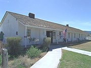
The main Administration Building of Fort Verde was built in 1871 and is located at 125 E. Hollamon St. It contained the main offices from which the decisions as to the operations of the fort were made. It now houses the Visitor Center of the Fort Verde Museum and contains exhibits, period artifacts from military life, and history on the Indian Scouts and Indian Wars era. It is listed in the National Register of Historic Places, reference #71000120.
The historic Commanding Officer Quarters in Fort Verde was built in 1871 and is in the grounds of the Fort Verde Museum located at 125 E. Hollamon St.

The historic Bachelor Officers’ Quarters in Fort Verde was built in 1871.

The historic Doctor’s & Surgeons Quarters in Fort Verde was built in 1871.

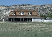
The Wingfield, Hank and Myrtle, Homestead, a.k.a." Crooked "H" Ranch House", was built in 1917 and is located at 806 E. Quaterhorse Ln. It was listed in the National Register of Historic Places in 1999, reference #99000857.

The Don Bell House was built in 1917 and is located at 2530 Anupaya Ln. It was listed in the National Register of Historic Places in 2004, reference #04000513
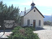
The Clear Creek Church was built in 1898 and is located on Clear Creek Road 3.5 mi. SE of Camp Verde. The builders placed in the cornerstone of the building a bible and a $5 gold piece (which was chiseled away in the 1920s). It was Camp Verde’s only church until 1913, when it was transformed into the city’s one-room schoolhouse. In 1946, the church was abandoned. Today Clear Creek Church is looked after by the Camp Verde Historical Society. It was listed in the National Register of Historic Places on August 6, 1975, reference #75000362.[9]

The George Hance House was built in 1916 and is located at 229 Coppinger Street. George Hance was a veteran of the American Civil War who served as Camp Verdes first postmaster. For almost 30 years, George Hance served as the unincorporated community's unofficial mayor. Hance was also a Justice of the Peace, notary public and cattleman. The house is now a museum and is owned by the Camp Verde Historical Society. It is located in the Fort Verde District, which was added to the National Register of Historic Places in 1971, reference #71000120.[10]


References[]
- ^ Jump up to: a b "Population and Housing Unit Estimates". Retrieved May 21, 2020.
- ^ Jump up to: a b "U.S. Census website". United States Census Bureau. Retrieved 2014-08-05.
- ^ "2019 U.S. Gazetteer Files". United States Census Bureau. Retrieved June 30, 2020.
- ^ William J. de Reuse (2006). A Practical Grammar of the San Carlos Apache Language. Lincom Europa.
- ^ Allen, Carol L. (2017). "Verde Valley Arizona - An Arizona Treasure Awaits Your Visit" (PDF). Western outdoor times.
- ^ "US Gazetteer files: 2010, 2000, and 1990". United States Census Bureau. 2011-02-12. Retrieved 2011-04-23.
- ^ "Census of Population and Housing". Census.gov. Retrieved June 4, 2016.
- ^ "U.S. Census website". United States Census Bureau. Retrieved 2008-01-31.
- ^ Clear Creek Church Archived 2014-02-26 at the Wayback Machine
- ^ "George Hance: Majordomo of the Verde Valley". Archived from the original on 2014-03-19. Retrieved 2014-03-18.
- ^ National Register of Historic Places, Yavapai County
- ^ Camp Verde Historical Society
External links[]
- Camp Verde Official website
- Historic American Buildings Survey (HABS) No. AZ-26, "Camp Verde, Officer's House, Camp Verde, Yavapai County, AZ", 1 photo
- The Camp Verde Bugle – Local newspaper
- The Camp Verde Journal – Local newspaper
| show Municipalities and communities of Yavapai County, Arizona, United States |
|---|

| show Authority control |
|---|
- Towns in Yavapai County, Arizona
- Historic American Buildings Survey in Arizona
- Populated places established in 1986