Buner District
Buner
بونېر Buneri | |
|---|---|
| بونیر | |
 Babe e Madinatul Awlia. Babe e Buner Karakar Pass | |
| Nickname(s): Gul Da Namair[4] | |
| Motto(s): The Land of sufis اولیاء کی سرزمین | |
 Location in the province of Khyber Pakhtunkhwa | |
| Country | Pakistan |
| Province | Khyber Pakhtunkhwa |
| District | 1998 |
| Headquarters | Daggar[2] |
| Government | |
| • Deputy Commissioner | Nasrullah Khan Yousafzai |
| Area | |
| • Total | 1,865 km2 (720 sq mi) |
| Population | |
| • Total | 897,319 |
| • Density | 480/km2 (1,200/sq mi) |
| Demonym(s) | Buneri |
| Time zone | UTC+5 (PKT) |
| Postal code of Daggar | 19290 |
| Area code(s) | 0939 |
| Number of tehsils | 6 |
| Number of Union Councils | 27[1] |


Buner District (Pashto: بونیر ولسوالۍ, Urdu: ضِلع بونیر) is a district in Malakand Division of Khyber Pakhtunkhwa province in Pakistan. Before becoming a district in 1991, it was a tehsil within Swat District.[5]
History[]

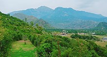
The Buner Valley lies on the Peshawar valley border of the Khyber Pakhtunkhwa. It is a small mountain valley, dotted with villages and divided into four sub-divisions. The and the Ilam range divide it from the Swat Valley, the Sinawar range from Yusafzai, the Guru mountains from the Mardan Valley, and the Duma range from the Puran Valley.[6]
During the 1580s, many Yusufzais and Mandanrs rebelled against the Mughal Empire.[7] In late 1585, Mughal Emperor Akbar sent military forces under Zain Khan Koka and Birbal to crush the rebellion. In February 1586, about 8,000 Mughal soldiers, including Birbal, were killed near the Karakar Pass by the Yusufzai lashkar, led by Kalu Khan. This was the greatest disaster faced by the Mughal Army during Akbar's reign.[8]
During the 19th century, the inhabitants of Buner rose twice against the British Raj.[9]
In April 2009, the Tehrik-i-Taliban Pakistan seized control of Buner, after a brief battle with local residents. Strict rules were reportedly being enforced, including the elimination of video stores, bans on cutting beards, and the prevention of women from appearing in many public places.[10] On 29 April the government responded to the Taliban by sending the army to the region and dropping parachutists by helicopter.[11] By the end of May 2009, almost all of Buner was cleared of the Taliban.[12]
- Elum Ghar
 ELUM MOUNTAIN

Administration[]
Buner Tehsils[]
Buner District is currently subdivided into 6 Tehsils.
National assembly[]
This district is represented by one elected MNA (Member of National Assembly) in Pakistan National Assembly. Its constituency is NA-28.[13]
| Election | Member | Party |
|---|---|---|
| 2002 | Sher Akbar Khan | PPP (S) |
| 2008 | Istiqbal Khan | ANP |
| 2013 | Sher Akbar Khan | JI |
| 2018 | Sher Akbar Khan | PTI |
Provincial assembly[]
The district has three constituencies in the Provincial Assembly of Khyber Pakhtunkhwa[14] and one in the National Assembly of Pakistan.
| Member of Provincial Assembly | Party Affiliation | Constituency | Year |
|---|---|---|---|
| Riaz Khan | Pakistan Tehreek-e-Insaf | PK-20 Buner-I | 2018 |
| Syed Fakhr e Jehan | Pakistan Tehreek-e-Insaf | PK-21 Buner-II | 2018 |
| Sardar Hussain Babak | Awami National Party | PK-22 Buner-III | 2018 |
Education[]
Notable People[]
- Munair Buneri (Pashto-Language poet)
- Azam Buneri (Pashto-Language poet)
- Zamarud Buneri (Host of Golf Time
- Akbar Ali Surawal AVT Khyber[15]
Largest villages[]
- Torwarsak is the most populated Town in Buner which population is about 35,165 in 2018
 Torwarsak village in 2020
 - Totalai is the second populated town which population is 24,562
- Rega, Buner third at 23,726
- Ellai is fourth at 23,678[16]

See also[]
- Khyber Pakhtunkhwa
- Rustam, Mardan
- Mardan
- Swat
- University of Buner
References[]
- ^ "Village/Neighbourhood Council". lgkp.gov.pk. Archived from the original on 2018-02-26. Retrieved 2017-07-03.
- ^ "Uncertainty rules Pakistan's Buner district" Archived 2014-07-14 at the Wayback Machine, Radio Nertherlands Worldwide
- ^ "DISTRICT AND TEHSIL LEVEL POPULATION SUMMARY WITH REGION BREAKUP: KHYBER PAKHTUNKHWA" (PDF). Pakistan Bureau of Statistics. 2018-01-03. Archived from the original (PDF) on 2018-04-24. Retrieved 2018-04-23.
- ^ https://tnnurdu.com/kp/39927/
- ^ 1998 District Census report of Buner. Census publication. 98. Islamabad: Population Census Organization, Statistics Division, Government of Pakistan. 2000.
- ^ One or more of the preceding sentences incorporates text from a publication now in the public domain: Chisholm, Hugh, ed. (1911). "Buner". Encyclopædia Britannica. 4 (11th ed.). Cambridge University Press. p. 798.
- ^ "Imperial Gazetteer2 of India, Volume 19– Imperial Gazetteer of India". Digital South Asia Library. p. 152. Retrieved 22 April 2015.
- ^ Richards, John F. (1993). The Mughal Empire. The New Cambridge History of India. Cambridge University Press. pp. 50–51. ISBN 9780521566032.
- ^ Chisholm 1911.
- ^ Taliban Exert Influence in Pakistan: April 21, 2009
- ^ Pakistani forces seize main town of Buner district from Taliban
- ^ "90% Buner Cleared: May 27, 2009". Archived from the original on 2012-03-18. Retrieved 2009-06-12.
- ^ http://ecp.gov.pk/GE.aspx
- ^ Constituencies and MPAs – Website of the Provincial Assembly of the NWFP Archived April 22, 2009, at the Wayback Machine
- ^ https://khybernews.tv/khaleej-nama-with-zamarud-buneri-ep-253-5th-june-2020-khyber-news/?amp
- ^ https://www.politicpk.com/bunner-district-population-of-cities-towns-and-villages-2017-2018
External links[]
- Gaju Khan Yusufzai
- Yusufzai at Khyber.org
| hide Administrative divisions of Buner District | ||
|---|---|---|
| Capital | ||
| Tehsils |
| |
| Union councils | ||
| show Districts of Khyber Pakhtunkhwa |
|---|

| show Authority control |
|---|

- Buner District
- Districts of Khyber Pakhtunkhwa