Upper Dir District
Upper Dir District
ضلع دیرِ بالا | |
|---|---|
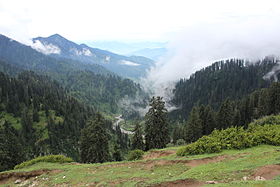
 Jahaz Banda in Upper Dir's Kumrat valley | |
 Location of Upper Dir District (highlighted in red) in the Khyber Pakhtunkhwa map | |
| Country | |
| Province | |
| Established | 1996 |
| Headquarters | Dir |
| Government | |
| • Chief Commissioner | N/A |
| • Deputy Commissioner | N/A |
| Area | |
| • District | 3,699 km2 (1,428 sq mi) |
| Population | |
| • District | 946,421 |
| • Density | 260/km2 (660/sq mi) |
| • Urban | 44,165 |
| • Rural | 902,256 |
| Time zone | UTC+5 (PST) |
| Number of Tehsils | 6 |
| Main language | Pashto (93%)[2]:21 |
| Website | http://www.upperdir.pk/ |
Upper Dir District (Pashto: بر دير ولسوالۍ, Urdu: ضِلع دیر بالا) is a district in Malakand Division of Khyber Pakhtunkhwa province in Pakistan. The town of Dir is the district headquarters. Badogai Pass connects it to Utror.
At the time of independence, Dir was a princely state ruled by Nawab Shah Jehan Khan. It was merged with Pakistan in 1969 and later on declared as a district in 1970. In 1996, the Dir District was divided into Upper and Lower Dir districts. This district is situated in the northern part of Pakistan. It borders Chitral district and Afghanistan on the north and northwest and Swat district to the east, and on the south by Lower Dir District.[3]

History[]
The British Raj honored Muhammad sharif Khan as Nawab of Dir in 1898 . By declaring his allegiance to the British Raj, Khan/Nawab, once exiled to Afghanistan by Umara Khan Mastkhel was seated as Nawab of Dir. He was succeeded by his son Nawab Aurang Zeb in 1904, who ruled until his death in 1925. His son Sir Shah Jehan succeeded him and ruled the state for 35 long years. He was dethroned and kept in house arrest in Lahore until his death in 1966 . He was succeeded by Mohammad Shah Khisro Khan. He left all the business at the mercy of his advisor, a man deputed by the Govt:of Pakistan to mould the state into a settled district through gradual implementation of laws. In 1969, it was merged as a district with Khyber Pakhtunkhwa. In 1996, Dir District was divided into two districts-Lower and Upper Dir- with Timergara and Dir as their respective headquarters.
Administration[]
Upper Dir District has 3 tehsils.[4]
National Assembly[]
This district is represented by one elected MNA (Member of National Assembly) in Pakistan National Assembly. Its constituency is NA-5 (Upper Dir).[5]
| Member of National Assembly | Party Affiliation | Year |
|---|---|---|
| Molana Asad Ullah | Muttahida Majlis-e-Amal | 2002 |
| Najum-din Khan | Pakistan Peoples Party | 2008 |
| Sahibzada Sebgat Ullah | Pakistan Tehreek-e-Insaf | 2018 |
Provincial Assembly[]
| Member of Provincial Assembly | Party Affiliation | Constituency | Year |
|---|---|---|---|
| Malak Badsha Saleh | Pakistan Peoples Party Parliamentarians | PK-10 Upper Dir-I | 2018 |
| Sahibzada Sanaullah | Pakistan Peoples Party Parliamentarians | PK-11 Upper Dir-II | 2018 |
| Inayat Ullah | Muttahida Majlis-e-Amal | PK-12 Upper Dir-III | 2018 |
Towns[]
Except for Dir and a number of rapidly growing bazaar towns along the main roads, the population is rural, scattered in more than 1200 villages in the deep narrow valleys of the Panjkora and its tributaries.
Of these, notable villages are
Division of Dir[]
Popular places[6]
- Qashqaray
- Kumrat Valley
- Kalkot
- Sheringal
- Doog Dara
- Ushirai Dara
- Barawal
- Ganori
- Gandigar
- Nowra
- sawni
- kakad
- Wari City
See also[]
References[]
| Wikimedia Commons has media related to Upper Dir District. |
- ^ "DISTRICT AND TEHSIL LEVEL POPULATION SUMMARY WITH REGION BREAKUP: KHYBER PAKHTUNKHWA" (PDF). Pakistan Bureau of Statistics. 3 January 2018. Retrieved 23 April 2018.
- ^ 1998 District Census report of Upper Dir. Census publication. 104. Islamabad: Population Census Organization, Statistics Division, Government of Pakistan. 2000.
- ^ http://paiman.jsi.com/Resources/Docs/district-health-profile-upperdir.pdf
- ^ https://www.lgkp.gov.pk/districts/district-dir-upper/
- ^ "Archived copy". Archived from the original on 10 November 2015. Retrieved 6 November 2015.CS1 maint: archived copy as title (link)
- ^ http://www.pdma.gov.pk/documents/District_Tehsil_and_Union_code_Reference_Map_Upper_Dir.pdf[permanent dead link]
| hide Districts of Khyber Pakhtunkhwa | ||
|---|---|---|
Provincial capital: Peshawar | ||
| Bannu |  | |
| Dera Ismail Khan | ||
| Hazara | ||
| Kohat | ||
| Malakand | ||
| Mardan | ||
| Peshawar | ||
| show Administrative divisions of Upper Dir District |
|---|
| Authority control |
|---|
Coordinates: 35°12′15″N 71°52′20″E / 35.20417°N 71.87222°E

- Upper Dir District
- Districts of Khyber Pakhtunkhwa