Cam Lộ District
show This article may be expanded with text translated from the corresponding article in Vietnamese. (March 2009) Click [show] for important translation instructions. |
Cam Lộ District
Huyện Cam Lộ | |
|---|---|
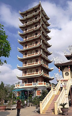 Cam Lo Pagoda is the temple with the highest stupa in Vietnam, setting a record on May 21, 2016. | |
 Seal | |
| Country | |
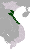
| Region | North Central Coast |
| Province | Quảng Trị |
| Capital | Cam Lộ |
| Area | |
| • Total | 134 sq mi (347 km2) |
| Population (2003) | |
| • Total | 46,231 |
| Time zone | UTC+07:00 (Indochina Time) |
Cam Lộ (![]() listen) is a rural district of Quảng Trị Province in the North Central Coast region of Vietnam. As of 2003 the district had a population of 46,231.[1] The district covers an area of 347 km². The district capital lies at Cam Lộ.[1]
listen) is a rural district of Quảng Trị Province in the North Central Coast region of Vietnam. As of 2003 the district had a population of 46,231.[1] The district covers an area of 347 km². The district capital lies at Cam Lộ.[1]
Administration subdivisions[]
The district includes a townlet Cam Lộ (capital) and eight rural communes (xã): Cam Thành, Cam An, Cam Thanh, Cam Thuỷ, Cam Tuyền, Cam Hiếu, Cam Chính, Cam Nghĩa.
References[]
- ^ Jump up to: a b "Districts of Vietnam". Statoids. Retrieved March 20, 2009.
| show Districts of Vietnam North Central Coast |
|---|
| Authority control |
|---|
Coordinates: 16°49′01″N 106°57′00″E / 16.817°N 106.950°E

This article about a location in Quảng Trị Province, Vietnam is a stub. You can help Wikipedia by . |
Categories:
- Districts of Quảng Trị Province
- North Central Coast geography stubs