Hà Tĩnh
Hà Tĩnh
Thành phố Hà Tĩnh | |
|---|---|
| Hà Tĩnh City | |
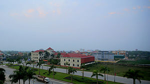 View from the Sailing Tower building | |
 Seal | |
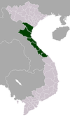
 Hà Tĩnh Location of Hà Tĩnh in Vietnam | |
| Coordinates: 18°20′N 105°54′E / 18.333°N 105.900°E | |
| Country | |
| Province | Hà Tĩnh |
| Upgraded to city | 28 May 2007 |
| Government | |
| • People's Committee President | Nguyễn Văn Quý |
| • People's Association President | Hà Văn Trọng |
| Area | |
| • Total | 5,619 km2 (2,170 sq mi) |
| Population | 202,062 |
| Climate | Am |
| Website | http://hatinhcity.gov.vn |

Hà Tĩnh (Vietnamese: [hâː tǐŋ̟ˀ] (![]() listen)) is a city in Vietnam.[1] It is the capital of Hà Tĩnh Province, and lies in the North Central Coast region. It is located on National Highway 1A. The Vietnamese capital Hanoi is located 340 km north of Hà Tĩnh, Vinh is located 50 km to the north, and Huế is located 314 km to the south. Hà Tĩnh is 12.5 km from the East Sea.
listen)) is a city in Vietnam.[1] It is the capital of Hà Tĩnh Province, and lies in the North Central Coast region. It is located on National Highway 1A. The Vietnamese capital Hanoi is located 340 km north of Hà Tĩnh, Vinh is located 50 km to the north, and Huế is located 314 km to the south. Hà Tĩnh is 12.5 km from the East Sea.
Geography[]
- North borders: Thạch Hà town (via Cày bridge), Cửa Sót river.
- West borders: Thạch Đài Commune, Cày river (Thạch Hà district).
- Southern borders: Cẩm Bình Commune, Cẩm Vịnh Commune (Cẩm Xuyên district).
- Eastern borders: Đồng Môn river (Thạch Hà district, Lộc Hà)
Administrative divisions[]
Hà Tĩnh city consists of 16 administration units: 10 wards and 6 communes:
- Nam Hà ward
- Bắc Hà ward
- Tân Giang ward
- Trần Phú ward
- Nguyễn Du ward
- Hà Huy Tập ward
- Đại Nài ward
- Văn Yên ward
- Thạch Linh ward
- Thạch Quý ward
- Thạch Bình commune
- Thạch Trung commune
- Thạch Môn commune
- Thạch Hạ commune
- Thạch Hưng commune
- Thạch Đồng commune
Education[]
There are many tertiary education institutions such as Hà Tĩnh University, Hà Tĩnh College of Medicine, Nguyễn Du Cultural, Sports and Tourism College, Hà Tĩnh Vocational College of Technology and Vietnam-Germany College of Vocation. Some high schools include Hà Tĩnh Senior High School, Phan Đình Phùng High School and Thành Sen (Lotus City) High School.
Climate[]
| hideClimate data for Hà Tĩnh | |||||||||||||
|---|---|---|---|---|---|---|---|---|---|---|---|---|---|
| Month | Jan | Feb | Mar | Apr | May | Jun | Jul | Aug | Sep | Oct | Nov | Dec | Year |
| Record high °C (°F) | 32.4 (90.3) |
35.8 (96.4) |
38.1 (100.6) |
39.9 (103.8) |
40.2 (104.4) |
40.1 (104.2) |
39.9 (103.8) |
39.7 (103.5) |
38.0 (100.4) |
35.2 (95.4) |
33.4 (92.1) |
29.8 (85.6) |
40.2 (104.4) |
| Average high °C (°F) | 20.6 (69.1) |
20.8 (69.4) |
23.8 (74.8) |
28.2 (82.8) |
32.2 (90.0) |
33.7 (92.7) |
34.3 (93.7) |
33.1 (91.6) |
30.6 (87.1) |
27.6 (81.7) |
24.5 (76.1) |
21.7 (71.1) |
27.6 (81.7) |
| Daily mean °C (°F) | 17.6 (63.7) |
18.1 (64.6) |
20.7 (69.3) |
24.3 (75.7) |
27.8 (82.0) |
29.3 (84.7) |
29.7 (85.5) |
28.7 (83.7) |
26.8 (80.2) |
24.3 (75.7) |
21.4 (70.5) |
18.6 (65.5) |
23.9 (75.0) |
| Average low °C (°F) | 15.6 (60.1) |
16.5 (61.7) |
18.7 (65.7) |
21.9 (71.4) |
24.5 (76.1) |
26.0 (78.8) |
26.1 (79.0) |
25.6 (78.1) |
24.2 (75.6) |
22.0 (71.6) |
19.3 (66.7) |
16.4 (61.5) |
21.4 (70.5) |
| Record low °C (°F) | 7.3 (45.1) |
8.0 (46.4) |
8.2 (46.8) |
13.3 (55.9) |
17.3 (63.1) |
19.5 (67.1) |
22.0 (71.6) |
22.3 (72.1) |
17.0 (62.6) |
15.1 (59.2) |
11.3 (52.3) |
6.8 (44.2) |
6.8 (44.2) |
| Average precipitation mm (inches) | 97 (3.8) |
64 (2.5) |
54 (2.1) |
74 (2.9) |
143 (5.6) |
144 (5.7) |
112 (4.4) |
225 (8.9) |
532 (20.9) |
765 (30.1) |
319 (12.6) |
162 (6.4) |
2,690 (105.9) |
| Average precipitation days | 14.6 | 15.8 | 14.9 | 11.3 | 11.1 | 8.9 | 7.2 | 11.5 | 14.9 | 18.4 | 16.4 | 13.6 | 158.5 |
| Average relative humidity (%) | 91.0 | 92.9 | 91.8 | 88.3 | 81.7 | 76.8 | 73.9 | 79.7 | 86.5 | 88.7 | 88.5 | 88.2 | 85.7 |
| Mean monthly sunshine hours | 77 | 50 | 76 | 137 | 219 | 206 | 233 | 193 | 161 | 135 | 95 | 82 | 1,664 |
| Source: Vietnam Institute for Building Science and Technology[2] | |||||||||||||
Gallery[]
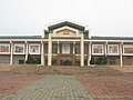
City Cultural Center

See also[]
References[]
- ^ Atlas of the World, Oxford University Press, 2011, p. 236.
- ^ "Vietnam Building Code Natural Physical & Climatic Data for Construction" (PDF). Vietnam Institute for Building Science and Technology. Archived from the original (PDF) on 22 July 2018. Retrieved 31 July 2018.
Coordinates: 18°20′N 105°54′E / 18.333°N 105.900°E
| show Districts of Vietnam North Central Coast |
|---|
| show Authority control |
|---|
This article about a location in Hà Tĩnh Province, Vietnam is a stub. You can help Wikipedia by . |
- Provincial capitals in Vietnam
- Populated places in Hà Tĩnh Province
- Districts of Hà Tĩnh Province
- Cities in Vietnam
- North Central Coast geography stubs