Cao Bằng
Cao Bằng
Thành phố Cao Bằng | |
|---|---|
| Cao Bằng City | |
 | |
 | |
 Cao Bằng Location of in Vietnam | |
| Coordinates: 22°40′00″N 106°15′30″E / 22.66667°N 106.25833°ECoordinates: 22°40′00″N 106°15′30″E / 22.66667°N 106.25833°E | |
| Country | |
| Province | Cao Bằng |
| Area | |
| • Total | 107.6281 km2 (41.5554 sq mi) |
| Population (2019)[1] | |
| • Total | 73 549 |
| Time zone | UTC+7 (ICT) |
| Climate | Cwa |

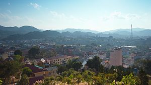
Cao Bằng ([kāːw ɓàŋ] (![]() listen)) is a city in northern Vietnam.[2] It is the capital and largest settlement of Cao Bằng Province. It is located on the bank of the Bằng Giang river, and is around 30 kilometres (19 mi) away from the border with China's Guangxi region. According to the 2019 census, Cao Bằng City has a population of 73 549 people.[1]
listen)) is a city in northern Vietnam.[2] It is the capital and largest settlement of Cao Bằng Province. It is located on the bank of the Bằng Giang river, and is around 30 kilometres (19 mi) away from the border with China's Guangxi region. According to the 2019 census, Cao Bằng City has a population of 73 549 people.[1]
History[]
The area, Cao Bằng (高平; 'high plateau'), was the stronghold of the last years of the Mạc dynasty after their 1592 defeat at the hands of the Trịnh lords. During the 19th century the area was resistant to the Nguyễn government.[3]
The city is also known for the Battle of Cao Bằng, the first major decisive victory of the Việt Minh against the French Army.[4]
Climate[]
| hideClimate data for Cao Bằng | |||||||||||||
|---|---|---|---|---|---|---|---|---|---|---|---|---|---|
| Month | Jan | Feb | Mar | Apr | May | Jun | Jul | Aug | Sep | Oct | Nov | Dec | Year |
| Record high °C (°F) | 32.3 (90.1) |
35.9 (96.6) |
37.1 (98.8) |
38.3 (100.9) |
39.9 (103.8) |
40.5 (104.9) |
38.7 (101.7) |
38.3 (100.9) |
37.8 (100.0) |
36.9 (98.4) |
33.7 (92.7) |
32.3 (90.1) |
40.5 (104.9) |
| Average high °C (°F) | 18.4 (65.1) |
19.3 (66.7) |
23.1 (73.6) |
27.5 (81.5) |
31.0 (87.8) |
32.0 (89.6) |
32.3 (90.1) |
32.1 (89.8) |
31.2 (88.2) |
28.2 (82.8) |
24.3 (75.7) |
20.8 (69.4) |
26.7 (80.1) |
| Daily mean °C (°F) | 13.8 (56.8) |
15.1 (59.2) |
18.8 (65.8) |
22.9 (73.2) |
25.9 (78.6) |
27.0 (80.6) |
27.0 (80.6) |
26.7 (80.1) |
25.4 (77.7) |
22.5 (72.5) |
18.5 (65.3) |
15.1 (59.2) |
21.6 (70.9) |
| Average low °C (°F) | 10.9 (51.6) |
12.3 (54.1) |
15.9 (60.6) |
19.6 (67.3) |
22.3 (72.1) |
23.7 (74.7) |
24.0 (75.2) |
23.5 (74.3) |
21.9 (71.4) |
19.1 (66.4) |
15.2 (59.4) |
11.5 (52.7) |
18.3 (64.9) |
| Record low °C (°F) | −0.9 (30.4) |
1.8 (35.2) |
3.1 (37.6) |
6.6 (43.9) |
13.7 (56.7) |
15.6 (60.1) |
18.2 (64.8) |
16.7 (62.1) |
14.2 (57.6) |
7.2 (45.0) |
3.6 (38.5) |
−1.3 (29.7) |
−1.3 (29.7) |
| Average precipitation mm (inches) | 25 (1.0) |
25 (1.0) |
49 (1.9) |
87 (3.4) |
184 (7.2) |
236 (9.3) |
272 (10.7) |
260 (10.2) |
138 (5.4) |
83 (3.3) |
43 (1.7) |
21 (0.8) |
1,423 (56.0) |
| Average precipitation days | 8.6 | 9.2 | 10.0 | 11.5 | 14.8 | 16.9 | 18.9 | 18.2 | 12.4 | 10.3 | 7.2 | 5.6 | 143.6 |
| Average relative humidity (%) | 80.5 | 80.3 | 79.8 | 79.8 | 79.6 | 82.1 | 84.2 | 85.4 | 83.4 | 81.9 | 81.2 | 79.8 | 81.5 |
| Mean monthly sunshine hours | 65 | 58 | 78 | 115 | 161 | 156 | 176 | 184 | 170 | 141 | 117 | 113 | 1,534 |
| Source: Vietnam Institute for Building Science and Technology[5] | |||||||||||||
References[]
- ^ Jump up to: a b General Statistics Office of Vietnam (2019). "Completed Results of the 2019 Viet Nam Population and Housing Census" (PDF). Statistical Publishing House (Vietnam). ISBN 978-604-75-1532-5.
- ^ http://baodientu.chinhphu.vn/Home/Thanh-lap-thanh-pho-Cao-Bang/20129/149871.vgp
- ^ Bradley Camp Davis, States of banditry: The Nguyen government, bandit rule, and the ... University of Washington - 2008 Page 345 "..much of Lạng Son and Cao Bằng until his death in 1890. His organization, Which connected the aims of the Cần Vương with the tactics of borderlands banditry, Survived him."
- ^ "UQAM | Guerre d'Indochine | CAO BẰNG, BATTLE OF". indochine.uqam.ca. Retrieved 2018-11-16.
- ^ "Vietnam Building Code Natural Physical & Climatic Data for Construction" (PDF). Vietnam Institute for Building Science and Technology. Archived from the original (PDF) on 22 July 2018. Retrieved 3 August 2018.

| show Authority control |
|---|
This article about a location in Cao Bằng Province, Vietnam is a stub. You can help Wikipedia by . |
- Provincial capitals in Vietnam
- Populated places in Cao Bằng Province
- Cities in Vietnam
- Districts of Cao Bằng Province
- Northeast Vietnam geography stubs