Sơn La Province
Sơn La Province
Tỉnh Sơn La | |
|---|---|
  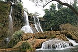    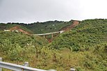  Mường La Mountain • Sơn La Dam • Dải Yếm Waterfall • Bản Phúc Mountain • Mộc Châu Mountain • Quỳnh Nhai Mountain pass • Pha Đin Mountain pass • Sơn La City | |
 Seal | |
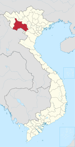 Location of Sơn La within Vietnam | |
 | |
| Coordinates: 21°10′N 104°0′E / 21.167°N 104.000°ECoordinates: 21°10′N 104°0′E / 21.167°N 104.000°E | |
| Country | |
| Region | Northwest |
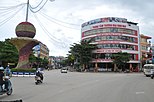
| Capital | Sơn La |
| Subdivision | 1 city, 11 rural districts |
| Government | |
| • Type | Province |
| • Body | Sơn La Provincial People's Council |
| • Chairman of People's Council | Nguyễn Thái Hưng |
| • Chairman of People's Committee | Hoàng Quốc Khánh |
| Area | |
| • Province | 14,123.49 km2 (5,453.11 sq mi) |
| Population (2019)[3] | |
| • Province | 1,248,415 |
| • Density | 88/km2 (230/sq mi) |
| • Urban | 172,861 |
| Ethnic groups | |
| • Thái | 53.61% |
| • Vietnamese[4] | 16.26% |
| • Mông | 16.06% |
| • Mường | 6.78% |
| • Xinh Mun | 2.17% |
| • Others | 5.12% |
| Time zone | UTC+7 (ICT) |
| Area codes | 212 |
| ISO 3166 code | VN-05 |
| Website | www |

Sơn La (![]() listen) is a province in the Northwest region of Vietnam. It borders Laos to the south. The province covers an area of 14,123.49 square kilometres and as of 2019 it had a population of 1,248,415.[3] The population includes Black and White Tai ethnic group.
listen) is a province in the Northwest region of Vietnam. It borders Laos to the south. The province covers an area of 14,123.49 square kilometres and as of 2019 it had a population of 1,248,415.[3] The population includes Black and White Tai ethnic group.
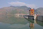
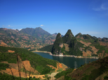
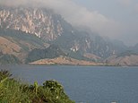
Sơn La Dam, the largest hydroelectric power station in Southeast Asia.[5] is located in this province.
Etymology[]
The province's name derives from Sino-Vietnamese 山羅.
Administrative divisions[]
Sơn La is subdivided into 12 district-level sub-divisions and 204 commune-level sub-divisions:
| Administrative divisions of Sơn La | ||||||||||||||||||||||||||||||||||||||||||||||||||||||||||||||||||
|---|---|---|---|---|---|---|---|---|---|---|---|---|---|---|---|---|---|---|---|---|---|---|---|---|---|---|---|---|---|---|---|---|---|---|---|---|---|---|---|---|---|---|---|---|---|---|---|---|---|---|---|---|---|---|---|---|---|---|---|---|---|---|---|---|---|---|
|
|
|||||||||||||||||||||||||||||||||||||||||||||||||||||||||||||||||
See also[]
References[]
- ^ "Phê duyệt và công bố kết quả thống kê Area đất đai của cả nước năm 2018" [Announcements of area statistics for the whole country in 2018]. Act No. 2908/QĐ-BTNMT of November 13, 2019 (in Vietnamese). Ministry of Natural Resources and Environment (Vietnam). - the data in the report are in ares, rounded to integers
- ^ "STATISTICAL YEARBOOK 2019". General Statistics Office of Vietnam. 2020-06-30.
- ^ Jump up to: a b c General Statistics Office of Vietnam (2019). "Completed Results of the 2019 Viet Nam Population and Housing Census" (PDF). Statistical Publishing House (Vietnam). ISBN 978-604-75-1532-5.
- ^ Also called Kinh people
- ^ "Huge hydro plant starts operation in Vietnam, says official". Intellasia News Services. 2010-12-22. Retrieved 2011-01-22.
External links[]
| show Places adjacent to Sơn La Province |
|---|
| show Authority control |
|---|
This article about a location in Sơn La Province, Vietnam is a stub. You can help Wikipedia by . |
Categories:
- Sơn La Province
- Northwest (Vietnam)
- Provinces of Vietnam
- Northwest Vietnam geography stubs