North Central Coast

Bắc Trung Bộ (literally North Central Region, and often translated as North Central Coast) is one of the regions of Vietnam. It consists of six provinces: Thanh Hóa, Nghệ An, Hà Tĩnh, Quảng Bình, Quảng Trị, Thừa Thiên–Huế. The last two provinces were the northernmost provinces of South Vietnam until 1975. In the Nguyễn dynasty, this area (except Thừa Thiên) was known as Hữu Trực Kỳ (the area located in the left of Thừa Thiên).
Provinces[]
| Province- Level Division |
Capital | Population (Census April 1, 2009) |
Area (km2) |
|---|---|---|---|
| Hà Tĩnh | Hà Tĩnh | 1,230,300 | 6,025.6 |
| Nghệ An | Vinh | 2,919,200 | 16,490.7 |
| Quảng Bình | Đồng Hới | 848,000 | 8,065.3 |
| Quảng Trị | Đông Hà | 599,200 | 4,747.0 |
| Thanh Hóa | Thanh Hóa | 3,405,000 | 11,133.4 |
| Thừa Thiên–Huế | Huế | 1,088,700 | 5,062.6 |
History[]
Four of the northernmost provinces of the north central coast region, fell within the communist-ruled North Vietnam (17th parallel), were hostile to the United States and ARVN forces throughout the Vietnam War as it was a NLF stronghold.
Culture[]
This region features three out of UNESCO's seven World Heritage Sites in Vietnam, namely: Phong Nha-Kẻ Bàng National Park (2003) under Natural, and Complex of Huế Monuments (1993) and Citadel of the Hồ Dynasty (2011) under Cultural.[2]
Economy[]
The Bắc Trung Bộ region has the second lowest GDP per capita in the country, while the Northwest (Tây Bắc) region ranks the lowest GDP per capita.
Demographics[]
This section needs expansion. You can help by . (June 2008) |
The monthly income for the North Central Coast is 902,900 VND compared with the whole country of 1,387,200 VND (2010).[3]
The percentage of households with permanent housing for the North Central Coast is 75.6% compared with the whole country of 49.2% (2010).[4]
The household size for the North Central Coast is 3.94 (2010).[5]
The percentage of the population aged 15 years old and over obtained the following education in the North Central Coast: Never go to school 5.2%; Primary 19.3%; Lower secondary 33.1%; Upper secondary 17.3%; College, University 5.2%; Postgraduate 0.1% (2010).[6]
The percentage of the population aged 15 years old and over work in the following industries: Agriculture 59.9%; Forestry 2.1%; Fishery 1.8%; Industry 7.5%; Construction 6.6%; Trade 7.7%; Services 14.5% (2010).[7]
| Wikimedia Commons has media related to Bắc Trung Bộ Region (North Central Coast). |
References[]
- ^ "General Statistics Office Of Vietnam". Gso.gov.vn. Retrieved 2013-06-22.
- ^ UNESCO World Heritage Centre. "Viet Nam - UNESCO World Heritage Centre". Whc.unesco.org. Retrieved 2013-06-22.
- ^ http://www.gso.gov.vn/Modules/Doc_Download.aspx?DocID=13386
- ^ http://www.gso.gov.vn/Modules/Doc_Download.aspx?DocID=13389
- ^ http://www.gso.gov.vn/Modules/Doc_Download.aspx?DocID=13382
- ^ http://www.gso.gov.vn/Modules/Doc_Download.aspx?DocID=13383
- ^ http://www.gso.gov.vn/Modules/Doc_Download.aspx?DocID=13391
Districts of Vietnam North Central Coast | ||
|---|---|---|
| Thanh Hóa Province | 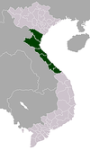 | |
| Nghệ An Province | ||
| Hà Tĩnh Province | ||
| Quảng Bình Province |
| |
| Quảng Trị Province | ||
| Thừa Thiên Huế Province |
| |
※ denotes provincial seat. | ||
Coordinates: 16°28′N 107°35′E / 16.467°N 107.583°E

This article about a location in Vietnam is a stub. You can help Wikipedia by . |
- North Central Coast
- Regions of Vietnam
- Geography of Vietnam
- Vietnam geography stubs