Hương Sơn District
This article may be expanded with text translated from the corresponding article in Vietnamese. (March 2009) Click [show] for important translation instructions.
|
Hương Sơn District
Huyện Hương Sơn | |
|---|---|
 View of National Route 8 | |
| Country | |
| Region | North Central Coast |
| Province | Hà Tĩnh |
| Capital | Phố Châu |
| Area | |
| • Total | 425 sq mi (1,101 km2) |
| Population (2003) | |
| • Total | 125,308 |
| Time zone | UTC+7 (Indochina Time) |
Hương Sơn is a district in the North Central Coast of Vietnam. It is part of Hà Tĩnh Province. As of 2003 the district had a population of 125,308.[1] The district covers an area of 1101 km². The district capital lies at Phố Châu.[1]
Geography[]
Hà Tĩnh Province is located in the northern part of central Vietnam, about 340 km south of Hanoi, bordered by Nghệ An Province in the north, Quảng Bình Province in the south, Laos in the west, and Đức Thọ District in the east.
Administration[]
The district consists of 2 towns, Phố Châu (also the district capital) and , and 23 communes: An Hòa Thịnh, Kim Hoa, Quang Diệm, Sơn Bằng, Sơn Bình, Sơn Châu, Sơn Giang, Sơn Hàm, Sơn Hồng, Sơn Kim 1, Sơn Kim 2, Sơn Lâm, Sơn Lễ, Sơn Lĩnh, Sơn Long, Sơn Ninh, Sơn Phú, Sơn Tây, Sơn Tiến, Sơn Trà, Sơn Trung, Sơn Trường and Tân Mỹ Hà.
References[]
- ^ a b "Districts of Vietnam". Statoids. Retrieved March 20, 2009.
External links[]
Coordinates: 18°25′01″N 106°25′01″E / 18.417°N 106.417°E

Districts of Vietnam North Central Coast | ||
|---|---|---|
| Thanh Hóa Province | 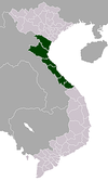 | |
| Nghệ An Province | ||
| Hà Tĩnh Province | ||
| Quảng Bình Province |
| |
| Quảng Trị Province | ||
| Thừa Thiên Huế Province |
| |
※ denotes provincial seat. | ||
This article about a location in Hà Tĩnh Province, Vietnam is a stub. You can help Wikipedia by . |
- Districts of Hà Tĩnh province
- North Central Coast geography stubs